Remove ads from site

lanky
11 January 2020 14:55:33


I don’t want to knock anyone’s duck off, but I just can’t see it happening!   


Originally Posted by: Caz 


Looking at how 2019 compares so far with other Januaries that have exceeded 7C as a mean CET, we are just about on course for getting near the record provided this weather type persists for most or all the rest of the month as modelled. These are the graphs for day by day CET and running averages for the month


But then if you look at other Januaries that were ahead of 2019 by this stage of the month but ended up as a "bust" this tells a different story


I think it will be close but no cigar


Martin
Richmond, Surrey
Caz
  • Caz
  • Advanced Member
11 January 2020 15:34:58


Looking at how 2019 compares so far with other Januaries that have exceeded 7C as a mean CET, we are just about on course for getting near the record provided this weather type persists for most or all the rest of the month as modelled. These are the graphs for day by day CET and running averages for the month


But then if you look at other Januaries that were ahead of 2019 by this stage of the month but ended up as a "bust" this tells a different story


I think it will be close but no cigar


Originally Posted by: lanky 

2020!     At least you’re only one year out. I was ten out this morning.  I started the current conditions thread and had to edit it as I’d put 2010.   


I think it will be no cigar but I’d be happy to be wrong. 


Market Warsop, North Nottinghamshire.
Join the fun and banter of the monthly CET competition.
lanky
11 January 2020 15:45:04


2020!     At least you’re only one year out. I was ten out this morning.  I started the current conditions thread and had to edit it as I’d put 2010.   


I think it will be no cigar but I’d be happy to be wrong. 


Originally Posted by: Caz 


I always do that - sorry 2020


Martin
Richmond, Surrey
Gavin P
11 January 2020 18:05:24


I always do that - sorry 2020


Originally Posted by: lanky 


I'm struggling to get my brain into 2020 mode on my videos.


No doubt by the time I'm used to 2020 it'll be 2021! 


Rural West Northants 120m asl
Short, medium and long range weather forecast videos @ https://www.youtube.com/user/GavsWeatherVids
Stormchaser
11 January 2020 18:27:41

Well, the 12z GFS seems a bit bonkers to me, but for what it's worth, it has my CET estimate at a very balmy 7.6*C as of 14th, still has it up at 7.3*C as of 21st, but then hammers it down to 6.1*C as of 27th


That's still some 1.5*C above the LTA though, which goes to show just how mild it's looking otherwise!


If you have any problems or queries relating to TWO you can Email [email protected]

https://twitter.com/peacockreports 
2023's Homeland Extremes:
T-Max: 30.2°C 9th Sep (...!) | T-Min: -7.1°C 22nd & 23rd Jan | Wettest Day: 25.9mm 2nd Nov | Ice Days: 1 (2nd Dec -1.3°C in freezing fog)
Keep Calm and Forecast On
Bertwhistle
11 January 2020 19:38:12


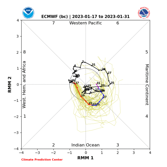
Here's a possible spanner in the works for a record-mild January.


It will depend on how much amplitude the MJO carries into phases 6 and 7, as these promote high pressure across the UK in positions that tend to become chilly at the surface - though only with much probability for phase 7, which is currently looking questionable.


If it only holds through phase 6, then high pressure may dominate but from too far south to bring low temperatures to the CET region.


Incidentally, propagation to phase 7 could also set up some interesting stratospheric events... provided enough of the MJO action is in the N. Hemisphere. I'm still haunted by last year's S. Hemisphere-skewed MJO in Jan-Feb and the resulting huge shortfall on cold UK weather (albeit not entirely fruitless).


Originally Posted by: Stormchaser 


Wow! Fascinating science SC. Keep us updated.


Bertie, Itchen Valley.
Retire while you can still press the 'retire now' button.
ARTzeman
12 January 2020 10:45:38

Met Ofice Hadley       7.3c       Anomaly     3.7c Provisional to 11th.


Metcheck                   7.47c     Anomaly      3.31c


Netweather                7.91c     Anomaly      3.72c


Peasedown St John    8.2c     Anomaly      2.92c


Some people walk in the rain.
Others just get wet.
I Just Blow my horn or trumpet
Argyle77
12 January 2020 11:14:07
be nice to get a january with a minus 3.7c anonmaly,as if....
Spring Sun Winter Dread
12 January 2020 12:10:13
This time 10 years ago the running mean was comfortably below freezing and the talk on here would have been about how far below we would end up and whether it would be coldest since 1979/85/87 etc.
I still think a very cold month can happen but of course the synoptics have to be perfect for it.
Hopefully I'll live in a better insulated house if/ when it does happen again because where I live now I think I would enjoy following it on here alot more than actually living through it !
Stormchaser
12 January 2020 20:21:29

Those seeking cold, snowy winters have been really unlucky in recent years in that there's always been at least one important driving force working against the required patterns establishing.


First it was the solar cycle, then some unhelpful ENSO events (the super Nino; when we benefit from weak to moderate, then a persistent Nina-like tendency even through the weak Nino ocean pattern of last winter) and this time around the big positive Indian Ocean Dipole (IOD) event and the QBO being a bit to slow to transition to the easterly phase from westerly. Looks to get there by mid-late Feb.


The +IOD has weakened a lot in the past fortnight, so who knows, maybe Feb will do something interesting - but only if we see the polar vortex weakened a great deal. No real sign of such in the current NWP modelling range; just the possible brief lower-vortex split... and even that isn't looking as pronounced now (GW should be feeling more comfortable today than yesterday!).


Next winter, we'll be very well placed in the solar cycle and have a fully easterly QBO. The ultimate combination of those two for supporting blocking patterns that bring cold, potentially snowy weather to Northwest Europe (usually with the UK near the edge, as we know all too well!).


So, who's betting that there will be an unhelpful La Nina event  - although that wouldn't necessarily stand in the way of some notably wintry weather Nov-Dec, as a La Nina can promote strong poleward mid-Atlantic ridges before an eastward shift in the favoured ridge location, to Europe, for Jan-Feb.


This last Nov-Dec, there was a Nina-like atmospheric tendency until nearly mid-Dec, but it was too weak to do more than nudge the jet northward in the mid-Atlantic and southward relative to the UK, bringing us cool to chilly conditions, with a lot of unsettled weather, but without temps even falling low enough for snow away from high ground in some northern parts.


If you have any problems or queries relating to TWO you can Email [email protected]

https://twitter.com/peacockreports 
2023's Homeland Extremes:
T-Max: 30.2°C 9th Sep (...!) | T-Min: -7.1°C 22nd & 23rd Jan | Wettest Day: 25.9mm 2nd Nov | Ice Days: 1 (2nd Dec -1.3°C in freezing fog)
Keep Calm and Forecast On
ARTzeman
13 January 2020 10:42:06

Met Office Hadley        7.4c         Anomaly         3.8c Provisional to 12th.


Metcheck                     7.34c       Anomaly          3.19c


Netweather                  7.94c       Anomaly          3.75c


Peasedown St John     8.2c         Anomaly         2.92c.      


Some people walk in the rain.
Others just get wet.
I Just Blow my horn or trumpet
Stormchaser
13 January 2020 11:24:54

Hmm - perhaps I spoke too soon; more emphasis on high pressure building right up across the UK in the model runs so far today.


While not especially cold aloft, overnight frosts and chilly days look possible. Something to keep an eye on - the 06z GFS actually puts slightly more of a dent in the CET than that wild 12z of 11th; rough estimate 5.9*C to 27th as opposed to 6.0*C.


Part of that is due to a colder mid-range; beforehand there was more of a westerly flow being retained across the UK. Still time for that to be the actual outcome, not yet time to rule out an exceptionally high CET.


If you have any problems or queries relating to TWO you can Email [email protected]

https://twitter.com/peacockreports 
2023's Homeland Extremes:
T-Max: 30.2°C 9th Sep (...!) | T-Min: -7.1°C 22nd & 23rd Jan | Wettest Day: 25.9mm 2nd Nov | Ice Days: 1 (2nd Dec -1.3°C in freezing fog)
Keep Calm and Forecast On
Caz
  • Caz
  • Advanced Member
13 January 2020 13:14:43


Hmm - perhaps I spoke too soon; more emphasis on high pressure building right up across the UK in the model runs so far today.


While not especially cold aloft, overnight frosts and chilly days look possible. Something to keep an eye on - the 06z GFS actually puts slightly more of a dent in the CET than that wild 12z of 11th; rough estimate 5.9*C to 27th as opposed to 6.0*C.


Part of that is due to a colder mid-range; beforehand there was more of a westerly flow being retained across the UK. Still time for that to be the actual outcome, not yet time to rule out an exceptionally high CET.


Originally Posted by: Stormchaser 

My logic! It’s bound to turn wintry from 22nd because I’m going on holiday!  It almost always does!  


Market Warsop, North Nottinghamshire.
Join the fun and banter of the monthly CET competition.
Saint Snow
13 January 2020 13:23:18


My logic! It’s bound to turn wintry from 22nd because I’m going on holiday!  It almost always does!  


Originally Posted by: Caz 


Doesn't it normally turn wintry a day or two before you go away, then you're panicky about being able to get to the airport & fly?


Martin
Home: St Helens (26m asl) Work: Manchester (75m asl)
A TWO addict since 14/12/01
"How can wealth persuade poverty to use its political freedom to keep wealth in power? Here lies the whole art of Conservative politics."
Aneurin Bevan
Caz
  • Caz
  • Advanced Member
13 January 2020 14:53:22


Doesn't it normally turn wintry a day or two before you go away, then you're panicky about being able to get to the airport & fly?


Originally Posted by: Saint Snow 

Yes!  You’re right it does turn wintry but it doesn’t usually snow until the day we have to drive to the airport!  I thought I was being clever in 2018 by booking for 1st March but what happened?  Beast from the East!  Then we got it again on our return 16 days later!    


Market Warsop, North Nottinghamshire.
Join the fun and banter of the monthly CET competition.
Whether Idle
13 January 2020 19:15:02


Hmm - perhaps I spoke too soon; more emphasis on high pressure building right up across the UK in the model runs so far today.


While not especially cold aloft, overnight frosts and chilly days look possible. Something to keep an eye on - the 06z GFS actually puts slightly more of a dent in the CET than that wild 12z of 11th; rough estimate 5.9*C to 27th as opposed to 6.0*C.


Part of that is due to a colder mid-range; beforehand there was more of a westerly flow being retained across the UK. Still time for that to be the actual outcome, not yet time to rule out an exceptionally high CET.


Originally Posted by: Stormchaser 


A sub 6c finish is entirely possible depending upon where and how long the high hangs around, plus the last week is obviously in the laps of the Gods.


Dover, 5m asl. Half a mile from the south coast.
ARTzeman
14 January 2020 10:52:58

Met Office Hadley        7.3c       Anomaly      3.8c  Provisional to 13th.


Metcheck                     7.30c     Anomaly       3.15c


Netweather                  7.88c     Anomaly       3.68c


Peasedown St John     8.2c       Anomaly       2.92c


Some people walk in the rain.
Others just get wet.
I Just Blow my horn or trumpet
Stormchaser
14 January 2020 11:50:48


A sub 6c finish is entirely possible depending upon where and how long the high hangs around, plus the last week is obviously in the laps of the Gods.


Originally Posted by: Whether Idle 


The 12z GFS of yesterday dragged my CET estimate all the way down into the low 5s!


However, it was likely among the coldest possible outcomes, with the largest amount of continental flow. Today's runs so far have been far more maritime-dominated, struggling to even produce more than patchy overnight frosts.


So, it appears that anything from low 5s to low 8s is still plausible, with approx. low 6s to mid-7s being the 'probable' range.


If you have any problems or queries relating to TWO you can Email [email protected]

https://twitter.com/peacockreports 
2023's Homeland Extremes:
T-Max: 30.2°C 9th Sep (...!) | T-Min: -7.1°C 22nd & 23rd Jan | Wettest Day: 25.9mm 2nd Nov | Ice Days: 1 (2nd Dec -1.3°C in freezing fog)
Keep Calm and Forecast On
Caz
  • Caz
  • Advanced Member
14 January 2020 14:56:52


The 12z GFS of yesterday dragged my CET estimate all the way down into the low 5s!


However, it was likely among the coldest possible outcomes, with the largest amount of continental flow. Today's runs so far have been far more maritime-dominated, struggling to even produce more than patchy overnight frosts.


So, it appears that anything from low 5s to low 8s is still plausible, with approx. low 6s to mid-7s being the 'probable' range.


Originally Posted by: Stormchaser 

Ha!  I’ll bet you’re just saying that to make me feel better about my 5.2c guess!  


Market Warsop, North Nottinghamshire.
Join the fun and banter of the monthly CET competition.
Hungry Tiger
15 January 2020 10:03:14

My goodness - still over 7.0C


Gavin S. FRmetS.
TWO Moderator.
Contact the TWO team - [email protected]
South Cambridgeshire. 93 metres or 302.25 feet ASL.


ARTzeman
15 January 2020 10:36:38

Met Office Hadley        7.4c.     Anomaly     3.9c. Provisional to 14th.


Metcheck                     7.41c      Anomaly      3.26c


Netweather                  7.95c    Anomaly      3.76c


Peasedown St John     8.3c      Anomaly      3.02c.   


Some people walk in the rain.
Others just get wet.
I Just Blow my horn or trumpet
ARTzeman
16 January 2020 10:44:07

Met Office Hadley        7.4c      Anomaly      3.9c  provisional to 15th.


Metcheck                     7.33c    Anomaly      3.18c


Netweather                  7.91c    Anomaly      3.72c


Peasedown St John      8.2c     Anomaly       2.92c. 


Some people walk in the rain.
Others just get wet.
I Just Blow my horn or trumpet
Stormchaser
16 January 2020 15:14:07


Ha!  I’ll bet you’re just saying that to make me feel better about my 5.2c guess!  


Originally Posted by: Caz 


Rumbled .


No real change in prospects these past two days. Overall model signal is for the high to sit right across the UK until the later next week, then slip away to the southwest, perhaps to a transient cold northwesterly or northerly, after which the pattern looks to flatten out again.


We might finish the month where we began, pattern-wise. Yawn!


If you have any problems or queries relating to TWO you can Email [email protected]

https://twitter.com/peacockreports 
2023's Homeland Extremes:
T-Max: 30.2°C 9th Sep (...!) | T-Min: -7.1°C 22nd & 23rd Jan | Wettest Day: 25.9mm 2nd Nov | Ice Days: 1 (2nd Dec -1.3°C in freezing fog)
Keep Calm and Forecast On
Gusty
17 January 2020 10:36:57

This high pressure could prune a degree off the CET in the next week. By this time next week we could be sitting somewhere close to 6.4c.


The last week is uncertain...deep down I suspect most of us know which way it will go. 


Somewhere between 6.1 and 6.6 is my current end of month estimate...closer to 7 if we drag some long fetch long duration moisture laden SW'lies.


Steve - Folkestone, Kent
Current conditions from my Davis Vantage Vue
https://www.wunderground.com/dashboard/pws/IFOLKE11 
Join Kent Weather on Facebook.
https://www.facebook.com/stevewall69/ 


ARTzeman
17 January 2020 10:46:12

Met Office Hadley       7.5c      Anomaly    3.9c. Provisional to 16th.


Metcheck                    7.42c    Anomaly     3.27c


Netweather                 7.96c    Anomaly     3.77c


Peasedown St John     8.3c     Anomaly     3.02c.  


Some people walk in the rain.
Others just get wet.
I Just Blow my horn or trumpet
Users browsing this topic
    Ads