The winter of 1939-40 was the coldest for 45 years with a CET of 1.5 and contained one of the coldest months on record.
The winter started off mild, a carry over from the very mild November, CET 8.7 (+2.9) but it became cooler during first fortnight of December. First half December: 4.7
The real cold spell came during the latter half of December 1939 when an anticyclone became established and this brought frosts and fog at night.
January 1940 was a severe wintry month with frequent frosts and heavy snowfalls. The CET for the month was -1.4C, the first sub zero CET month of the 20th Century and the coldest month since February 1895.
After an initial cold start to January, it became milder around the 6th as a southerly flow covered the UK
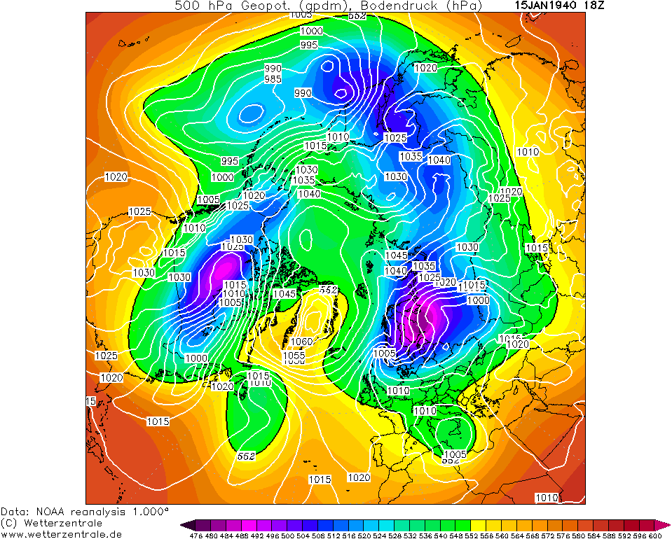
By the 10th, an anticyclone from Europe extended across the UK and it became colder again with extensive frosts. The first snowfalls came on a northerly as a low pressure pushed into Scandinavia and pressure built over Greenland. The 16th was a particularly cold day in a biting ENE wind and the following few days were some of the coldest of the weather.
Amazing chart for mid January

On the night of the 23rd, a minimum of -23.3C was recorded at Rhaydaer(Powys) a record low for that date. Other lows include -20C at Canterbury, Welshpool, Hereford and Newport in Shropshire.
The Thames was frozen for 8 miles between Teddington and Sunbury and ice covered stretches of the Mersey, Humber and Severn.
The sea froze at Bognor Regis and Folkestone and Southampton harbours were iced over. The Grand Union Canal was completely frozen over between Birmingham and London. Central London was below freezing for a week and there was skating on the Serpentine on 6" ice.
However January 1940 will always be remembered for the snowstorm and icestorm that struck the UK.
SNOWSTORM
On the 26th, two occlusions were moving up from the SW engaged the cold air over the UK. At the same time, the anticyclone over Scandinavia was intensifying blocking the fronts from pushing through the UK, they became stationary over Wales and SW England. This resulted in a great snowstorm across many northern and eastern areas.
Vast areas of northern England reported between 30-60cm of level snow, the higher parts in excess of 60cm+. The snow drifted in the strong SEly wind even in the centre of London. Other reports of snow depths include Eastbourne:- 25cm, Pontefract:- 37cm, Malvern:- 60cm and Exmoor:- drifts of 2.5m. The snowfall lasted to the 29th of January
ICESTORM
On the low ground in the south, the preciptation fell as freezing rain. The raindrops were of the supercooled nature, so when the rain hit the surface it would freeze instantly. This is a rare event in the UK and the 1940 is reckoned to be the severest that has struck the UK in recorded history.
The duration of the storm was remarkable lasting up to 48 hours in places. For instance at Cirencester, 48hrs of freezing rain fell in temperatures of between -2 and -4C. The effect of this prolonged icestorm was severe and damaging. Many telegraph poles and wires were snapped unable to cope with the weight of the ice. Flora and fauna suffered as well, many tree branches were snapped off by the enormous weight of ice, birds were unable to fly because ice accumulated on their wings. Travel was next to impossible as roads and pavements became skating rinks. Any sloped surface was impossible to climb.
The battle between the cold continential air and the milder Atlantic air continued until the end of the month.

The start of February continued the battle and it was the 4th when the Atlantic finally won the skirmish on the 4th. This brought a thaw to the the mass of snow and ice that had accumulated.
The thaw was short lived as the colder air pushed back westwards and it became cold yet again on the 10th.

The winter finally broke on the 20th as mild tropical southwesterlies flloded the UK and the rest of the month was milder
Data for Winter 1939-40
December 1939: 3.2 (-1.5)
January 1940: -1.4 (-5.6)
February 1940: 2.6 (-1.4)
January 1940 is the 11th coldest on record, the nights were especially cold with a CET minimum of -4.5C
The coldest spells of the winter
28th Dec-4th Jan: -1.7
10th-19th Feb 1940: -1.8
10th-24th Jan 1940: -3.5
10th January-19th February: -1.2
28th Dec-19th Feb: -0.8
Second half of January: -2.7
First half of February: 0.8
The mildest CET day: 12.5C 27th February
The coldest CET day: -3.8C 20th January
The coldest CET night: -13.4C 21st January
This was the first winter of the Second World War and the cold hit many parts of Europe. Oporto in Portugal and Corunna in Spain reported heavy snowfalls, the first for many years. In Norway and Sweden, the mercury in thermometers froze, the Danube froze and th morale of Allied men awaiting for the Germans was severely affected by the penetrating cold.
Weather reports in newspapers were severely restricted because of the war with any reports being issued a fortnight after the event.
Here are Guardian reports on the January of 1940
The severity of the cold
https://i.imgur.com/KFIr5LQ.jpg
Train/transport chaos because of the snow
https://i.imgur.com/H7MKq2O.jpg https://i.imgur.com/NX4hjUE.jpg https://i.imgur.com/66If2zm.jpg https://i.imgur.com/H3rQ07A.jpg
Bolier explosions and fog
https://i.imgur.com/2yMLca2.jpg
Photos
https://i.imgur.com/YRC4MDZ.jpg https://i.imgur.com/IDcDGan.jpg
Buxton isolated
https://i.imgur.com/8HYWpQP.jpg
Temperatures
https://i.imgur.com/QmMlfCE.jpg
https://i.imgur.com/fhOeOM4.jpg
https://i.imgur.com/q8fqnOg.jpg
Snowstorm
https://i.imgur.com/FFcmZH2.jpg
https://i.imgur.com/xcVFjyq.jpg
Edited at by moderator
17 November 2021 14:49:56
|
Reason: Not specified
MANCHESTER SUMMER INDEX for 2021: 238
Timelapses, old weather forecasts and natural phenomena videos can be seen on this site
http://www.youtube.com/channel/UCgrSD1BwFz2feWDTydhpEhQ/playlists