Remove ads from site

Russwirral
10 January 2024 16:02:21

No sign of the high impact snow event though.

Originally Posted by: Ally Pally Snowman 


My hope is this will be discovered within 48 hrs of the event.  I dont like the idea of seeing an event 7 days out and praying and hoping or it to materialise.

I like the idea of a ticket to a party, and not knowing what to expect, than to pin my hopes on having good time.

Ignorance is bliss.
picturesareme
10 January 2024 16:05:58

No sign of the high impact snow event though.

Originally Posted by: Ally Pally Snowman 


Good because impact snow event would almost certainly mean milder wetter weather here!! 
ballamar
10 January 2024 16:07:55

No sign of the high impact snow event though.

Originally Posted by: Ally Pally Snowman 


get the cold in first always best to remember that!
ballamar
10 January 2024 16:12:08
This GFS op could be at the other end of the spectrum from the 6z
Ally Pally Snowman
10 January 2024 16:14:19

Good because impact snow event would almost certainly mean milder wetter weather here!! 

Originally Posted by: picturesareme 


Well GFS 12z going for a high impact rain event.

Snow event now, i know not good for you. But from imby perspective I'll take my chances with it.

 
Bishop's Stortford 85m ASL.
Whiteout
10 January 2024 16:15:46
In terms of the midweek 'event' 6z and 12z sum up the Met's thoughts, too early to pin down detail but they are the ranges...
Home/Work - Dartmoor
240m/785 ft asl
Retron
10 January 2024 16:15:59
We're back to yesterday's "heavy snow for Midlands, torrential rain and mild conditions in the south" scenario. It's quite an odd choice, really, it's looking like it'll either be cold and dry next Wednesday in the far south, or mild and sopping wet!

The 12z GFS T+168, incidentally, has a 6C gradient in 45 miles.... 4C along the M4, 10C along the south coast!

 
Leysdown, north Kent
nsrobins
10 January 2024 16:16:08

This GFS op could be at the other end of the spectrum from the 6z

Originally Posted by: ballamar 


Indeed - the option of the over enthusiastic Az low is appearing again on this particular operational. It should disrupt East from 162 but it’s going to keep the South out of the snow equation at least for awhile. If it’s correct of course.
Neil
Fareham, Hampshire 28m ASL (near estuary)
Stormchaser, Member TORRO
Saint Snow
10 January 2024 16:17:33

Well GFS 12z going for a high impact rain event
 

Originally Posted by: Ally Pally Snowman 


🤗

Martin
Home: St Helens (26m asl) Work: Manchester (75m asl)
A TWO addict since 14/12/01
"How can wealth persuade poverty to use its political freedom to keep wealth in power? Here lies the whole art of Conservative politics."
Aneurin Bevan
Whiteout
10 January 2024 16:20:36
And so the front stalls and edges back south with cold air digging in behind, Midlands hammered but further south could see a rain to snow event.

Whichever way you look at it, somewhere is going to get a serious pasting, you can see why the Met are concerned..

On this run, I would be very happy if I lived in Stafford lol
Home/Work - Dartmoor
240m/785 ft asl
Ally Pally Snowman
10 January 2024 16:22:01
Massive Midlands snow event back on. Met office seem more confident today so not surprised to see GFS bring it back.

https://www.wetterzentrale.de/en/topkarten.php?map=20&model=gfs&var=25&run=12&time=192&lid=OP&h=0&mv=0&tr=3#mapref 
 
Bishop's Stortford 85m ASL.
Retron
10 January 2024 16:22:14
The 12z GFS snow at 192 is almost the complete opposite (over England) of the 6z 198! Except for Kent, of course, which gets bugger-all in both runs. 😂

6z 198 on left, 12z 192 on right.

https://images.meteociel.fr/im/49/25360/gfs_16_198jyw8.png 
https://images.meteociel.fr/im/21/12514/gfs_16_192oij4.png 
UserPostedImageUserPostedImage
Leysdown, north Kent
Whiteout
10 January 2024 16:23:42
UKMO looks like the other end of the spectrum with the LP, heading south...
Home/Work - Dartmoor
240m/785 ft asl
Ally Pally Snowman
10 January 2024 16:24:55
No mild breakdown after the snow event so could be a win win. Excellent run again
Bishop's Stortford 85m ASL.
Retron
10 January 2024 16:31:09

No mild breakdown after the snow event so could be a win win. Excellent run again

Originally Posted by: Ally Pally Snowman 


Meanwhile 45 miles to your SE, it's a sucky run - one of several over the past few days. The only thing worse than having more torrential rain would be more high winds - at least that's not on the menu for now! It's just us in the far SE and south that miss out, mind you... it's a great run for everyone else.

Here's hoping ICON (or to a lesser extent MetO) have this right. I'd much rather see the cold get all the way south first, before we start to get attacks barrelling in. Having it stall before it gets down here is the worst of both worlds.

Incidentally, have I mentioned how much I love GEM? Well, I do today, anyway! 🤣

https://images.meteociel.fr/im/51/20784/gem_16_222ume8.png
UserPostedImage 

https://images.meteociel.fr/im/89/28958/gem_0_222jly6.png
UserPostedImage 
Leysdown, north Kent
Ally Pally Snowman
10 January 2024 16:33:56
Indeed wonderfully snowy GEM truly stunning 
Bishop's Stortford 85m ASL.
Ally Pally Snowman
10 January 2024 16:36:30
Another massive snow event on the GFS.   Incredible output this afternoon. 

https://www.wetterzentrale.de/en/topkarten.php?map=20&model=gfs&var=53&run=12&time=234&lid=OP&h=0&mv=0&tr=6#mapref 
Bishop's Stortford 85m ASL.
Jiries
10 January 2024 16:38:14

Massive Midlands snow event back on. Met office seem more confident today so not surprised to see GFS bring it back.

https://www.wetterzentrale.de/en/topkarten.php?map=20&model=gfs&var=25&run=12&time=192&lid=OP&h=0&mv=0&tr=3#mapref 
 

Originally Posted by: Ally Pally Snowman 


Whatever happen I am more keen to see tempeatures being in proper subzero for any snowy events and near or at -10C at nights which is absolutely more fun and beautiful Alpine scenery.   No fun when temperatures are floating less cold at 1C to 4C and 0 to 2C at nights like recent cold snowy spells.
White Meadows
10 January 2024 16:41:13
Potentially very soggy south of the M4, yet again. 
 
Whiteout
10 January 2024 16:48:49
Not long before the fax charts come into range....
Home/Work - Dartmoor
240m/785 ft asl
Ally Pally Snowman
10 January 2024 16:48:56
GEM is insane after covering most of the UK in snow it ends like this. 1947 esque.

https://www.wetterzentrale.de/en/topkarten.php?map=1&model=gem&var=1&run=12&time=240&lid=OP&h=0&mv=0&tr=6#mapref 
Bishop's Stortford 85m ASL.
Whiteout
10 January 2024 16:56:33
Wow, Met 168 shows the Low heading straight into France lol, that's cleared that up then lol
 
Home/Work - Dartmoor
240m/785 ft asl
Retron
10 January 2024 16:57:16
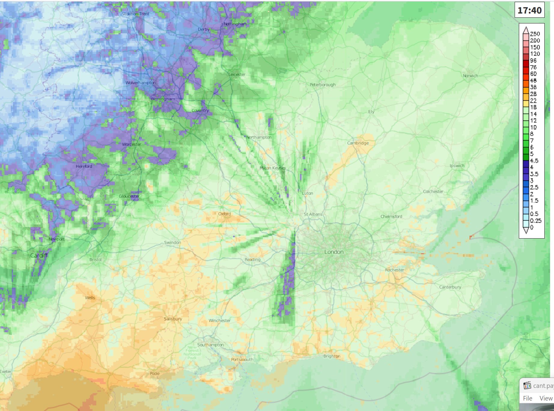
That GFS 12z has to be one of the worst runs I've seen in recent times - aside from high winds, I can't think of much worse than this, really! Just under an inch of rain, and 2 or 3 degrees above freezing. Awful.

You can see, though, where the disruptive potential comes from... as some places would be getting close to a foot of snow from that!

https://ukwct.org.uk/weather/rain.jpg 
UserPostedImage
Leysdown, north Kent
Ally Pally Snowman
10 January 2024 17:02:02

Wow, Met 168 shows the Low heading straight into France lol, that's cleared that up then lol
 

Originally Posted by: Whiteout 


It wouldn't surprise me if it ends up a south of the M4 event . You could be the sweet spot.
 
Bishop's Stortford 85m ASL.
ballamar
10 January 2024 17:17:48

That GFS 12z has to be one of the worst runs I've seen in recent times - aside from high winds, I can't think of much worse than this, really! Just under an inch of rain, and 2 or 3 degrees above freezing. Awful.

You can see, though, where the disruptive potential comes from... as some places would be getting close to a foot of snow from that!

https://ukwct.org.uk/weather/rain.jpg 
UserPostedImage

Originally Posted by: Retron 


Painful to see DP’s that high on an easterly! Plenty of time to change for the better 

Remove ads from site

Ads