Here are two exceptionally low pressures that crossed over UK soil giving record breaking barometer readings
925.6mb at Ochertyre, near Crieff, Perthshire on the 26th January 1884

Here are some barometer readings of this remarkable depression.
London: barometer fell to 28.529" (966mb) at 7.30pm
Dr Beverly of Aberdeen at 11.30pm recorded a barometer reading at sea level of 27.381" (927.1mb)
Forest of Glen Tana, a reading of 27.39" (927.4mb) was recorded
Hitchin: 28.32" (959mb)
North Shields: 27.63" (936mb)
Cargen: 27.66" (936mb)
Oban: 27.39" (927.4mb)
Dublin: 28.15" (953mb)
Croydon: 28.548" (966mb) at 7.40pm
Worksop: 28.292" (958mb)
Some other weather reports
London: Violent SW gale
Stanmore: Terrific gale from SW to W after 4pm
Reigate: Violent storm with very low pressure
Croydon: Strong gale, max hourly velocity of wind 40 miles
Hythe: From 5.30 to 9.30pm, terrific hurricane, with heavy thunderstorm rain and hail
Littlehampton: Awful gale
St Lawrence: Severe SW gale with vivid lightning
Oundle: Hurricane with heavy rain, snow and lightning
Diss: Tremendous gale from west, thunderstorm in evening
Torquay: Fearful SW gale with rain, thunder and lightning
Coventry: Much lightning, violent wind and unusually low bar
Mansfield: Very violent gale with snow, vivid lightning and thunder
Macclesfield: Gales, snow, rain and lightning
Morpeth: A great gale with very low pressure
Penrith: Great storm with extremely low barometer
Elterwater: Great gale with snow, sleet and rain
Llanfrechfa Grange: Violent SW wind, thunder, lightning and rain
Girvan: Severe storm; pressure fell almost 2.5" very rapidly and rose again almost as quickly.
Cassillis: Storm of extraordinary severity with snow and rain
Keith: About two inches of snow fell with fearful drifts on the following day.
Aviemore: Severe gale from west, highland railway blocked by snow
Forsinard: High winds, snow and drifts
Castle Lough: Great storm with heavy rain followed by snow
Kilconnell: Violent storm from SW, veering to NW
Castlebar: Violent storm followed by a fall of snow
Enniskillen: A very severe storm with remarkable fall of pressure; old trees which had stood for 130 years were blown down.
Newtownlands: The most terrific storm since 1839, wind 78 miles an hour.
Douglas: Hurricane from 4pm on 26th to 4am on 27th.
10 days before the great storm, the UK was under high pressure. So some places could have dropped up to 100 millibars in a space of 10 days.
January 1884 was an exceptionally mild month with a CET of 6.5
Remarkably just 3 years after the January 1884 storm, the record came under threat when an exceptional depression tracked across northern parts of the UK on the 8th of December 1886 bringing with it widespread gales and squalls.

Belfast recorded a barometer reading of 927mb
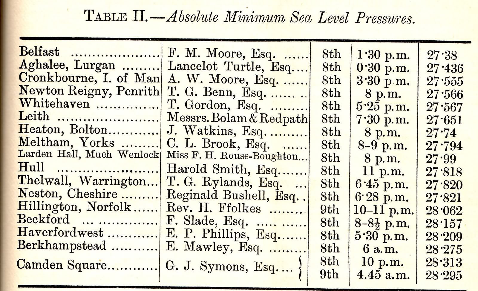
Those values converted into millibars
Belfast: 927.1mb
Lurgan: 928.9mb
Cronkbourne: 933mb
Penrith: 933.4mb
Whitehaven: 933.5mb
Leith: 936.6mb
Bolton: 939.2mb
Meltham: 941.1mb
Hull: 941.9mb
Warrington: 942.0mb
Neston: 942.1mb
Much Wenlock: 947.7mb
Hillington: 950.2mb
Beckford: 953.4mb
Haverfordwest: 955.1mb
Berkhampstead: 957.4mb
Camden Square: 958.7mb (10pm), 958.1mb (4.45am)
Here is a graph of very low pressure readings recorded at Camden Square.
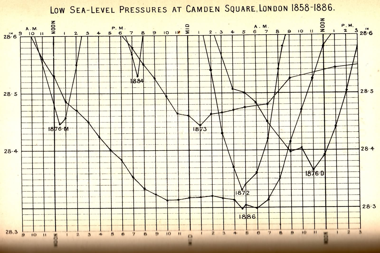
It is interesting to note that Camden Square's barometer was below 959mb for just over 10 hours.
A few reports
Langton Herring: There was a severe storm on the 8th and 9th, when pressure was low for many hours.
Stroud: Severe SW gale with thunder, lightning and hail on 8th
Woolstaston: There was a strong gale on the 8th and 9th with lightning and hail and a remarkable and long continued barometric depression, the lowest reading ever observed occurring about 9pm on the 8th.
Orleton: About 7pm, on the 8th, the bar stood at 27.83 inches (uncorrected) which was nearly a tenth of an inch lower than on the 13th January 1843
Haverfordwest: The damage done to forest trees during the great storm of the 7th and 8th perhaps exceeds anything in living memory.
Killaloe: A great storm occurred on the 8th with very low pressure, the period of greatest violence between 10pm and 1am.
Dublin: Pressure exceptionally low on 8th.
Edenful: On the 8th, we were here in the very centre of a barometric depression, lowere even than that of January 26th 1884. The lowest point was touched at 2pm, when a dead calm prevailed, nor was there any atmospheric disturbance till 1am next morning.
MANCHESTER SUMMER INDEX for 2021: 238
Timelapses, old weather forecasts and natural phenomena videos can be seen on this site
http://www.youtube.com/channel/UCgrSD1BwFz2feWDTydhpEhQ/playlists