Good show Darren, good show 
Back to the NWP output, and I've just watched the ECM unfold.
The +168 to +192 progression had me leaning in a bit and murmuring 'interesting...' but then the following two charts led to a face-palm 
...not because what it does is entirely unreasonable - just rather unlucky if it does manifest; energy phases in the western North Atlantic much like it once looked to do during the next few days, and that results in trough development west of the UK which brings a close to the wild 'cold day, mild day, cold day...' roller-coaster ride.
There's still some positive signs elsewhere though, and with my copy/paste ability restored I can illustrate this:


The key developments are a hefty, vortex-troubling blocking high extending right up to Siberia, and a slight drop in the Arctic Oscillation, perhaps back to negative - though only just. The GFS run was actually a little better as far as the latter goes, while the GFSP was a little worse.
So what might that Siberian block get up to? Well... alongside the benefits in terms of wave-breaking in the stratosphere, there's always the possibility of a stand-off with the UK stuck under a persistent trough.
Then there's the option of low heights sliding underneath and bringing about a cold blast from the east.
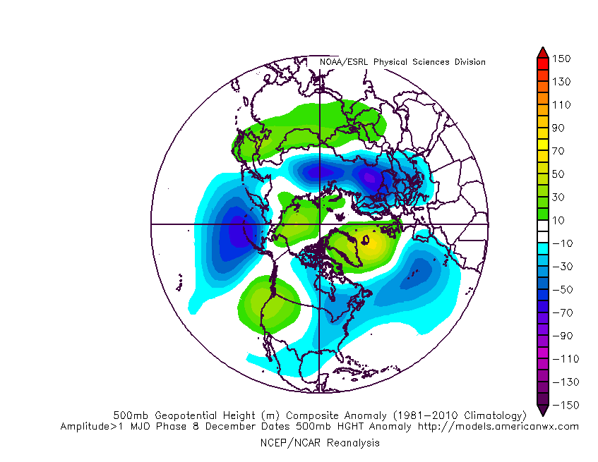
Or in this particular case, if the MJO managed phase 8 before crashing, a more momentous shift in the hemispheric setup could take place, in which the Siberian High transfers poleward and blocking comes to dominate the Arctic with a potentially heavy influence on the UK:

Now if you're wondering where exactly I stand on this possible MJO influence, based on trends over the past few days, some level of influence seems increasingly likely, but the models are consistent in keeping the amplitude fairly low, indicating that the impacts are likely to be fairly weak. My own expectations had been shifting towards us needing to wait for the strat. warming to take effect at the end of this month or early next.
Yet the first of this morning's snippets from the Met Office courtesy of Ian Ferguson gave the impression that GLOSEA 5 and the ECM ensembles were trending toward the establishment of a pattern resembling the phase 8 response within the second half of December, as the signs of a -ve NAO were mentioned.
Then came talk of a continental block featuring in around 40% of the ensembles. The fact that it's positioning was not mentioned suggests to me that it's significance is in what it says about the westerly momentum i.e. that it reduces markedly. From that point it's easier to get the high latitude blocking implied by the -ve NAO.
So perhaps, then, a 40% chance (based on morning runs though - no word on the evening runs) of the pattern becoming favourable for even a weak MJO to encourage height rises to our NW.
Today's NWP output seems a bit half-hearted on that measure... some hints but not really going for it. I'm left sitting on the fence as far as the MJO goes (let alone a notable UK cold spell this side of the New Year), but will keep tracking it so that I can get a feel for how well or poorly the models tend to handle it's behaviour.
If you have any problems or queries relating to TWO you can Email
[email protected] https://twitter.com/peacockreports 2023's Homeland Extremes:
T-Max: 30.2°C 9th Sep (...!) | T-Min: -7.1°C 22nd & 23rd Jan | Wettest Day: 25.9mm 2nd Nov | Ice Days: 1 (2nd Dec -1.3°C in freezing fog)
Keep Calm and Forecast On