Remove ads from site

Zubzero
05 January 2015 20:00:23


A step back for coldies as GEFS at 360h  has virtually no cold members as opposed to 50% at 0h.HP seems to be headed for azores or over  uk which chimes with  with metos more settled option (but not cold) late in January.    


Originally Posted by: roger63 


Maybe, but in the reliable time frame its a zonal outlook, risk of stormy and at time's wintery weather for the north, standard borefest for the south.


After that in guess work land who knows  . Maybe the MJO will phase with a SSW and cause a blizzard with 10 foot drifts in Yate, and 40C with 70% humidity in the isle of Sheppey


idj20
05 January 2015 20:05:10


Here you go Mike:


http://www.emc.ncep.noaa.gov/gmb/STATS/html/new_acz5.html


In the NH the existing GFS is outperforming it. 


Originally Posted by: Brian Gaze 


While we are taking a breather waiting for the next set of output updates, this might sound like a "noob" type question, even though I do think of myself as a bit of a veteran when it comes to amateur meteorology, but what's going to happen to all those apps and web sites that has been relying on GFS data to display "quickie" forecasts being displayed on mobile screens and such like? 


Folkestone Harbour. 
Brian Gaze
05 January 2015 20:08:06


While we are taking a breather waiting for the next set of output updates, this might sound like a "noob" type question, even though I do think of myself as a bit of a veteran when it comes to amateur meteorology, but what's going to happen to all those apps and web sites that has been relying on GFS data to display "quickie" forecasts being displayed on mobile screens and such like? 


Originally Posted by: idj20 


They'll use GFSP!  I'll switch TWO across next week. Could move now but that's a risk given the upstream hardware problems which have led to the GFSP runs being cancelled at times.


Brian Gaze
Berkhamsted
TWO Buzz - get the latest news and views 
"I'm not socialist, I know that. I don't believe in sharing my money." - Gary Numan
idj20
05 January 2015 20:13:04


They'll use GFSP!  I'll switch TWO across next week. Could move now but that's a risk given the upstream hardware problems which have led to the GFSP runs being cancelled at times.


Originally Posted by: Brian Gaze 


Aaah, had mental images of app software designers being up all night burning the midnight oil trying to get everything to work with the new GFSP.

Anyway, sorry for steering this thread off topic.

In a nutshell, looking very lively at times over the northern half of the UK in the next week or so, but it looks like the Azores ridge may help to keep the worst of the stormy stuff at bay at this end. Good, even though some gales are expected.

As for that "pattern change" at around the 17th onwards, it all looks quite cold but dry and settled with frost and fog becoming a regular feature once again. I can live with that.


Folkestone Harbour. 
Stormchaser
05 January 2015 20:41:15

The MJO updates are out... here are the two extremes - GEFS versus ECMF:
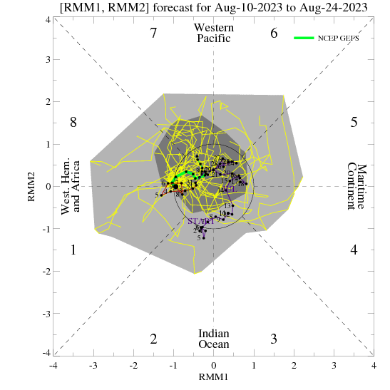
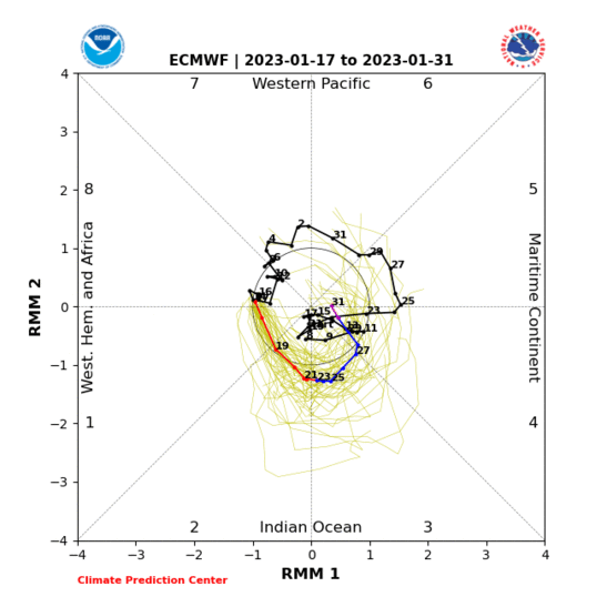


The most striking aspect is just how strong and progressive the GEFS has the MJO becoming. That would be on a scale not seen for a long time!


Then we see that ECMF remains far less enthusiastic with both the strength and progression... but it has increased the progression since the update of two days ago. The MJO actually hits phase 7 with decent amplitude before decaying.


Somewhat ironically, GEFS are now taking the MJO too far before decay for the pattern amplification to evolve in the right way for cold conditions in the second half of January - just look at the phase 8 composite:
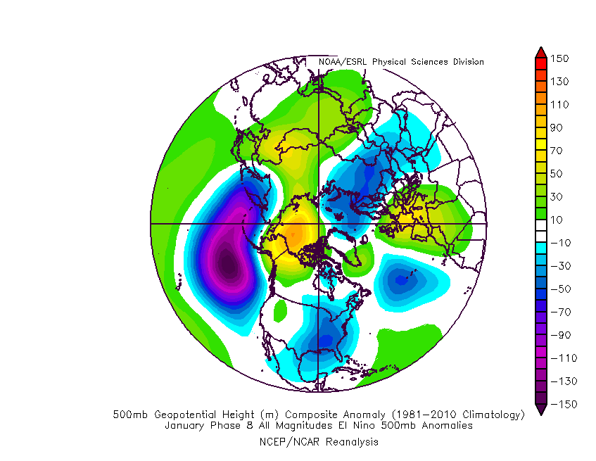


Strong UK/Europe high. Sound familiar? It's pretty much what the GEFS synoptic/500mb output has trended toward today. It's a good pattern for driving wave breaking into the stratosphere but that would probably end up producing results in February.


With this in mind, a halfway house between GEFS and ECMF would be ideal for a January cold spell... and that's what the bias corrected GEFS show (below-left):
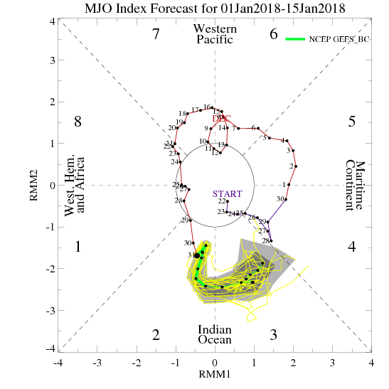
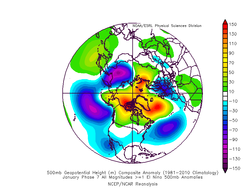


The gradual decay in phase 7 from high amplification is a good way to drive a response in the pattern (toward the phase 7 composite, above right). GEFS was closer to this back on Saturday, and back then the output had a lot more blocking to the NW taking place.


The way I see it, this wide disagreement means that neither the GEFS or ECM ensembles can be taken all that seriously right now - not until one backs down or we see a coming together somewhere in the middle.


No reason to call a cold spell, and no reason to call it off either 


If you have any problems or queries relating to TWO you can Email [email protected]

https://twitter.com/peacockreports 
2023's Homeland Extremes:
T-Max: 30.2°C 9th Sep (...!) | T-Min: -7.1°C 22nd & 23rd Jan | Wettest Day: 25.9mm 2nd Nov | Ice Days: 1 (2nd Dec -1.3°C in freezing fog)
Keep Calm and Forecast On
Chiltern Blizzard
05 January 2015 21:24:39


The MJO updates are out... here are the two extremes - GEFS versus ECMF:


The most striking aspect is just how strong and progressive the GEFS has the MJO becoming. That would be on a scale not seen for a long time!


Then we see that ECMF remains far less enthusiastic with both the strength and progression... but it has increased the progression since the update of two days ago. The MJO actually hits phase 7 with decent amplitude before decaying.


Somewhat ironically, GEFS are now taking the MJO too far before decay for the pattern amplification to evolve in the right way for cold conditions in the second half of January - just look at the phase 8 composite:


Strong UK/Europe high. Sound familiar? It's pretty much what the GEFS synoptic/500mb output has trended toward today. It's a good pattern for driving wave breaking into the stratosphere but that would probably end up producing results in February.


With this in mind, a halfway house between GEFS and ECMF would be ideal for a January cold spell... and that's what the bias corrected GEFS show (below-left):


The gradual decay in phase 7 from high amplification is a good way to drive a response in the pattern (toward the phase 7 composite, above right). GEFS was closer to this back on Saturday, and back then the output had a lot more blocking to the NW taking place.


The way I see it, this wide disagreement means that neither the GEFS or ECM ensembles can be taken all that seriously right now - not until one backs down or we see a coming together somewhere in the middle.


No reason to call a cold spell, and no reason to call it off either 


Originally Posted by: Stormchaser 


Very interesting analysis indeed.... Thank you.


Rendlesham, Suffolk 20m asl
Fothergill
05 January 2015 21:27:42

The NAEFS anomaly charts seem to lend support to the idea of mid-Atlantic/UK high developing, later flattening perhaps. A continuing strong vortex looks likely to prevent any HLB with negative height anomalies continuing around Greenland.


nsrobins
05 January 2015 22:05:03

Several deep lows still forecast to impact N Scotland especially over the next 7 days as they ride and feed off a particularly strong 300mb jet = up to 240mph later this week. Very strong winds will be the headline IMO - for now.


Neil
Fareham, Hampshire 28m ASL (near estuary)
Stormchaser, Member TORRO
Brian Gaze
05 January 2015 22:12:41

GFSP 18z going for 107mph gusts! Off the colour scale hence why it appear gray.


http://www.theweatheroutlook.com/twodata/datmdlout.aspx


Brian Gaze
Berkhamsted
TWO Buzz - get the latest news and views 
"I'm not socialist, I know that. I don't believe in sharing my money." - Gary Numan
Medlock Vale Weather
05 January 2015 22:24:27


GFSP 18z going for 107mph gusts! Off the colour scale hence why it appear gray.


http://www.theweatheroutlook.com/twodata/datmdlout.aspx


Originally Posted by: Brian Gaze 


Not a day to wear a kilt on the Isle of Lewis!  if it carries on later in the day.


Alan in Medlock Valley - Oldham's frost hollow. 103 metres above sea level.
What is a frost hollow? http://www.weatheronline.co.uk/reports/wxfacts/Frost-hollow.htm 
nsrobins
05 January 2015 22:43:24

I see GFSP wants to deliver another of it's apocalypse lows to the UK next week. Have a look at +222 LOL - 948mb and still deepening.


Neil
Fareham, Hampshire 28m ASL (near estuary)
Stormchaser, Member TORRO
Gooner
05 January 2015 22:44:55

http://modeles.meteociel.fr/modeles/gfsp/runs/2015010518/gfsnh-0-228.png?18


Where is the UK


Remember anything after T120 is really Just For Fun


Marcus
Banbury
North Oxfordshire
378 feet A S L


Matty H
  • Matty H
  • Advanced Member Topic Starter
05 January 2015 22:45:56

Does anyone know why the GFS has a tendency for seemingly hugely over-egging these dartboard lows on a regular basis, only to temper them as time shortens? Or is it just one of those things that seems to happen, but doesn't really? Like SSW being the be all and end all of winter, etc?


Russwirral
05 January 2015 23:08:43


Does anyone know why the GFS has a tendency for seemingly hugely over-egging these dartboard lows on a regular basis, only to temper them as time shortens? Or is it just one of those things that seems to happen, but doesn't really? Like SSW being the be all and end all of winter, etc?


Originally Posted by: Matty H 


It did that alot back in Early December.  With every other run going for a dart board low, then slowly ebbing it back to a lack LP.


Solar Cycles
06 January 2015 00:12:50
The GFS going into its usual ramp mode with next weeks potential storms, it's like the boy that cried wolf.
The Beast from the East
06 January 2015 00:13:10


I see GFSP wants to deliver another of it's apocalypse lows to the UK next week. Have a look at +222 LOL - 948mb and still deepening.


Originally Posted by: nsrobins 


What is apparent is the lack of HLB development in the ensembles now. This cold spell is over before its begun. At least we had a few frosts this winter but it is turning out to be yet another year to pass us by. The  return of the "modern winter". 09/10 and Dec 10 were just a blip


"We have some alternative facts for you"
Kelly-Ann Conway - special adviser to the President
David M Porter
06 January 2015 00:40:55


What is apparent is the lack of HLB development in the ensembles now. This cold spell is over before its begun. At least we had a few frosts this winter but it is turning out to be yet another year to pass us by. The  return of the "modern winter". 09/10 and Dec 10 were just a blip


Originally Posted by: The Beast from the East 


No disrespect Beast, but I think that posts like this are better suited to the winter moaning/lack of snow thread. Saying that the cold spell is over before it's begun is daft IMO, when it looks as if it will be mid-January or just after that before we even reach the point where the pattern may change somewhat from the current one. The colder, more settled spell being suggested by the GFS may be downgraded as the time gets nearer, but there again it may not be. It's only January 6th for heaven's sake, not the end of February.


Lenzie, Glasgow

"Let us not take ourselves too seriously. None of us has a monopoly on wisdom, and we must always be ready to listen and respect other points of view."- Queen Elizabeth II 1926-2022
Quantum
06 January 2015 01:08:38

Reckon ECM0z 240hr first eye candy chart from this model in a while.


2023/2024 Snow days (approx 850hpa temp):
29/11 (-6), 30/11 (-6), 02/12 (-5), 03/12 (-5), 04/12 (-3), 16/01 (-3), 18/01 (-8), 08/02 (-5)

Total: 8 days with snow/sleet falling.

2022/2023 Snow days (approx 850hpa temp):

18/12 (-1), 06/03 (-6), 08/03 (-8), 09/03 (-6), 10/03 (-8), 11/03 (-5), 14/03 (-6)

Total: 7 days with snow/sleet falling.

2021/2022 Snow days (approx 850hpa temp):

26/11 (-5), 27/11 (-7), 28/11 (-6), 02/12 (-6), 06/01 (-5), 07/01 (-6), 06/02 (-5), 19/02 (-5), 24/02 (-7), 30/03 (-7), 31/03 (-8), 01/04 (-8)
Total: 12 days with snow/sleet falling.
Retron
06 January 2015 03:54:25


No disrespect Beast, but I think that posts like this are better suited to the winter moaning/lack of snow thread.


Originally Posted by: David M Porter 


Definitely - it's amazing how some will write off a colder spell even though it's still shown in the ensembles!


I've said for several days now that the ensembles indicate a colder spell - not bone-crushingly cold and snowy by any means, but at least on the cold side of average. I've seen nothing to change my mind on that either, with GEFS having the majority of runs in the cold cluster and ECM still having roughly half its runs in the cold cluster.


It's worth mentioning that I don't pay too much attention to SSW (if we get some during a given winter, good, but it's not the be all and end all) and similarly with the MJO (it's a factor, but a small one IMO).


Leysdown, north Kent
Snowedin3
06 January 2015 06:23:16

A bit O/T but was the Model output discussion thread during  and the lead up to December 2010 archived? would like to have a  nose through memory lane  


Dean Barnes
Finstock, Chipping Norton, Oxfordshire
160m ASL 525 Ft
Brian Gaze
06 January 2015 06:53:27


Definitely - it's amazing how some will write off a colder spell even though it's still shown in the ensembles!


I've said for several days now that the ensembles indicate a colder spell - not bone-crushingly cold and snowy by any means, but at least on the cold side of average. I've seen nothing to change my mind on that either, with GEFS having the majority of runs in the cold cluster and ECM still having roughly half its runs in the cold cluster.


It's worth mentioning that I don't pay too much attention to SSW (if we get some during a given winter, good, but it's not the be all and end all) and similarly with the MJO (it's a factor, but a small one IMO).


Originally Posted by: Retron 


I agree with you but think it's down to expectations. The post Xmas spell was cold but for me it passed almost unnoticed and if I wasn't running this site I'd have thought nothing of it, other than 'it's nippy this morning but it's winter'. What I'm looking for in a cold spell is a period where the ENS drop down close to -10C 850hPa (I know these values aren't the be all and end all by any means) and stay there a good while and I've not seen that at any point this winter so far.


The overnight GEFS 2m temps support what you're saying but to me look very underwhelming. 


http://www.theweatheroutlook.com/twodata/datmdlout.aspx


Brian Gaze
Berkhamsted
TWO Buzz - get the latest news and views 
"I'm not socialist, I know that. I don't believe in sharing my money." - Gary Numan
Nordic Snowman
06 January 2015 07:03:45
What is interesting for me is the GFS vs GFSP. We have always thought that the GFS can overcook the Lows but also has a tendency to bring them further S. The reality, in most cases, will see the Lows push a tad further N and E than modelled. This is what I am seeing with the GFSP now. The Low at the end of the week, for example, has been consistently modelled just a little further N than shown on GFS. Has that bias been corrected/tackled?

Hard to tell from that alone but as Brian posted last night, the verification stats actually show GFS performing better than GFSP in the last week or so.

Will N Scotland get the strongest winds or will S Norway? :-D

We'll soon find out....
Bjorli, Norway

Website 
Retron
06 January 2015 07:21:41


 What I'm looking for in a cold spell is a period where the ENS drop down close to -10C 850hPa (I know these values aren't the be all and end all by any means) and stay there a good while and I've not seen that at any point this winter so far.


Originally Posted by: Brian Gaze 


FWIW, I use -10C at 850 as an indicator of a decent cold spell, ie one in which ice days are possible (even towards the end of February down here) and one in which snow is likely. It's very unusual to get -10C for more than a day or two, but if there are plenty of ensemble members showing spiking that low then it's a good indicator of a deep cold spell.


I remember well the approach to 2010 - the ensembles showed the odd -10C, then rather more -10Cs, but generally only ever for a day or two at most per member. They also showed, as you mention, a prolonged cluster of -7s and -8s down here, which is realistically about as good as it ever gets in the ensembles.


This time there's been the odd spike down to -10C (all the four GEFS suites yesterday, for example) but there's not the signature yet of a prolonged period of -7s and -8s - hence although I feel a cold spell is still likely, it's not going to be earth-shatteringly cold. On the other hand, when you get shortlived -7s and -8s wrapped around low pressure (as happened after Christmas) it does raise the stakes of a real dumping of snow somewhere. Sod's law says it's unlikely to be anywhere near where you actually live (Sheffield copped it last time), which is why I'd much prefer a deep cold, unstable easterly. However, beggars can't be choosers and at least there's a risk of snow somewhere in the current outlook, as opposed to no risk whatsoever (unless you're on top of a mountain!)


Leysdown, north Kent
Nordic Snowman
06 January 2015 07:32:15

ECM's OP is a little all over the place recently IMO, in the post T192 range.


ECM 00z T+240:


Postage Stamps for GFS 18z last night at T+240:


Hard to see but generally most are showing the trough to the NE of the UK and also affecting the UK.


If ECM is picking a new trend, well...... you can write off the 2nd half of January too (IMO)


Bjorli, Norway

Website 
nsrobins
06 January 2015 07:43:28

The waning of the potential for a cold spell (definition as per Brian's post earlier) continues, and I will not be criticised for stating the obvious!
I too quite liked the signals late last week with a consistent cluster of ENS in the -7/-8 range but as the days have gone by this has been eroded and the 00Z GFS set is almost back to clutter and the sinusoidal pattern we've seen for some time now. The gradient and ensuing jet out of the E Seaboard is generating lows that scupper attempts at HLB and the mean height anomaly has continued to show a trough to our N and NE and high to our SW - not a pattern conducive for decent cold weather in the UK.
It would be unlikely on the current and trending signals to see anything in the way of a 'decent' cold spell now before the end of January.


To appease the fundamentalists in this thread, I am saying nothing about February. It is outside the range of any forecaster. I am also saying nothing about SWW, etc. That would be totally off topic.


Neil
Fareham, Hampshire 28m ASL (near estuary)
Stormchaser, Member TORRO

Remove ads from site

Ads