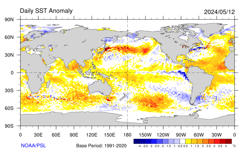
The airmass we have today circulated around the high having tracked across the northern half of the N. Atlantic. This means it traversed an unusually large area of colder than average waters, which has been developing over the past few months:

So you'd expect it to bring unusually low temperatures whenever we import an airmass from the west or northwest, which unfortunately tends to be quite often for the UK. We're in line for another shot this weekend, slowly pushing south, affecting all areas by Monday, slowly mixing out during Tuesday provided that ridge does push east as currently projected by the vast majority of model output.
If we happen to see air from the southwest in the near future (our supposed predominant wind direction...), that looks capable of bringing near normal temperatures, depending on cloud amounts and rain of course.
There still remains an excess of heat in the Mediterranean that could give any Spanish Plumes a boost, as I said when undertaking similar analysis last month - but the evidence of recent times points towards this anomalous heat leading to a lot of in-situ instability that tends to interfere with the transport of the hot air northward, so it may take a well organised low to the west of Portugal to achieve much this summer.
We'll be seeing a rather lazy looking plume extend across southern parts on Thursday and affecting much of England and Wales on Friday. The initial push could bring a few imported storms for the far south Thursday evening, though they look to be classic 'Channel Crossers' in the sense that they struggle to hold together, leaving us looking for anything that develops along the South Coast as the southerly drift meets the land and drives some extra uplift.
Provided the residual cloud from such storms breaks down enough by the following morning, Friday could see a more unstable environment over the UK, with strong homegrown activity. With light winds, some locally very high rain totals are possible (or hail...). What I'm really keeping an eye on is possible seeds for organisation (areas of spin... vort. maxes) being offered by the shallow low drifting across England and Wales. That could lead to a serious deluge for some parts, depending on the available moisture - which at this stage looks pretty high.
If you have any problems or queries relating to TWO you can Email
[email protected] https://twitter.com/peacockreports 2023's Homeland Extremes:
T-Max: 30.2°C 9th Sep (...!) | T-Min: -7.1°C 22nd & 23rd Jan | Wettest Day: 25.9mm 2nd Nov | Ice Days: 1 (2nd Dec -1.3°C in freezing fog)
Keep Calm and Forecast On