Remove ads from site

four
  • four
  • Advanced Member
24 July 2015 16:13:57

Currently 14.5C 😱

That's shocking for this time of year! The average overnight low is warmer than this normally.

Originally Posted by: picturesareme 


Would be a fairly normal warmish summer day for here 


Charmhills
24 July 2015 16:24:16

Just 13c here and breezy.


Loughborough, EM.

Knowledge is power, ignorance is weakness.

Duane.
Essan
24 July 2015 16:56:17

Well, I am currently looking at my coldest July day on record.

Max so far is 14.6c at 00.44am

Previous record holder - 14.8c - was 21st July 2007, the "Day of the Flood".   Not quite as wet as it was back then, although been raining all day.


Andy
Evesham, Worcs, Albion - 35m asl
Weather & Earth Science News 

Anyone who is capable of getting themselves made President should on no account be allowed to do the job - DNA
Retron
24 July 2015 16:58:38

A high of just 18.2C here today - the first time it's not reached 20C since the 23rd June, and at long last a below-average day temperature wise!


Leysdown, north Kent
Chunky Pea
24 July 2015 17:43:41


A high of just 18.2C here today - the first time it's not reached 20C since the 23rd June, and at long last a below-average day temperature wise!


Originally Posted by: Retron 


You should move to Ireland Retron. Nothing but below average temps all Summer.


Current Conditions
https://t.ly/MEYqg 


"You don't have to know anything to have an opinion"
--Roger P, 12/Oct/2022
Quantum
  • Quantum
  • Advanced Member Topic Starter
24 July 2015 18:02:45


A high of just 18.2C here today - the first time it's not reached 20C since the 23rd June, and at long last a below-average day temperature wise!


Originally Posted by: Retron 


18.2C, is only a couple of degrees off the All time Aberdeen warm record 


2023/2024 Snow days (approx 850hpa temp):
29/11 (-6), 30/11 (-6), 02/12 (-5), 03/12 (-5), 04/12 (-3), 16/01 (-3), 18/01 (-8), 08/02 (-5)

Total: 8 days with snow/sleet falling.

2022/2023 Snow days (approx 850hpa temp):

18/12 (-1), 06/03 (-6), 08/03 (-8), 09/03 (-6), 10/03 (-8), 11/03 (-5), 14/03 (-6)

Total: 7 days with snow/sleet falling.

2021/2022 Snow days (approx 850hpa temp):

26/11 (-5), 27/11 (-7), 28/11 (-6), 02/12 (-6), 06/01 (-5), 07/01 (-6), 06/02 (-5), 19/02 (-5), 24/02 (-7), 30/03 (-7), 31/03 (-8), 01/04 (-8)
Total: 12 days with snow/sleet falling.
LeedsLad123
24 July 2015 18:05:14


It can be a little deceptive though. I think the coldest day of the year statistically is in February; but January is still the coldest month. In regards to the warmest week that would be a very close battle between the last week of July and the first week of August. Perhaps the first week of August would have a slight edge. However Week 2,3 and 4 of August would loose out to week 3, 2 and 1 of July. 


Originally Posted by: Quantum 


I worked out the averages for the final week of July and first week of August for Leeds using Tutiempo (old Weather Centre which no longer exists).


Average high/low for final week of July: 22.0/13.4


Average high/low for first week of August: 22.0/13.2C


July is warmer on the whole though, of course.


The fact that I had to work the averages out manually though is pathetic - why doesn't the Met Office have tools like NOAA in the US where you can calculate the averages in a few seconds? For a public service we fund, we sure as hell don't get a lot of data to look at!


Whitkirk, Leeds - 85m ASL.
richardabdn
24 July 2015 20:12:55


18.2C, is only a couple of degrees off the All time Aberdeen warm record 


Originally Posted by: Quantum 


For the 2nd half of October which coincidentally is what summer always feels like these days 


Aberdeen: The only place that misses out on everything


2023 - The Year that's Constantly Worse than a Bad November
2024 - 2023 without the Good Bits
picturesareme
24 July 2015 20:17:32


Would be a fairly normal warmish summer day for here 


Originally Posted by: four 


lol 😄 I guess you'd make up for I with winter snows.

springsunshine
24 July 2015 21:31:31

This is the coldest July day I can ever recall,day time temps have been fluctuating between 13c-14c with non stop rain since 5am.Ive even had to put the heating on for a couple of hours this evening to take the damp chill away!


Unbelievable day,only in the uk can you get the same temperature in July as is possible in January

24 July 2015 21:50:23


Well, I am currently looking at my coldest July day on record.

Max so far is 14.6c at 00.44am

Previous record holder - 14.8c - was 21st July 2007, the "Day of the Flood".   Not quite as wet as it was back then, although been raining all day.


Originally Posted by: Essan 


Same here. Maximum was 14.7C at one minute past midnight.


will be interesting to see what the 9z to 9z maximum is. So far the highest figure since 9z is 14.0C at 0901

RobR
  • RobR
  • Advanced Member
24 July 2015 22:52:27


Unbelievable day,only in the uk can you get the same temperature in July as is possible in January


Originally Posted by: springsunshine 


Interesting when you point that out as it'd be impossible to get Summer temps in Winter. Quite a depressing statistic really. I noticed the chill when walking the dog this morning. I though we'd avoid the rain in North Midlands but it did rain most of the afternoon.


Winter 23/24 in Nantwich
Days Snow Falling: 4
Days Snow Lying: 1
Deepest Snowfall: 3rd December 23 (2cm)


Winter 22/23 in Nantwich

Days Snow Falling: 4
Days Snow Lying: 2
Deepest Snowfall: 10th March (3cm)
Latest Snowfall: 10th March

Winter 21/22 in Nantwich

Days Snow Falling: 3
Days Snow Lying: 1
Deepest Snowfall: 28th November (3cm)
Latest Snowfall: 31st March

Winter 20/21 in Solihull

Days Snow Falling: 21
Days Snow Lying: 8
Deepest Snowfall: 24th January (9cm)
Latest Snowfall: 12th April

Winter 19/20 in Stoke

Days Snow Falling: 5
Days Snow Lying: 2
Deepest Snowfall: 10th Feb (5cm)

Winter 18/19 in Stoke

Days Snow Falling: 6
Days Snow Lying: 6
Deepest Snowfall: 29th Jan (3cm)

Winter 17/18 in Stoke

Days Snow Falling: 27
Days Snow Lying: 24
Deepest Snowfall: 18th March 2018 (10cm)
ARTzeman
24 July 2015 22:58:37

10.3c. At the moment.


Some people walk in the rain.
Others just get wet.
I Just Blow my horn or trumpet
Stormchaser
24 July 2015 23:08:22

The maximum temperature has been the bigger story of the day here, as it stands at a mere 14.1*C. This beats my previous lowest July maximum record, set on 2nd July 2013 (which went on to be my second hottest July!), by a whopping 0.7*C.


The unusually cold Atlantic is finally making itself felt all the way down here, within around 18 miles of the South Coast.


Weirdly, there five days tied for 3rd place, all maxing out at 15.0*C. I've checked and it's not a rounding error! The dates are 25th and 27th July 2005, 20th July 2007 and 2nd and 7th July 2012.


It's also a curious coincidence that two of my lowest temperatures are both on the 2nd of the month.


I expect that any days of persistent heavy rain in August with the UK stuck on the cold side of the frontal boundary will have a good shot at record low maximums as well.


The current -ve SST anomalies in the N. Atlantic are very impressive, and their alignment produces pretty much the maximum cooling effect on our predominant westerlies:
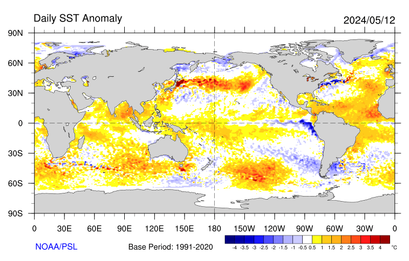


Of course, that alignment is in part a consequence of the westerlies in the first place.


Interesting to note that if we get any long-fetch southwesterly winds in the near future, they are likely to be exceptionally warm.


That band of large positive anomalies extending west from Europe is as striking as the cold anomalies to the north of it. Some suggest that this represents the Atlantic Multi-decadal Oscillation (AMO) turning to a negative phase. I'm not sure one way or another, but on the face of it, it appears that the usual transport of heat poleward (as the atmosphere eternally seeks a balance that can never be fully obtained) is being severely interfered with. Has the Gulf Stream taken a detour well south of normal and/or been weakened by the masses of freshwater exiting Greenland (freshwater interferes with the process... a lesson for another day)? Or is it something else.


Suggestions (or solid answers!) will be much appreciated, thanks - please don't hesitate to voice your take on matters 


Whatever the cause, I'd be surprised to see the -ve anomalies weakened much until late in the year. Seems like the ski resorts could well see an early start to the season. Yes, I'm feeling bold tonight!


If you have any problems or queries relating to TWO you can Email [email protected]

https://twitter.com/peacockreports 
2023's Homeland Extremes:
T-Max: 30.2°C 9th Sep (...!) | T-Min: -7.1°C 22nd & 23rd Jan | Wettest Day: 25.9mm 2nd Nov | Ice Days: 1 (2nd Dec -1.3°C in freezing fog)
Keep Calm and Forecast On
RobR
  • RobR
  • Advanced Member
24 July 2015 23:29:00

It feels like an eternity since 36C was reached....quite how we managed that in the same month where we've struggled to get to 14C is quite crazy.


Winter 23/24 in Nantwich
Days Snow Falling: 4
Days Snow Lying: 1
Deepest Snowfall: 3rd December 23 (2cm)


Winter 22/23 in Nantwich

Days Snow Falling: 4
Days Snow Lying: 2
Deepest Snowfall: 10th March (3cm)
Latest Snowfall: 10th March

Winter 21/22 in Nantwich

Days Snow Falling: 3
Days Snow Lying: 1
Deepest Snowfall: 28th November (3cm)
Latest Snowfall: 31st March

Winter 20/21 in Solihull

Days Snow Falling: 21
Days Snow Lying: 8
Deepest Snowfall: 24th January (9cm)
Latest Snowfall: 12th April

Winter 19/20 in Stoke

Days Snow Falling: 5
Days Snow Lying: 2
Deepest Snowfall: 10th Feb (5cm)

Winter 18/19 in Stoke

Days Snow Falling: 6
Days Snow Lying: 6
Deepest Snowfall: 29th Jan (3cm)

Winter 17/18 in Stoke

Days Snow Falling: 27
Days Snow Lying: 24
Deepest Snowfall: 18th March 2018 (10cm)
picturesareme
25 July 2015 01:51:14


The maximum temperature has been the bigger story of the day here, as it stands at a mere 14.1*C. This beats my previous lowest July maximum record, set on 2nd July 2013 (which went on to be my second hottest July!), by a whopping 0.7*C.


The unusually cold Atlantic is finally making itself felt all the way down here, within around 18 miles of the South Coast.


Weirdly, there five days tied for 3rd place, all maxing out at 15.0*C. I've checked and it's not a rounding error! The dates are 25th and 27th July 2005, 20th July 2007 and 2nd and 7th July 2012.


It's also a curious coincidence that two of my lowest temperatures are both on the 2nd of the month.


I expect that any days of persistent heavy rain in August with the UK stuck on the cold side of the frontal boundary will have a good shot at record low maximums as well.


The current -ve SST anomalies in the N. Atlantic are very impressive, and their alignment produces pretty much the maximum cooling effect on our predominant westerlies:


Of course, that alignment is in part a consequence of the westerlies in the first place.


Interesting to note that if we get any long-fetch southwesterly winds in the near future, they are likely to be exceptionally warm.


That band of large positive anomalies extending west from Europe is as striking as the cold anomalies to the north of it. Some suggest that this represents the Atlantic Multi-decadal Oscillation (AMO) turning to a negative phase. I'm not sure one way or another, but on the face of it, it appears that the usual transport of heat poleward (as the atmosphere eternally seeks a balance that can never be fully obtained) is being severely interfered with. Has the Gulf Stream taken a detour well south of normal and/or been weakened by the masses of freshwater exiting Greenland (freshwater interferes with the process... a lesson for another day)? Or is it something else.


Suggestions (or solid answers!) will be much appreciated, thanks - please don't hesitate to voice your take on matters 


Whatever the cause, I'd be surprised to see the -ve anomalies weakened much until late in the year. Seems like the ski resorts could well see an early start to the season. Yes, I'm feeling bold tonight!


Originally Posted by: Stormchaser 


i still believe event in iceland over the autumn & winter have played a part in all of this. I'm sure some lab techs somewhere are analysing & crunching data as I type. 

bledur
25 July 2015 04:43:22


The maximum temperature has been the bigger story of the day here, as it stands at a mere 14.1*C. This beats my previous lowest July maximum record, set on 2nd July 2013 (which went on to be my second hottest July!), by a whopping 0.7*C.


The unusually cold Atlantic is finally making itself felt all the way down here, within around 18 miles of the South Coast.


Weirdly, there five days tied for 3rd place, all maxing out at 15.0*C. I've checked and it's not a rounding error! The dates are 25th and 27th July 2005, 20th July 2007 and 2nd and 7th July 2012.


It's also a curious coincidence that two of my lowest temperatures are both on the 2nd of the month.


I expect that any days of persistent heavy rain in August with the UK stuck on the cold side of the frontal boundary will have a good shot at record low maximums as well.


The current -ve SST anomalies in the N. Atlantic are very impressive, and their alignment produces pretty much the maximum cooling effect on our predominant westerlies:


Of course, that alignment is in part a consequence of the westerlies in the first place.


Interesting to note that if we get any long-fetch southwesterly winds in the near future, they are likely to be exceptionally warm.


That band of large positive anomalies extending west from Europe is as striking as the cold anomalies to the north of it. Some suggest that this represents the Atlantic Multi-decadal Oscillation (AMO) turning to a negative phase. I'm not sure one way or another, but on the face of it, it appears that the usual transport of heat poleward (as the atmosphere eternally seeks a balance that can never be fully obtained) is being severely interfered with. Has the Gulf Stream taken a detour well south of normal and/or been weakened by the masses of freshwater exiting Greenland (freshwater interferes with the process... a lesson for another day)? Or is it something else.


Suggestions (or solid answers!) will be much appreciated, thanks - please don't hesitate to voice your take on matters 


Whatever the cause, I'd be surprised to see the -ve anomalies weakened much until late in the year. Seems like the ski resorts could well see an early start to the season. Yes, I'm feeling bold tonight!


Originally Posted by: Stormchaser 

I dont really know, but i know i have seen cool summers before and cool wet July days which is typical of a low coming out of Biscay area and tracking through Northern France.  The Atlantic is cold this year, although warmer than average last year . The jetstream is further south most of the time so is bringing air cooled by the Atlantic  more than usual . It was very cold over N.America last winter and that cold pool of air seems to have cooled the ocean along with the extra Greenland meltwater


 Saltwater is denser than freshwater so would be under the very cold meltwater giving a colder than normal surface temp . I would have thought storms and currents would mix the water but maybe that is not the case Also there are the possible effects of El Nino to add in so could be a very interesting period meteorologically. Computer models and forecasters are certainly struggling a bit.

Gavin P
25 July 2015 20:23:56

Q was right to give a "head's up" on this one. Bablake weather station in Cov had their coldest July day since 1978 yesterday! 


http://bablakeweather.co.uk/


Amazing to think that earlier in the month we was baking in record breaking heat, and now some places have had their coldest July day for over 35 years!


Crazy weather.


Rural West Northants 120m asl
Short, medium and long range weather forecast videos @ https://www.youtube.com/user/GavsWeatherVids
Essan
25 July 2015 20:36:49


Q was right to give a "head's up" on this one.


Originally Posted by: Gavin P 


Only if his brother is standing as new labour leader


As Quantum said "I should resurrect this thread. Northerly winds are going to be unusually frequent until the months end at least, and with the Atlantic arctic unusually cold some more 0C 850hpa incursions look probabley"

Nothing to do with the low pressure system from the south bringing heavy rain that coincidently gave us such a cold day in the south


Andy
Evesham, Worcs, Albion - 35m asl
Weather & Earth Science News 

Anyone who is capable of getting themselves made President should on no account be allowed to do the job - DNA
Quantum
  • Quantum
  • Advanced Member Topic Starter
25 July 2015 21:10:31


Feel I should resurrect this thread. Northerly winds are going to be unusually frequent until the months end at least, and with the Atlantic arctic unusually cold some more 0C 850hpa incursions look probable. When combined with rainfall (which is likely given the LP domination) we have a lot more chances to attempt to break the records (either lowest july maximun or lowest july minimun). 


Originally Posted by: Quantum 


You could have included the 2nd part Essan. 


2023/2024 Snow days (approx 850hpa temp):
29/11 (-6), 30/11 (-6), 02/12 (-5), 03/12 (-5), 04/12 (-3), 16/01 (-3), 18/01 (-8), 08/02 (-5)

Total: 8 days with snow/sleet falling.

2022/2023 Snow days (approx 850hpa temp):

18/12 (-1), 06/03 (-6), 08/03 (-8), 09/03 (-6), 10/03 (-8), 11/03 (-5), 14/03 (-6)

Total: 7 days with snow/sleet falling.

2021/2022 Snow days (approx 850hpa temp):

26/11 (-5), 27/11 (-7), 28/11 (-6), 02/12 (-6), 06/01 (-5), 07/01 (-6), 06/02 (-5), 19/02 (-5), 24/02 (-7), 30/03 (-7), 31/03 (-8), 01/04 (-8)
Total: 12 days with snow/sleet falling.
Gavin P
25 July 2015 21:19:10

I think Essan's been a bit mean there.


Rural West Northants 120m asl
Short, medium and long range weather forecast videos @ https://www.youtube.com/user/GavsWeatherVids
four
  • four
  • Advanced Member
26 July 2015 05:55:44

3.8C at 05:30 here, this is unusually low for what should be the warmest time of the year.
There has probably been ground frost is frost hollows.


Hungry Tiger
26 July 2015 11:10:44

Just reading some of the posts on here - There will be some implications for winter this year with the colder than normal Atlantic water in such close proximity.


Gavin S. FRmetS.
TWO Moderator.
Contact the TWO team - [email protected]
South Cambridgeshire. 93 metres or 302.25 feet ASL.


Quantum
  • Quantum
  • Advanced Member Topic Starter
26 July 2015 11:45:19

0C at humberside is pretty impressive.


2023/2024 Snow days (approx 850hpa temp):
29/11 (-6), 30/11 (-6), 02/12 (-5), 03/12 (-5), 04/12 (-3), 16/01 (-3), 18/01 (-8), 08/02 (-5)

Total: 8 days with snow/sleet falling.

2022/2023 Snow days (approx 850hpa temp):

18/12 (-1), 06/03 (-6), 08/03 (-8), 09/03 (-6), 10/03 (-8), 11/03 (-5), 14/03 (-6)

Total: 7 days with snow/sleet falling.

2021/2022 Snow days (approx 850hpa temp):

26/11 (-5), 27/11 (-7), 28/11 (-6), 02/12 (-6), 06/01 (-5), 07/01 (-6), 06/02 (-5), 19/02 (-5), 24/02 (-7), 30/03 (-7), 31/03 (-8), 01/04 (-8)
Total: 12 days with snow/sleet falling.

Remove ads from site

Ads