Remove ads from site

Andy J
14 September 2015 16:41:11

Sudden torrential rain here - very impressive !!


Gainsborough, Lincolnshire.
Crepuscular Ray
14 September 2015 16:45:34
My daughter reported thunder in Ruddington, to the south of Nottingham on this afternoons school run
Jerry
Edinburgh, in the frost hollow below Blackford Hill
Andy J
14 September 2015 17:07:24

Getting increasingly dark here, though the rain not as heavy as recently.  Looks like some intense thundery downpours affecting places east from here.


Gainsborough, Lincolnshire.
idj20
15 September 2015 07:02:11

Did get to see some electrical activity over the Channel at 12.30 am last night. Seems that some of the cumulonimbus got large enough to produce lightning now that the sea surface is at its warmest but it all mostly occurred over the French side anyway.


Folkestone Harbour. 
sunny coast
15 September 2015 12:16:15

one flash of lighnong and roll of thunder at 6am

nsrobins
16 September 2015 08:07:52

A brief look at the potential today Weds 16th


It is clear that the core of the low and associated high theta plume representing the remnants of TS Henri is moving further east than previously modelled, and the risk of sig. convective elements seems limited to the far SE today. The driver for helicity will be the higher jet flow rather than surface vectors and although I wouldn't rule out the odd tornado again, SLWs and convective gusts are more likely. May need updating early afternoon.


Neil
Fareham, Hampshire 28m ASL (near estuary)
Stormchaser, Member TORRO
Stormchaser
16 September 2015 09:07:54

http://www.weatherscientific.co.uk/2015/09/15/wednesdays-deep-low-expected-conditions/


This is some analysis I did this morning of the severe wind gust/tornado potential (followed by my assessment from last night which the slower movement of the low has made a lot less relevant!).


Checking the position of the core of the low against the morning model runs, it seemed to be roughly on track to my eyes, though I'm less sure about the direction of motion which could be a little more E than expected.


Rain is now starting to advance into the Channel from France, moving almost due north ahead of the low center. Some embedded downpours are evident. Just ahead of it is a convergence line which may serve as a focus for a convective line to form this afternoon.


Based on this morning's Estofex discussion (see etofex.org), it looks like any organisation of convection into a squall line that needs to be watched closely, as that's likely to be within the region where the potential for rotation (covering the SE) overlaps with sufficient wind shear (across CS England and NE from there), raising the potential for bow echo formation with the risk of a tornado.


It's been a while since any part of the UK had a Lv2 from Estofex:
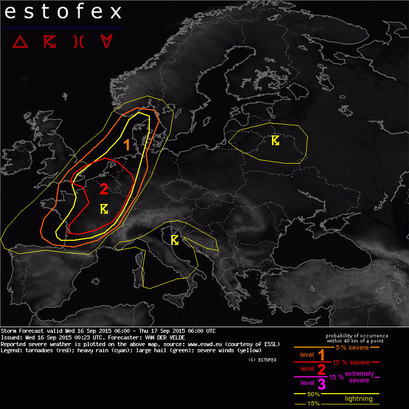


...but if the storm is headed east of the expected path, then that risk will be more of a Kent Clipper, which won't surprise many I'm sure!


If you have any problems or queries relating to TWO you can Email [email protected]

https://twitter.com/peacockreports 
2023's Homeland Extremes:
T-Max: 30.2°C 9th Sep (...!) | T-Min: -7.1°C 22nd & 23rd Jan | Wettest Day: 25.9mm 2nd Nov | Ice Days: 1 (2nd Dec -1.3°C in freezing fog)
Keep Calm and Forecast On
nsrobins
16 September 2015 13:08:10
The trend for an eastward shift looks real now. Areas east of the IOW still at risk from 16Z so long as the skies clear behind the main rain band, but I suspect the deepest convection will be reserved for the far SE. For this reason I will probably not go out but will check again in a few hours.
Currently here it's cold and damp.
Neil
Fareham, Hampshire 28m ASL (near estuary)
Stormchaser, Member TORRO
Rich mt
16 September 2015 13:13:07

That storm West of Dijon is putting out a hell of a lot of lightening at the moment if lightening maps is to be belived!
Poole, Dorset
Stormchaser
16 September 2015 14:28:26

Looks like the rain band is starting to pivot in the vicinity of Weymouth, could be some very high totals for the even down there.


The warmer, muggier side of the band is starting to arrive here now. Seems I'm going to be right on the borderline for a while, with any fun and games here having to develop right on the backside of the boundary.


There is some sheared convection cropping up in the Channel now. Meanwhile the 'popcorn' cells trying to cross the Channel appear to be having a hard time of it despite sea temps being near their highest at this time of year.


If you have any problems or queries relating to TWO you can Email [email protected]

https://twitter.com/peacockreports 
2023's Homeland Extremes:
T-Max: 30.2°C 9th Sep (...!) | T-Min: -7.1°C 22nd & 23rd Jan | Wettest Day: 25.9mm 2nd Nov | Ice Days: 1 (2nd Dec -1.3°C in freezing fog)
Keep Calm and Forecast On
nsrobins
16 September 2015 16:18:55

Well we've got shear at depth here now. Surface NE and a S flow at about 850mb


Wstching this very closely even by my standards!


Neil
Fareham, Hampshire 28m ASL (near estuary)
Stormchaser, Member TORRO
Weathermac
16 September 2015 17:41:34
Completely bone dry here despite being in warning zone been a pretty poor forecast for here .
Girthmeister
16 September 2015 19:50:48
http://www.raintoday.co.uk/  - fairly vicious looking line of activity from Southend to Cherbourg...
idj20
17 September 2015 21:32:04

 Evenin' all. I've just noticed that CAPE levels over Kent are expected to be modest at around afternoon time tomorrow, which is timed with a decaying occluded front moving over us at the same time. 
  So, it seems that while there'll be showers knocking about all day, that much is certain, there is a chance for some of those to get big enough to produce thunder over Kent, especially if there are some sunshine in between to provide solar heating. It does seem that any hail, heavy rain and lightning that does occur are expected to be very localised in nature - but when, where and how they'll form over Kent really is another matter altogether (that random "whack-a-mole" effect)
 The showers & localised thunderstorms are expected to die out by evening time, though, as pressure rises, until then it does look like being a day of interesting cloudscapes tomorrow.


Folkestone Harbour. 
Twister
18 September 2015 15:28:41
Just had a nice thunderstorm pass overhead with 7-8 strikes within half a mile of me. Heavy rain and a little bit of small hail in the heaviest bursts. Now clearing and moving south east.
Location: Egerton, Kent - 33m ASL
Thunder 2016: 12 (Apr 3,13; May 21; Jun 8,11,17,22,23,25, Jul 2,12, Aug 26)
Winter 2015/6: Snowfalls: 10 | Snowcover: 2 (Jan 17 (0.5cm)) | Air frosts: 39
Winter 2016/7: Snowfalls: 4 (Jan 12-3, Feb 10-11) | Snowcover: 2 (Jan 13, 2cm, Feb 11, 3-5mm) | Air frosts: 57 (2 in Oct, 10 in Nov, 13 in Dec, 19 in Jan, 6 in Feb, 3 in Mar, 4 in Apr)
"The heavens tell of the glory of God. The skies display his marvellous craftsmanship." (Psalm 19:1)
Charmhills
18 September 2015 17:20:31

Had a heavy shower just after 3pm this afternoon.


Before that is was overcast to unbroken sunshine until 2pm.


Loughborough, EM.

Knowledge is power, ignorance is weakness.

Duane.
ozone_aurora
19 September 2015 08:51:23

Yesterday, we had absolutely torrential downpours from slow moving showers in the afternoon. However, there was no thunder.

sunny coast
19 September 2015 11:43:24
couple of heavy down pours yesterday pm following 12 mm ovwenight , late pm was thunder and lighning too
idj20
22 September 2015 06:06:14

Woken up to heavy laden skies and it's now pouring down, this could last for an hour or two looking at the radars. I'm glad I'm not having to be dealing with a motorbike commute to a countryside workplace.


Folkestone Harbour. 

Remove ads from site

Ads