Copied over from NW as I know Ian has a resurgent interest in all things stratospheric, and I know Jive Buddy is a long-time admirer.
The last sentence makes a practical lrf for February based on the detail that goes before it.
Tamara 12,604

- Members
- 12,604
- 2,710 posts
- Gender: Female
- Location: Hastings, The Ridge, 130m asl
The final whites of the eyes of the resurgent vortex are now fully in focus of NWP modelling, ahead of eventual programmed momentum transport from Greenland to Siberia after this inauspicious end period of January to start of February timeframe.
Indian Ocean tropical signal is creating another 'noise response', such as it did in December ,over the well fused together ocean/atmosphere Nino base state. The reduced tendency in atmospheric angular momentum from the heady values of recently is temporarily scrubbing some of the massive surfeit of westerly wind anomalies across the Pacific and creating a very pseudo and transient Nina-like synoptic response.
Despite total budget AAM remaining high

Only a very minor subtle shift of jet energy northwards across the US, but magnified greater by the interim strong vortex across Greenland to provide the very uninspiring flat westerly pattern downstream across the Atlantic of the next 10 days or so.
As amplification starts to occur upstream in the Pacific, the net longwave tendency downstream is to retract the heights to our south and over Europe westwards into the Atlantic, and, with recent negative tendency in frictional torques as a manifestation of suppression of relative AAM tendency, this has the effect of beefing up the Azores High.
This process is now well advertised in the 8 to 10 day modelling period.
Frictional torques have now bottomed out, and starting to trend up in recognition of the continuing low frequency Nino signal in the Pacific. This sets the floor limit for relative angular momentum before rising once again


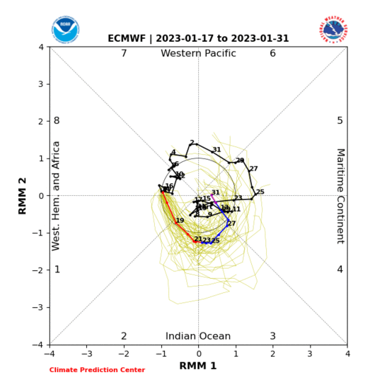
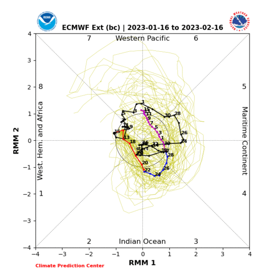
At the same time, the MJO is set to continue its eastwards movement through the Maritimes and then onwards to the Pacific during the course of the first half of February

 .
.
We should be mindful that modelling of this activity beyond a few days will be unreliable, and likely in that respect that progress will be underestimated. This is especially as MJO related activity is usually increasingly active approaching the later winter and then early Spring periods. With displacement and considerable perturbment likely of the stratospheric vortex during the very first part of February, and another round of soaring angular momentum as the MJO arrives at Phases 5 and 6, with the tropical signal increasingly gaining amplitude, then increasing eastward and northward progress of poleward rossby wave activity arrives in the Atlantic as the signal engages the Pacific as it did during this month and associated cold spell.
Nino Region 1.2 (eastern region) continues to cool and assist the evolvement of a traditional later winter Nino cold pattern. With the vortex paying a price for its unwelcome re-staged party gate-crash of our winter, the scene is set for an increasingly amplified Atlantic profile leading to greater and greater blocking potential particularly later in the month. Both the long-wave pattern and Nino forcing look much better accorded to stronger and more defined heights over the NE Atlantic, southern Greenland and Iceland as the month progresses. Better than those seen this month, and with a stronger and more east based NAO profile
It looks good for steadily increasing polar vectors through NW, N and NE through the progress of the month - beginning with polar maritime incursions in the earliest part of the month and becoming progressively colder from there
Edited by user
21 January 2016 20:55:38
|
Reason: Not specified
Dover, 5m asl. Half a mile from the south coast.