Remove ads from site

Gooner
09 November 2020 10:48:04


I ask the same thing every year: What is the ideal set-up for a cold winter in the UK? Whenever we get a mild winter - which let's be honest is most years these days - x, y or z was wrong! Back in the 80s there was a reasonable expectation that most of lowland Britain would see at least some accumulating snow which would hang around for a few days or longer. Surely x, y or z was often "wrong" in some of those years but it didn't prevent decent cold snaps developing.  


Originally Posted by: Brian Gaze 


That's very true Brian and am always asking myself the same question , so what has changed it ? , is it as simple as GW ?


Lets face it all the drivers that Tally has mentioned were around in the 80's , is it that everything went in our favour ?


Remember anything after T120 is really Just For Fun


Marcus
Banbury
North Oxfordshire
378 feet A S L


tallyho_83
09 November 2020 18:53:40

Given the situation that we are in - I suppose we will have to rely on a SSW then like we have done last year and year before last?
We seem to get colder than average winters when we have one of the following weak La Nina's and when we are in an easterly QBO and when there is colder than average SST's in the NE pacific.

Below are the last Average or Colder than average winters.

Winter 08/09
Winter 09/10
Winter 10/11
Winter 12/13 - The year we had a Tripole in the N. Atlantic 
Winter 17/18

All of those winters had one more more of the following above. 1. (Weak La Nina) 2. (Easterly QBO) 3. Colder than average SST's in the NE pacific.

Whilst the winter of 17/18 wasn't that much colder than average and most of the cold came later in the winter - I recall it had all of the 3 above = weak La Nina, easterly QBO and colder than Average SST's in the NE pacific.


Most recent winters esp last few 18/19 and 19/20 we have had none of the above during the winter 


We have had weak El Nino last winter and before. The QBO has been westerly last winter and the winter before (transitioning to westerly). Also winter over past two years has seen not only record breakingly cold stratospheric temperatures but record breaking strong zonal winds at 10hpa and we have NOT seen any cooling of SST's in the NE pacific hence why it's been so mild and or zonal.


Still time for things to change but we all know La Nina favours front loaded winters so given that this November looks exceptionally mild from the models then we had better hope December provides something of interest. Otherwise like last year and the year before we have to rely on a SSW to occur to bring a chance of developing HLB. 


I guess the million dollar question which many don't or may not know the answer to is if the PV is strengthened/enhanced by record breaking cold temperatures in the stratosphere, then what are the causes of these cold stratospheric temperatures every winter? 


Average temperatures should be around -60c at 30hpa and they are currently -75c @ 30hpa!? This is 15c below average and what is the cause of this because it's driving the PV to go into over-drive!? 


(I remember starting a topic on this and the QBO and how it effects out weather patterns earlier in the year).


Home Location - Kellands Lane, Okehampton, Devon (200m ASL)
---------------------------------------
Sean Moon
Magical Moon
www.magical-moon.com


Matty H
09 November 2020 21:35:29
Raging La Niña gives me great confidence of another mild winter! 😃
tallyho_83
09 November 2020 23:29:54

Raging La Niña gives me great confidence of another mild winter! 😃

Originally Posted by: Matty H 


Looks like this winter will be a strong La Nina - I can't remember when it was the last time the UK experienced a winter with a strong/super La Nina!? Can anyone remember or know what year this was and if so how was the winter fair during a strong La Nina?


Home Location - Kellands Lane, Okehampton, Devon (200m ASL)
---------------------------------------
Sean Moon
Magical Moon
www.magical-moon.com


Gandalf The White
10 November 2020 00:31:48


Looks like this winter will be a strong La Nina - I can't remember when it was the last time the UK experienced a winter with a strong/super La Nina!? Can anyone remember or know what year this was and if so how was the winter fair during a strong La Nina?


Originally Posted by: tallyho_83 


Listed here: https://ggweather.com/enso/oni.htm


Location: South Cambridgeshire
130 metres ASL
52.0N 0.1E


picturesareme
10 November 2020 00:49:20


Looks like this winter will be a strong La Nina - I can't remember when it was the last time the UK experienced a winter with a strong/super La Nina!? Can anyone remember or know what year this was and if so how was the winter fair during a strong La Nina?


Originally Posted by: tallyho_83 


Looking at that chart gandolf posted most of the winters with memorable cold spells have been in la nina years.

tallyho_83
10 November 2020 02:02:21


Listed here: https://ggweather.com/enso/oni.htm


Originally Posted by: Gandalf The White 


Thanks Gandalf - Very informative! The strong La Nina which we could be experiencing isn't as rare as I thought and never knew we had it during December 2010. - Which of course was a front loaded winter, which began end of November really.


Home Location - Kellands Lane, Okehampton, Devon (200m ASL)
---------------------------------------
Sean Moon
Magical Moon
www.magical-moon.com


KevBrads1
10 November 2020 07:29:46

This was posted the other day, (at the end of my post) my issue with this. Why would that sunspot group have that much effect? And this is just coming out of a solar minimum. If that were the case, then the chances of a cold winter during a solar maximum and especially an active one would be close to zero.


However, 4 of the coldest winters of the 20th century happened near or at solar maxima: 1916-17, 1928-49, 1946-47, 1978-79


Take a look at these sunspot charts from December 1978....we all know what happened that winter


The tweet


MANCHESTER SUMMER INDEX for 2021: 238
Timelapses, old weather forecasts and natural phenomena videos can be seen on this site
http://www.youtube.com/channel/UCgrSD1BwFz2feWDTydhpEhQ/playlists
Gandalf The White
10 November 2020 08:18:18


This was posted the other day, (at the end of my post) my issue with this. Why would that sunspot group have that much effect? And this is just coming out of a solar minimum. If that were the case, then the chances of a cold winter during a solar maximum and especially an active one would be close to zero.


However, 4 of the coldest winters of the 20th century happened near or at solar maxima: 1916-17, 1928-49, 1946-47, 1978-79


Take a look at these sunspot charts from December 1978....we all know what happened that winter


The tweet


Originally Posted by: KevBrads1 


Surely the point is that the atmosphere is complex with a vast array of interacting forces: no single forcing will determine how the atmosphere behaves.


Location: South Cambridgeshire
130 metres ASL
52.0N 0.1E


Maunder Minimum
10 November 2020 10:10:42


This was posted the other day, (at the end of my post) my issue with this. Why would that sunspot group have that much effect? And this is just coming out of a solar minimum. If that were the case, then the chances of a cold winter during a solar maximum and especially an active one would be close to zero.


However, 4 of the coldest winters of the 20th century happened near or at solar maxima: 1916-17, 1928-49, 1946-47, 1978-79


Take a look at these sunspot charts from December 1978....we all know what happened that winter


The tweet


Originally Posted by: KevBrads1 


Agree completely - utterly bonkers to suggest a single sunspot group at the end of a long and deep solar minimum could have any discernable impact on weather patterns. Solar activity (or lack of it) takes a long time to filter into climatic consequences for terrestrial weather, if there is any impact at all. If we manage to get a repeat of 2010-11 this winter, it would maybe indicate a pattern on emerging from a long and deep solar minimum.


New world order coming.
Gooner
10 November 2020 14:29:09


J F F Lets brighten the mood ..................if only 


Remember anything after T120 is really Just For Fun


Marcus
Banbury
North Oxfordshire
378 feet A S L


tallyho_83
10 November 2020 19:13:16


Agree completely - utterly bonkers to suggest a single sunspot group at the end of a long and deep solar minimum could have any discernable impact on weather patterns. Solar activity (or lack of it) takes a long time to filter into climatic consequences for terrestrial weather, if there is any impact at all. If we manage to get a repeat of 2010-11 this winter, it would maybe indicate a pattern on emerging from a long and deep solar minimum.


Originally Posted by: Maunder Minimum 


I disagree with solar min = colder winters and solar max - milder etc - Last year we were at solar minimum and it made no difference at all to the weather we had during the winter of 19/20 - same goes for winter of 2018/19 when we were going towards solar minimum.


Home Location - Kellands Lane, Okehampton, Devon (200m ASL)
---------------------------------------
Sean Moon
Magical Moon
www.magical-moon.com


doctormog
10 November 2020 19:15:55


I disagree with solar min = colder winters and solar max - milder etc - Last year we were at solar minimum and it made no difference at all to the weather we had during the winter of 19/20 - same goes for winter of 2018/19 when we were going towards solar minimum.


Originally Posted by: tallyho_83 


Have a read through this study (or at least the abstract). It makes interesting reading https://agupubs.onlinelibrary.wiley.com/doi/full/10.1002/2013JD020062 


Tim A
11 November 2020 09:42:13
Realistically, the best chance of snow in December this year (and most years) is from cold PM shots/cold zonality or a stray southern tracking low. The vast majority of the December snowfall I can remember has come in this way, Dec 2009 and 2010 the exception.

Tim
NW Leeds
187m asl

 My PWS 
Gandalf The White
11 November 2020 09:49:46


I disagree with solar min = colder winters and solar max - milder etc - Last year we were at solar minimum and it made no difference at all to the weather we had during the winter of 19/20 - same goes for winter of 2018/19 when we were going towards solar minimum.


Originally Posted by: tallyho_83 


Except that's not accurate. The period around the solar minimum increases the chances of colder winters.  That's a very long way from what you've said.


Location: South Cambridgeshire
130 metres ASL
52.0N 0.1E


tallyho_83
11 November 2020 10:21:00


J F F Lets brighten the mood ..................if only 


Originally Posted by: Gooner 


Re the QBO. 


https://acd-ext.gsfc.nasa.gov/Data_services/met/qbo/qbo.html


Home Location - Kellands Lane, Okehampton, Devon (200m ASL)
---------------------------------------
Sean Moon
Magical Moon
www.magical-moon.com


Shropshire
15 November 2020 09:03:43

This has been a pretty good indicator for the US in recent years -


https://weather.com/forecast/national/news/2020-11-10-winter-outlook-forecast-temperatures-united-states


It suggests the familar pattern of the jet at Northern latitudes, a strongly +ve NAO and a mild/very mild winter. The downstream reflection of this US forecast was issued by GLOSEA the other day.


The most significant factor this year is the strenghthening central based La Nina which correlates strongly with zonality for Europe especially from mid-winter onwards. Not that the myriad of indicators should be looked into too deeply or pattern matched prior to the late eighties in any great detail. What we know/should expect - 


  • In the modern era so called favourable indicators can be overwritten by the sheer persistence of pattern that we have become familiar with.

  • With the overall warming trend and an unfavourable set of background factors, flooding/temperature records are likely to be broken somewhere at some stage. My punt would be for the warmest January on record.

  • The GLOSEA forecast in particular (though supported by others anyway) cannot be overlooked as seasonal forecasting from the big boys has improved markedly over recent years.

  • Needless to say, the 24 years without a mid winter easterly will be becoming 25.


From December 27th 2020, zonality will be banned from mixing with the UK. We appreciate that this may come as a shock to younger people and old Uncle Barty. This ban will last for a minimum of ten days.
tallyho_83
15 November 2020 10:43:02


This has been a pretty good indicator for the US in recent years -


https://weather.com/forecast/national/news/2020-11-10-winter-outlook-forecast-temperatures-united-states


It suggests the familar pattern of the jet at Northern latitudes, a strongly +ve NAO and a mild/very mild winter. The downstream reflection of this US forecast was issued by GLOSEA the other day.


The most significant factor this year is the strenghthening central based La Nina which correlates strongly with zonality for Europe especially from mid-winter onwards. Not that the myriad of indicators should be looked into too deeply or pattern matched prior to the late eighties in any great detail. What we know/should expect - 


  • In the modern era so called favourable indicators can be overwritten by the sheer persistence of pattern that we have become familiar with.

  • With the overall warming trend and an unfavourable set of background factors, flooding/temperature records are likely to be broken somewhere at some stage. My punt would be for the warmest January on record.

  • The GLOSEA forecast in particular (though supported by others anyway) cannot be overlooked as seasonal forecasting from the big boys has improved markedly over recent years.

  • Needless to say, the 24 years without a mid winter easterly will be becoming 25.


Originally Posted by: Shropshire 


Quite - we can't win really can' we!?


Regardless of what the situation beit ENSO region in pacific is at/Solar Minimum/SST's in the IOD or QBO state etc! We will always get a milder than average winter. OI have given up and it's only middle of November. I thought things couldn't get worse for cold and snowy winter weather lovers than it did last winter and there as me thinking the winter 18/19 was bad until last winter 19/20 when we had a record strong PV of doom from start to finish as well as record breakingly strong zonal winds. I then thought to myself - this winter couldn't get worse than last winter knowing that there was no severe cold weather anywhere except the Arctic regions like N Canada and maybe Alaska - most of if not all parts of the N Hemisphere saw temperatures well above average for the whole 3 months. Moscow on XMas eve reached a dizzy high of +10c and they needed Artificial snow. NYC recorded a max snow depth of "4.2" of snow - this was throughout the whole of the winter 19/20. The whole of the 3 months saw only "4.2" of snow which fell in NYC.


It has to be global warming and we must look at the wider picture! As everything goes against a colder winter we again need to rely on a SSW yet again. - However even this won't guarantee us cold weather. The winter of 18/19 proved this correctly.


Home Location - Kellands Lane, Okehampton, Devon (200m ASL)
---------------------------------------
Sean Moon
Magical Moon
www.magical-moon.com


tallyho_83
15 November 2020 12:38:14

Interesting pattern for December from CFS today but could look totally different tomorrow:


Home Location - Kellands Lane, Okehampton, Devon (200m ASL)
---------------------------------------
Sean Moon
Magical Moon
www.magical-moon.com


Shropshire
15 November 2020 14:33:03


I ask the same thing every year: What is the ideal set-up for a cold winter in the UK? Whenever we get a mild winter - which let's be honest is most years these days - x, y or z was wrong! Back in the 80s there was a reasonable expectation that most of lowland Britain would see at least some accumulating snow which would hang around for a few days or longer. Surely x, y or z was often "wrong" in some of those years but it didn't prevent decent cold snaps developing.  


Originally Posted by: Brian Gaze 


Exactly this. We hear about the ENSO,PNA,SSTs, AO,NAO,GLAAM, MJO, QBO, Solar activity, the Indian Dipole etc...and how if one of these is against us then it's bad news for us. How could they ALL of have aligned perfectly again and again all those years ago ? 


From December 27th 2020, zonality will be banned from mixing with the UK. We appreciate that this may come as a shock to younger people and old Uncle Barty. This ban will last for a minimum of ten days.
Retron
15 November 2020 14:45:01


Exactly this. We hear about the ENSO,PNA,SSTs, AO,NAO,GLAAM, MJO, QBO, Solar activity, the Indian Dipole etc...and how if one of these is against us then it's bad news for us. How could they ALL of have aligned perfectly again and again all those years ago ? 


Originally Posted by: Shropshire 


The answer: they didn't. There was enough leeway in the system such that even a near miss delivered. Northerlies were that much colder, for example, and colder air (with the sun being the same strength as ever) means more convection, more "oomph", heavier and more widespread showers.


The longer answer: the lack of midwinter easterlies is what's starved many of the sort of snow we had in the 80s (and into the 90s). The kind of self-reinforcing block which repels the Atlantic for more than a day or three. The last time we saw one of those self-reinfocing blocks was at the end of February 2005, which delivered a fortnight of snow in some areas - but it was just a bit too warm by then to do much. The tail end of Feb 2018 showed that we can, if things align, still get decent ice days, powder snow etc, even down here...


...but the problem is instead of hitting the dartboard at all (60s), or getting within a couple of inches of the bullseye being enough (80s), we're now aiming at a shrunken bullseye... meaning it's much, much harder.


Whether it's something which is on a "sine wave" oscillation, or whether we've seen a step change, remains to be seen.


Leysdown, north Kent
Retron
15 November 2020 14:47:46
Incidentally, for those keeping track of such things, there is a glimmer of hope from the ECM zonal wind forecasts. It flipped over a month ago to a generally stronger zonal flow, but the latest run shows some tantalising scenarios at the end...

https://apps.ecmwf.int/webapps/opencharts/products/extended-zonal-mean-zonal-wind?area=nh&base_time=202011120000 

Leysdown, north Kent
tallyho_83
15 November 2020 14:59:44


Exactly this. We hear about the ENSO,PNA,SSTs, AO,NAO,GLAAM, MJO, QBO, Solar activity, the Indian Dipole etc...and how if one of these is against us then it's bad news for us. How could they ALL of have aligned perfectly again and again all those years ago ? 


Originally Posted by: Shropshire 


Exactly many years ago - say 90's for exception of Feb 1998, we always had proper cold spells every winter beit a northerly or an easterly at some point regardless of what state the ARCTIC SEA ICE, SIBERIAN SNOW COVER, HURRICANE SEASON, ENSO,PNA,SSTs, AO,NAO,GLAAM, MJO, QBO, Solar activity, the Indian Dipole was in etc was in/at. Past few winters have failed to provide anything cold!? We have to rely on a SSW to get cold weather and even that wasn't guaranteed. The cold spell end of Feb 2018 was cause by a SSW - but that winter 17/18 was not that much colder than average (not for the south anyway!). The Severe cold and wintry December 2010 occurred without a SSW as well. Since then we have really struggled to get decent cold wintry blast with ice days and daytime maxes of 0c with frost lingering all day!? When was the last time we had a mid winter easterly or a potent cold northerly wind giving us penetrating frost and snow lasting more than 5 days in a row!?


It certainly was a while ago that's for sure. As I have mentioned before the temperatures in the stratosphere (between 10hpa and 30hpa) over past few winters have been significantly below than average and this has coincided with a strengthened polar vortex and if this is the case then what's causing these abnormally cold stratospheric temperatures? Is this global warming? Is GW responsible for the cooling of the temperatures in the stratosphere!? The temperatures at 30hpa are around -76c and the average should be -60c. My point is that if we continue to have well below average temperatures in the stratosphere, then surely this overrides everything else and goes against having a colder winter full STOP!? 


If this is correct them my thought would be (ideally) for a cold winter we would want to see stratospheric temperatures at or above average for any chance of having a blocking or colder weather!? Last winter we saw the stratospheric temperatures remain substantially colder than average throughout hence PV of doom and no cold spells!?


But these are my thoughts - what are your thoughts on this!?


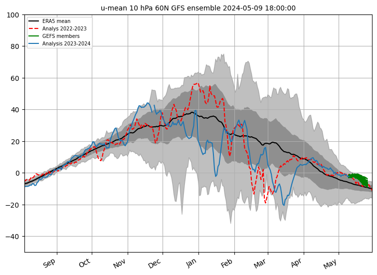
Meanwhile the strength of the zonal westerlies @ 10hpa look like going record breaking strong judging by all GEFS models! - All thanks to a cold stratospheric temperatures and a strengthening of the PV. - We can also see how positive the strength of the zonal winds were and at times how record breaking positive last winter 19/20 was. (Right from the first day of winter) - we never went average or weaker than average throughout the whole 3 months of the winter strangely! 

No description available.


Home Location - Kellands Lane, Okehampton, Devon (200m ASL)
---------------------------------------
Sean Moon
Magical Moon
www.magical-moon.com


tallyho_83
15 November 2020 15:22:03


Exactly many years ago - say 90's for exception of Feb 1998, we always had proper cold spells every winter beit a northerly or an easterly at some point regardless of what state the ARCTIC SEA ICE, SIBERIAN SNOW COVER, HURRICANE SEASON, ENSO,PNA,SSTs, AO,NAO,GLAAM, MJO, QBO, Solar activity, the Indian Dipole was in etc was in/at. Past few winters have failed to provide anything cold!? We have to rely on a SSW to get cold weather and even that wasn't guaranteed. The cold spell end of Feb 2018 was cause by a SSW - but that winter 17/18 was not that much colder than average (not for the south anyway!). The Severe cold and wintry December 2010 occurred without a SSW as well. Since then we have really struggled to get decent cold wintry blast with ice days and daytime maxes of 0c with frost lingering all day!? When was the last time we had a mid winter easterly or a potent cold northerly wind giving us penetrating frost and snow lasting more than 5 days in a row!?


It certainly was a while ago that's for sure. As I have mentioned before the temperatures in the stratosphere (between 10hpa and 30hpa) over past few winters have been significantly below than average and this has coincided with a strengthened polar vortex and if this is the case then what's causing these abnormally cold stratospheric temperatures? Is this global warming? Is GW responsible for the cooling of the temperatures in the stratosphere!? The temperatures at 30hpa are around -76c and the average should be -60c. My point is that if we continue to have well below average temperatures in the stratosphere, then surely this overrides everything else and goes against having a colder winter full STOP!? 


If this is correct them my thought would be (ideally) for a cold winter we would want to see stratospheric temperatures at or above average for any chance of having a blocking or colder weather!? Last winter we saw the stratospheric temperatures remain substantially colder than average throughout hence PV of doom and no cold spells!?


But these are my thoughts - what are your thoughts on this!?


Meanwhile the strength of the zonal westerlies @ 10hpa look like going record breaking strong judging by all GEFS models! - All thanks to a cold stratospheric temperature and a strengthening of the PV. - We can also see how positive the strength of the zonal winds were and at times how record breaking positive last winter 19/20 was. (Right from the first day of winter) - we never went average or weaker than average throughout the whole 3 months of the winter strangely! 


No description available.


Originally Posted by: tallyho_83 


It's like the cause of the big bang!? What's the cause of the big bang..? If that's the cause of the Big Bang then what's the cause of the cause of the 'big bang!?'


Home Location - Kellands Lane, Okehampton, Devon (200m ASL)
---------------------------------------
Sean Moon
Magical Moon
www.magical-moon.com


Gooner
15 November 2020 16:26:35

Incidentally, for those keeping track of such things, there is a glimmer of hope from the ECM zonal wind forecasts. It flipped over a month ago to a generally stronger zonal flow, but the latest run shows some tantalising scenarios at the end...

https://apps.ecmwf.int/webapps/opencharts/products/extended-zonal-mean-zonal-wind?area=nh&base_time=202011120000

Originally Posted by: Retron 


That's a bit of a change ...............glimmer of hope 


Remember anything after T120 is really Just For Fun


Marcus
Banbury
North Oxfordshire
378 feet A S L


Remove ads from site

Ads