Remove ads from site

tallyho_83
05 December 2014 21:55:27


Hmm indeed, I wonder why the BBC have not mentioned the GFS 12z operational run chart's low resolution t2m output 15 days in advance. 


Originally Posted by: doctormog 


Well looking at the 12z charts the Met Office daily outlook updates has said everything but mild, yet the GFS all point towards some very mild weather especially for the south? I do wonder?!


Home Location - Kellands Lane, Okehampton, Devon (200m ASL)
---------------------------------------
Sean Moon
Magical Moon
www.magical-moon.com


Gooner
05 December 2014 22:18:17


How come this hasn't been backed up by the Met Office or BBC!"??


Originally Posted by: tallyho_83 


Are you serious Tally???


Remember anything after T120 is really Just For Fun


Marcus
Banbury
North Oxfordshire
378 feet A S L


Polar Low
05 December 2014 22:37:01

Perhaps the key is sending the Canadian trough to its negative phase sooner thus giving the ridge more time and space to do its work does appear to be a a small jet streak near the base which would be a classic sighn hopeful filling will continue


Thanks ever so much James for post


quote=Stormchaser;649067]


Very close to walling off the Canadian trough on the ECM run. The transition across Greenland still occurs but it's at day 7 so nothing nailed on yet either way.


Even with the transfer, the mid-Atlantic ridge proves sufficient for a sharply digging trough days 9-10, in fact so much so that there's room for the ridge to build over the top of the trough in the North Sea as it drops south, particularly given that the jet is also digging well south in the western North Atlantic.


Apart from GFS being flatter in the Atlantic as usual, the day 10 N. Hem profiles are actually quite similar as far as the major features go.


If I have my theory right, the stronger Siberian High and deeper Aleutian low on the ECM run should bring about even more strat. warming than the GFS run developed.


I figure the MJO is worth a look again today. Clearly UKMO and JMAN have trended towards the ECMF solution, but by contrast the ECMF solution now takees the MJO to phase 8 and it almost hits the amplitude of around 1.0 beyond which the atmospheric response tends to be much stronger. There's then a brief, weak venture into phase 1, after which it does head into phase 4 and amplifies, but by that time phase 4 is less detrimental to blocking to the NW (it actually favours it come January).


This, too, should encourage even more promising strat. developments in the extended ECM.


GEFS is being stubborn with the higher amplitude MJO but at the moment a meeting in the middle ground looks plausible. That would actually be fairly good going.
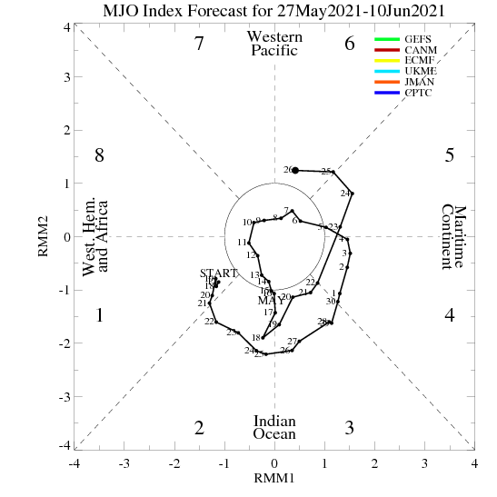


While basking in waves of positive developments this evening, I do wonder if this apparently smooth track might actually turn out to be a roller coaster as it so often does... but there's no denying that today's trends are the most encouraging of the past month or so 


Andy Woodcock
05 December 2014 22:42:25
GFS 18z keeps the cool zonal pattern out to +240 and is more amplified at that time than the 12z.

A very unsettled and windy spell coming up with lots of snow for higher areas in the north, the Scottish ski resorts will be passing the whiskey around with these latest runs as another bumper season beckons (remember all those predictions a few years ago about the end of Scottish skiing lol)

Snowfall lower down seems more problematic even up north as temperatures seem a bit too high but at this range it's difficult to be sure and subject to change.

No sign of Northern blocking but no sign of a Bartlett either so I have known a lot worse starts to winter.

Andy
Andy Woodcock
Penrith
Cumbria

Altitude 535 feet

"Why are the British so worried about climate change? Any change to their climate can only be an improvement" John Daley 2001
Polar Low
05 December 2014 23:03:58

And now gfs has given its self a problem as the 1st time what will it do with that energy this time does it do the same  is it a repeating type winter pattern??


http://www.meteociel.fr/modeles/gfse_cartes.php?&ech=132&mode=0&carte=1


http://www.meteociel.fr/modeles/gfse_cartes.php?&ech=240&mode=0&carte=1


David M Porter
05 December 2014 23:11:22

GFS 18z keeps the cool zonal pattern out to +240 and is more amplified at that time than the 12z.

A very unsettled and windy spell coming up with lots of snow for higher areas in the north, the Scottish ski resorts will be passing the whiskey around with these latest runs as another bumper season beckons (remember all those predictions a few years ago about the end of Scottish skiing lol)

Snowfall lower down seems more problematic even up north as temperatures seem a bit too high but at this range it's difficult to be sure and subject to change.

No sign of Northern blocking but no sign of a Bartlett either so I have known a lot worse starts to winter.

Andy


Originally Posted by: Andy Woodcock 


Agree totally with your last sentence there, Andy. The charts we were starting to see around this time last December were from what I remember quite a bit worse from a cold perspective than those we have at the moment.


Let's hope the reasonably positive trend in the models is maintained over the weekend.


Lenzie, Glasgow

"Let us not take ourselves too seriously. None of us has a monopoly on wisdom, and we must always be ready to listen and respect other points of view."- Queen Elizabeth II 1926-2022
Polar Low
05 December 2014 23:22:00

Depends on what model you look at the japs have rather a different solution plenty of blocking going on there David


http://www.meteociel.fr/modeles/jma.php?ech=132&mode=1&nh=1&archive=0


http://www.meteociel.fr/modeles/jma.php?ech=192&mode=1&nh=1&archive=0


Agree totally with your last sentence there, Andy. The charts we were starting to see around this time last December were from what I remember quite a bit worse from a cold perspective than those we have at the moment.


Let's hope the reasonably positive trend in the models is maintained over the weekend.


Originally Posted by: David M Porter 

Gooner
05 December 2014 23:54:26

http://modeles.meteociel.fr/modeles/gfs/runs/2014120518/gfsnh-10-384.png?18


Warming continues in FI


Remember anything after T120 is really Just For Fun


Marcus
Banbury
North Oxfordshire
378 feet A S L


Quantum
06 December 2014 00:27:08

An SSW event on the southern tip of greenland is the best type for us.


2023/2024 Snow days (approx 850hpa temp):
29/11 (-6), 30/11 (-6), 02/12 (-5), 03/12 (-5), 04/12 (-3), 16/01 (-3), 18/01 (-8), 08/02 (-5)

Total: 8 days with snow/sleet falling.

2022/2023 Snow days (approx 850hpa temp):

18/12 (-1), 06/03 (-6), 08/03 (-8), 09/03 (-6), 10/03 (-8), 11/03 (-5), 14/03 (-6)

Total: 7 days with snow/sleet falling.

2021/2022 Snow days (approx 850hpa temp):

26/11 (-5), 27/11 (-7), 28/11 (-6), 02/12 (-6), 06/01 (-5), 07/01 (-6), 06/02 (-5), 19/02 (-5), 24/02 (-7), 30/03 (-7), 31/03 (-8), 01/04 (-8)
Total: 12 days with snow/sleet falling.
nsrobins
06 December 2014 07:17:04

Things remain just as they were - mobile, changeable pM conditions with brief more northerly incursions. Despite some excitement and posts about lake-effect thundersnow, I cant see anything in the way of significant lowland snowfall at it stands. Again elevation and the ski resorts will do very well next week.


And again some of the information and detail in here is excellent. One question though, I'm not sure how we got to the situation where surface features 'cause' Strat warming? I thought SLP was as removed from events in the 1 - 5mb layer as they can be - miles apart literally. Yes I understand how an SSW can propagate down with time and possibly influence surface patterns, but how does it work the other way around?


Neil
Fareham, Hampshire 28m ASL (near estuary)
Stormchaser, Member TORRO
idj20
06 December 2014 07:38:47

What a huge pressure gradient on Tuesday, going from a strong 1041 mb Azores high to a bombing 933 mb low off Greenland across a relatively short distance.

http://www.wetterzentrale.de/pics/brack3.gif

At least this time round the low pressure centre is more closer to Iceland (a classic "Icelandic" feature) rather than off to the north west of the UK like they kept doing last year.


Folkestone Harbour. 
Whether Idle
06 December 2014 07:41:23


Things remain just as they were - mobile, changeable pM conditions with brief more northerly incursions. Despite some excitement and posts about lake-effect thundersnow, I cant see anything in the way of significant lowland snowfall at it stands. Again elevation and the ski resorts will do very well next week.


Originally Posted by: nsrobins 


There is also agreement from the models that the weather does get less pM influenced after next weekend as the Azores high re asserts itself to our SW.  


As for SSWs, what I will usefully add is that last winter there were acres of cyberspace devoted to blinkered almost devout convictions that the SSWs that were being modelled would create cold weather in the UK.  We ended up frostless snowless and wettest. lol.  In 'another place' on the web there are some self styled high priests of SSWs whose intolerance of any questioning of their declarations and predictions are treated with scorn and contempt. Here on TWO we do seem to be able to gave a bit more tolerance and open minded ness at times, which to my way of thinking is entirely correct.


Dover, 5m asl. Half a mile from the south coast.
Brian Gaze
06 December 2014 07:52:58

Long way off, but for those of us in the south Thurs and Fri look worth watching.


http://www.theweatheroutlook.com/twodata/datmdlout.aspx


Brian Gaze
Berkhamsted
TWO Buzz - get the latest news and views 
"I'm not socialist, I know that. I don't believe in sharing my money." - Gary Numan
doctormog
06 December 2014 07:57:57


There is also agreement from the models that the weather does get less pM influenced after next weekend as the Azores high re asserts itself to our SW.  


Originally Posted by: Whether Idle 


A week is a long time in weather terms and before then there are some very interesting synoptics especially but not exclusively for the NW. Some could see quite a bit of wintry weather and as others have mentioned the mountain up here look like getting significant snowfall which could be nice timing for the Christmas period if the conditions stay seasonal (i.e. not mild, wet and windy)


There seems to be more wintry potential in the current outlook than at any stage last "winter" not that that is saying much!


Justin W
06 December 2014 07:59:45


 As for SSWs, what I will usefully add is that last winter there were acres of cyberspace devoted to blinkered almost devout convictions that the SSWs that were being modelled would create cold weather in the UK.  We ended up frostless snowless and wettest. lol.  In 'another place' on the web there are some self styled high priests of SSWs whose intolerance of any questioning of their declarations and predictions are treated with scorn and contempt. Here on TWO we do seem to be able to gave a bit more tolerance and open minded ness at times, which to my way of thinking is entirely correct.


Originally Posted by: Whether Idle 


It's the same every year - straws and clutching. SSWs last year and the OPI this. And because the OPI has failed to deliver so far everybody is falling back on SSWs.


I've been here long enough to know that there is no holy grail when it comes to a significant cold spell in this country.


Meanwhile, I can't see anything to get excited about for the next 10 days although we have managed a frost this morning!


Yo yo yo. 148-3 to the 3 to the 6 to the 9, representing the ABQ, what up, biatch?
Whether Idle
06 December 2014 08:36:59


A week is a long time in weather terms and before then there are some very interesting synoptics especially but not exclusively for the NW. Some could see quite a bit of wintry weather and as others have mentioned the mountain up here look like getting significant snowfall which could be nice timing for the Christmas period if the conditions stay seasonal (i.e. not mild, wet and windy)


There seems to be more wintry potential in the current outlook than at any stage last "winter" not that that is saying much!


Originally Posted by: doctormog 


Correct.  I'm looking forward to an interesting 9 or so days of " seasonal" pM weather redolent of the Late 1970s and early 1980s winters.  Twill be good for northwestern areas with good altitude.


Dover, 5m asl. Half a mile from the south coast.
Solar Cycles
06 December 2014 08:56:19


It's the same every year - straws and clutching. SSWs last year and the OPI this. And because the OPI has failed to deliver so far everybody is falling back on SSWs.


I've been here long enough to know that there is no holy grail when it comes to a significant cold spell in this country.


Meanwhile, I can't see anything to get excited about for the next 10 days although we have managed a frost this morning!


Originally Posted by: Justin W 

Remind me again on the date, so now we've checked our calendar remind me again how any theory has failed. 

GIBBY
06 December 2014 09:01:10

HERE IS MY LATEST ANALYSIS FROM THE OUTPUTS OF THE WEATHER COMPUTER PREDICTION MODELS FOR TWO WEEKS FROM 8AM TODAY SATURDAY DECEMBER 6TH 2014.

NEXT UPDATE SUNDAY DECEMBER 7TH 08:00

THE CURRENT GENERAL SITUATION
A cold front will move down over the UK from the NW later today and tomorrow followed by a cold and showery WNW flow.

MODELS-2 WEEK HEADLINE Rather cold and windy for most with wintry showers or longer spells of rain or sleet with snow on hills especially in the North. Some night frosts where skies clear.

THE JET STREAM ENSEMBLE FORECAST The Jet Stream Ensemble forecast shows the flow positioned to the South of the UK with cold zonal weather the most likely with rain or showers for all falling as sleet and snow at times in bluster west or NW winds.

GFS OPERATIONAL The GFS operational this morning shows a lot of rather cold and unsettled weather across the UK as the pattern of Low to the North and occasionally NW and NE and High to the SW persists. There is spells of wet and windy weather shown for all at times followed by spells of colder and clearer weather with wintry showers across the North and West in particular. It is shown to be often windy too.

THE GFS PARALLEL RUN The GFS Parallel run is not available until Monday of next week.

THE GFS CONTROL The GFS control run maintains a similar pattern to the operational with winds from a Westerly point alternating with more NW or even North winds at times as each weather system moves away East. Occasional rain followed by wintry showers will be a repeated process through the run with snow at times over most high ground.

THE GEFS ENSEMBLES The GEFS Ensembles maintain a period of zonal Westerly winds over the next two weeks circulating around Low pressure to the North and High to the South. As a lot of colder air interjects at times there will be wintry showery type weather for many areas too with frost and snow at times over even modest high ground on occasion.

UKMO UKMO today shows deep Low pressure to the North of the UK with a strong, cold and unstable Westerly flow over the UK. Showers or longer spells of rain with sleet and snow at times over high ground look the most likely scenario for all areas later next week.

THE FAX CHARTS The Fax Charts show a cold front moving SE across the UK tonight and again towards midweek, each accompanied by strong winds cloud and rain. In between will be a cold and showery WNW flow particularly later in the period with some frost by night early in the week as a ridge topples across the UK from the West.

GEM GEM this morning shows a very unsettled and cold period next week as a deep Low crosses East to the North of Scotland and then SE down over NW Europe tutning winds into the NW or North with wintry showers and strong winds for many as a result. Later in the run pressure is shown to rise markedly as a ridge moves across from the West with widespread frost before milder Westerly winds cross the UK from the Atlantic later with rain at times.

NAVGEM NAVGEM also shows strong Westerly winds developing through next week and once a band of squally rain moves through cold and showery conditions will prevail and as winds turn more NW later in the week wintry showers across Northern and Western hills could extend to all areas later.

ECM ECM this morning shows a variation on the same theme as the others with a chilly and unstable WNW flow across the UK following the band of squally rain towards midweek. Troughs in the flow enhance the showers at times before winds turn more NW later and rising pressure from the SW dampens down the showers from the SW late in the period. Many of the showers will be wintry especially on higher ground and this may extend to lower levels too at times especially later in the week and next weekend.

ECM ENSEMBLES This morning's Ensemble data maintains the pattern of Low tpressure to the North and High near the Azores but this is made up of a variation of options some of which do include Northerly incursions with snow showers in places and others with a milder Westerly pattern with rain at times so clearly nothing definitive can be drawn from these this morning.

NOTABLE TREND CHANGES FROM PREVIOUS RUNS The main theme is for a lot of rather cold zonal Westerly winds to prevail across the UK between deep Low pressure to the North and High pressure near the Azores with the usual ebbs and flows in the flow as each weather system passes to the North.

MY THOUGHTS The pattern most commonplace within all the output this morning is for a sustained period of rather cold and unstable, strong Westerly winds to blow across the UK over the next couple of weeks. With the air source often coming from Newfoundland or Greenland the air will be none to warm at times and with sufficient instability in the form of showers there will be loads of wintry showers peppering our Northern and Western areas in particular driven well inland at times in the strong flow. There could also be minor disturbances within the flow delivering more prolonged rain or sleet at times too and with time the flow could tilt more NW or even North which will enhance the wintriness within the showers to even more areas at even modest height levels later. However, the distribution of showers will shift more towards the North and sheltered Southern and pater Western areas would see less showers and possible frosty nights as pressure rises somewhat from the SW. So having dealt with the pattern of the next few weeks where will that leave us as we approach Christmas. Well I still feel as yesterday that it's too the North we have to continue to look for our cold weather this side of the New Year and I'm fairly certain that there will be some interesting weather not too dissimilar to the pattern we are looking towards currently to maintain at least the interest and possibility of snow over the Christmas week and nowhere over the UK could be immune. I do feel though that it will be made up of fleeting snowfalls chiefly over the hills and lying snowfall may well be very temporary at best on low ground and in the South but if our friend the Azores High is allowed to ridge North over the Atlantic at some point over the next few weeks as others on here I wouldn't be surprised to see a plunge into a more sustained and UK wide cold shot from the North develop but for the moment I think the current expected pattern shown for later next week could stick around for quite a while. Having said that it is at least a more seasonal outlook than the benign mild weather with High pressure over Europe than we endured a few weeks back.


Martin G
Kilmersdon Radstock Bath Somerset


Look up my New Facebook Weather Page  for all the latest up to the minute weather stories as they happen
David M Porter
06 December 2014 09:36:23


A week is a long time in weather terms and before then there are some very interesting synoptics especially but not exclusively for the NW. Some could see quite a bit of wintry weather and as others have mentioned the mountain up here look like getting significant snowfall which could be nice timing for the Christmas period if the conditions stay seasonal (i.e. not mild, wet and windy)


There seems to be more wintry potential in the current outlook than at any stage last "winter" not that that is saying much!


Originally Posted by: doctormog 


Indeed Michael.


Looking at the output at the moment reminds me in some ways of looking at archive charts for a famously cold and zonal month; January 1984. AFAIK most parts of southern Britain didn't seem much snowfall that month but up here there was a lot of it. Glasgow I believe saw numerous days that month that had snowfall, and some of it pretty heavy as well.


Lenzie, Glasgow

"Let us not take ourselves too seriously. None of us has a monopoly on wisdom, and we must always be ready to listen and respect other points of view."- Queen Elizabeth II 1926-2022
Solar Cycles
06 December 2014 09:43:09


Indeed Michael.


Looking at the output at the moment reminds me in some ways of looking at archive charts for a famously cold and zonal month; January 1984. AFAIK most parts of southern Britain didn't seem much snowfall that month but up here there was a lot of it. Glasgow I believe saw numerous days that month that had snowfall, and some of it pretty heavy as well.


Originally Posted by: David M Porter 

Same here David, I recorded 10" of snow that month and I'll take that sort of set up over any of the bobbins Easterlies that many here crave for.

tallyho_83
06 December 2014 10:53:15
Low doesn't sink far south enough!?? - Dam Atlantic high!?

http://www.wetterzentrale.de/pics/Rtavn3361.gif 

Home Location - Kellands Lane, Okehampton, Devon (200m ASL)
---------------------------------------
Sean Moon
Magical Moon
www.magical-moon.com


Hippydave
06 December 2014 11:08:02

Yesterdays milder zonal signal seems to have been muted somewhat in the GFS ens this morning.


http://www.theweatheroutlook.com/charts/gefs/gefsens850London0.png 


Quite an interesting little cooler cluster showing now until around the 18th where the scatter goes milder again.


Similar picture oop North:-


http://www.theweatheroutlook.com/charts/gefs/gefsens850Aberdeen0.png 


With a slightly less pronounced mildness at the end and more cooler options. Should be good for the ski slopes.


With ECM and UKM also showing the near and mid term cool weather, it'll certainly feel like winter, rather than perpetual autumn


Home: Tunbridge Wells
Work: Tonbridge
Nick2373
06 December 2014 11:09:13


Thunderstorms with snow? I believe that thunder can indeed occur with snow but I don't recall experience it in my lifetime.


Originally Posted by: David M Porter 


Morning DMP' I've seen lighting before it started snowing' i was out with my wife clubbing in a town called Port Talbot South Wales,


it was around 3:00am in the moring as we had all just left the club. i renbember it being frezzeing and with it being that cold i was quite shocked to see the lighting within five minutes it was snowing and pretty hard to.

Remove ads from site

Ads