Remove ads from site

Gooner
03 January 2015 09:44:02

Ensembles nice this morning with a definite trend to something colder into week 3 some real corkers in there with Northern blocking! Are we finally slowly going to see the tables turn I wonder.

Originally Posted by: Frostbite80 


Been hinting at a change around mid month last couple of runs, worth keeping an eye on


Remember anything after T120 is really Just For Fun


Marcus
Banbury
North Oxfordshire
378 feet A S L


Fothergill
03 January 2015 10:31:03

Certainly continued tentative signs of a change in the 3rd week of Jan. 00z GEFS anomalies day 14


The NAEFS and GEM are less impressive though


Probably worth waiting until we get into the day 10 timeframe before getting too bothered.


Nearer to the present a nasty storm showing on the UKMO


So zonal express for the next 12 days at least with the chance of stormy weather in the North, then weak hints of a change to a more meridional pattern with the chance of getting some cold air from the North but very tentative ATM.

Gooner
03 January 2015 10:40:52

http://www.wetterzentrale.de/pics/Rtavn3481.gif


FI yes


Just need the HP to shoot up to Greenland , certainly seeing hints of a change mid month


Remember anything after T120 is really Just For Fun


Marcus
Banbury
North Oxfordshire
378 feet A S L


Gooner
03 January 2015 10:43:14

http://www.wetterzentrale.de/pics/Rtavn3601.gif


Wintry from the NE


http://www.wetterzentrale.de/pics/Rtavn36017.gif


http://www.wetterzentrale.de/pics/Rtavn3604.gif


Remember anything after T120 is really Just For Fun


Marcus
Banbury
North Oxfordshire
378 feet A S L


nsrobins
03 January 2015 11:04:11

OK, another few runs and again the increase in heights to the west and NW Day 12 is still there. Infact GFSP delivers some tasty charts from +336 and the 00Z ENS had that dip again in FI
It is still very early to be raising eyebrows but it's much better than looking at the mild drizzle that's currently outside my window.


Neil
Fareham, Hampshire 28m ASL (near estuary)
Stormchaser, Member TORRO
Brian Gaze
03 January 2015 11:05:27

GFSP6z going for a genuine cold spell post mid month:


Brian Gaze
Berkhamsted
TWO Buzz - get the latest news and views 
"I'm not socialist, I know that. I don't believe in sharing my money." - Gary Numan
Retron
03 January 2015 11:07:20


GFSP6z going for a genuine cold spell post mid month:


Originally Posted by: Brian Gaze 


Indeed. The ECM control run also shows a colder spell from T+294 onwards, with an Icelandic high popping up by the end of the run (at T+360).


It's getting interesting now!


Leysdown, north Kent
Quantum
03 January 2015 11:27:38

Every day I look the ensembles at 384 get more and more interesting, this strat warming seems to have a fairly big lag on it. 


GFSOP once again is a cold outlier


Latest 15 days ensemble forecast temperature for London


however there is a definite cluster that goes cold and starts to bring the average down. It seems to me that its going to be a fairly slow transition to cold (assuming it arrives) so we should continue to see the ensemble members get colder and colder.


2023/2024 Snow days (approx 850hpa temp):
29/11 (-6), 30/11 (-6), 02/12 (-5), 03/12 (-5), 04/12 (-3), 16/01 (-3), 18/01 (-8), 08/02 (-5)

Total: 8 days with snow/sleet falling.

2022/2023 Snow days (approx 850hpa temp):

18/12 (-1), 06/03 (-6), 08/03 (-8), 09/03 (-6), 10/03 (-8), 11/03 (-5), 14/03 (-6)

Total: 7 days with snow/sleet falling.

2021/2022 Snow days (approx 850hpa temp):

26/11 (-5), 27/11 (-7), 28/11 (-6), 02/12 (-6), 06/01 (-5), 07/01 (-6), 06/02 (-5), 19/02 (-5), 24/02 (-7), 30/03 (-7), 31/03 (-8), 01/04 (-8)
Total: 12 days with snow/sleet falling.
Solar Cycles
03 January 2015 11:28:02

Latest CFS V2 charts are showing tentative signs of heights building around Greenland............... In July.

Stormchaser
03 January 2015 11:34:48

Here we go again... having done some reading around it appears we're in a very similar situation to where we were in mid-December, with the MJO being projected by GEFS to progress into favourable areas for producing blocking around Greenland without collapsing, but the other models less keen on this.


Annoyingly I can't get an updated MJO outlook for today or yesterday for most models, so all I know for sure is that CFS was even more keen on the progression yesterday in its long-range outlook.


After last time I'm even more skeptical than usual of the longer-range GFS/GFSP signal at this stage.


At least this time we have some strat. warming on our side of the hemisphere to help reduce westerly momentum and sustain any heights building toward Greenland for longer.


There's also a very strong Siberian ridge being shown to build from day 6 onward, and on the 06z GFS and GFSP op runs we actually see this lifting deep cold out of the heart of the continent and sending it on a journey around the western flank of the polar vortex to pile into the Atlantic, this shifting the cold/mild boundary and hence the jet stream increasingly far south as the runs progress.


Key players in the 7-10 day period look to be that Siberian ridge - the stronger and further west the better - and the extent/positioning of low pressure development on the Canadian border of the polar vortex - too strong and/or too far west and we're waiting longer for the jet to dive far enough south in our slice of the hemisphere.


We should at least enjoy a bit of 'eye candy' in the near future if these trends can solidify.


Good news about the ECM control run as that suggests the model is considering a more favourable MJO progression and/or strat. warming impact as well.


If we can get it to phase 7 with ENSO in the current state (region 3.4 at an anomaly of +0.5 or greater) then the composite is this:
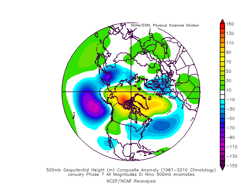
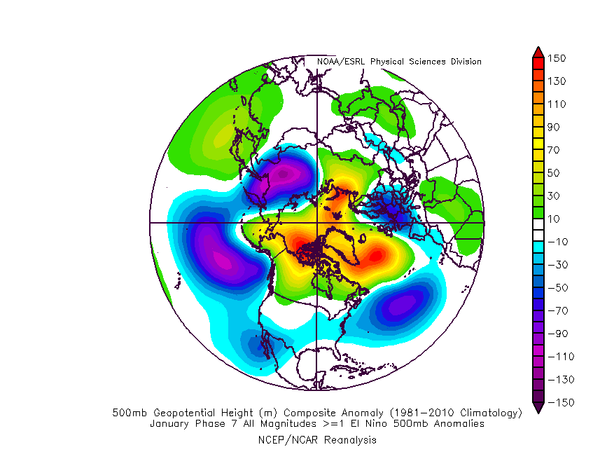


That's for low amplitude phase 7 on the left and high amplitude on the right.


It looks phenomenal for us BUT it's based on theory that as far as I know requires the Pacific SST pattern to match a typical El Nino pattern when actually we have had an unusual amount of warmth remaining in the western Pacific and interfering with things.


So the response may not be entirely in line with the above... assuming the MJO reaches phase 7 in the first place!


If you have any problems or queries relating to TWO you can Email [email protected]

https://twitter.com/peacockreports 
2023's Homeland Extremes:
T-Max: 30.2°C 9th Sep (...!) | T-Min: -7.1°C 22nd & 23rd Jan | Wettest Day: 25.9mm 2nd Nov | Ice Days: 1 (2nd Dec -1.3°C in freezing fog)
Keep Calm and Forecast On
tallyho_83
03 January 2015 11:47:36


Definitely a change to colder weather on the way from Mid-month but will this hold and can these could GFS runs stay persistent and continue with the cold theme - even into FI!?


Home Location - Kellands Lane, Okehampton, Devon (200m ASL)
---------------------------------------
Sean Moon
Magical Moon
www.magical-moon.com


Solar Cycles
03 January 2015 11:57:51

IMO around mid month onwards we'll see a pattern similar to what we experienced during the latter half of December with a displaced Azores  High and a trough over Scandi leaving the UK in a cool NW airflow, so all in all the rain will  just be colder down South whilst elevated Northern areas will see more  in the way of wintry precipitation. I just can't see a pattern change to deep cold anytime soon with SSW events having little impact for our neck of the woods.

nsrobins
03 January 2015 12:16:37

Some posters falling into the trap of putting specifics on things 15 days out which is a recipe for disappointment.
Just take the general theme and median clusters and not single runs in isolation and accept that there is a small chance of colder synoptics for now would be my advice.


By the way, for eye-popping fun have a look at member 11 in the GFS suite. What is going on there LOL?


And for cluster analysis:
http://www.meteociel.fr/cartes_obs/gens_display.php?ext=1&x=306&y=141&ville=Londres


As strong a signal for 850s to head south later on as there's been so far.


Neil
Fareham, Hampshire 28m ASL (near estuary)
Stormchaser, Member TORRO
doctormog
03 January 2015 12:32:06


Some posters falling into the trap of putting specifics on things 15 days out which is a recipe for disappointment.
Just take the general theme and median clusters and not single runs in isolation and accept that there is a small chance of colder synoptics for now would be my advice.


By the way, for eye-popping fun have a look at member 11 in the GFS suite. What is going on there LOL?


And for cluster analysis:
http://www.meteociel.fr/cartes_obs/gens_display.php?ext=1&x=306&y=141&ville=Londres


As strong a signal for 850s to head south later on as there's been so far.


Originally Posted by: nsrobins 


I would agree with all that Neil however I would tend to use the word increasing where you have used small.


SEMerc
03 January 2015 12:34:47


Latest CFS V2 charts are showing tentative signs of heights building around Greenland............... In July.


Originally Posted by: Solar Cycles 


Gooner
03 January 2015 13:00:41


I would agree with all that Neil however I would tend to use the word increasing where you have used small.


Originally Posted by: doctormog 


I would also add , that IMO people aren't taking these far out charts seriously , surely they aren't. But they are worth posting all the same just for trend purposes .


If they are still there Monday afternoon then the trend could become reality


JFF all of course


Remember anything after T120 is really Just For Fun


Marcus
Banbury
North Oxfordshire
378 feet A S L


Retron
03 January 2015 13:00:46


I would agree with all that Neil however I would tend to use the word increasing where you have used small.


Originally Posted by: doctormog 


Yes, it's not a small chance IMO - and it's increasing.


I regard the ensembles as being the best thing we have when it comes to checking for pending changes in pattern type and the last few runs from both ECM and GEFS have shown the same thing - a trend towards colder conditions for the latter half of the month.


It reminds me very much of the last cold spell. ECM picked up on that right at the edge of its range and over the following two weeks more and more runs fell into the cold cluster. In the end it firmed up on around a week's worth of cold weather - which, down here at least, is exactly what we ended up with (with the exception of the overnight period of the 26th-27th, in which temperatures went above 6C for four hours).


Leysdown, north Kent
picturesareme
03 January 2015 13:23:29


I would also add , that IMO people aren't taking these far out charts seriously , surely they aren't. But they are worth posting all the same just for trend purposes .


If they are still there Monday afternoon then the trend could become reality


JFF all of course


Originally Posted by: Gooner 


are you kidding? Lol, Tallyho does, have never scrolled through his/ her posts. 

Gooner
03 January 2015 13:30:07


are you kidding? Lol, Tallyho does, have never scrolled through his/ her posts. 


Originally Posted by: picturesareme 


Tally doesn't count , he only does it to wind everyone up


Remember anything after T120 is really Just For Fun


Marcus
Banbury
North Oxfordshire
378 feet A S L


picturesareme
03 January 2015 13:38:40


Tally doesn't count , he only does it to wind everyone up


Originally Posted by: Gooner 


wind up yes, lol. 😄 But I thought he was genuine.

Gusty
03 January 2015 13:53:00

This week I will mostly be watching the ensembles.


No chart available for the selected hour. Many charts start at 3 hours ahead, so if you have 0 hours selected try stepping forward or selecting a later hour.


Hopefully the trend will continue and that by next Saturday we can start looking at some specifics. 


Steve - Folkestone, Kent
Current conditions from my Davis Vantage Vue
https://www.wunderground.com/dashboard/pws/IFOLKE11 
Join Kent Weather on Facebook.
https://www.facebook.com/stevewall69/ 


Hungry Tiger
03 January 2015 14:25:32


Definitely a change to colder weather on the way from Mid-month but will this hold and can these could GFS runs stay persistent and continue with the cold theme - even into FI!?


Originally Posted by: tallyho_83 


If that was to come off my goodness. Heavy snow definitely.


Gavin S. FRmetS.
TWO Moderator.
Contact the TWO team - [email protected]
South Cambridgeshire. 93 metres or 302.25 feet ASL.


The Beast from the East
03 January 2015 14:30:42

Most of the GEFS are good at long range. Clearly a strong background signal being picked up for a split vortex and atlantic ridging north


"We have some alternative facts for you"
Kelly-Ann Conway - special adviser to the President
hammer10
03 January 2015 14:32:03
Looks a bit like 2010 dec 18th
Rob K
03 January 2015 14:51:37
Hmm. I haven't looked at the models much lately as they seemed to be stuck in a rut, but both GFS and PGFS this morning look quite interesting towards the third week of Jan.

I've just had 45 cubic feet of logs delivered, by coincidence 🙂
Yateley, NE Hampshire, 73m asl
"But who wants to be foretold the weather? It is bad enough when it comes, without our having the misery of knowing about it beforehand." — Jerome K. Jerome

Remove ads from site

Ads