Remove ads from site

Solar Cycles
03 January 2015 14:52:42


Most of the GEFS are good at long range. Clearly a strong background signal being picked up for a split vortex and atlantic ridging north


Originally Posted by: The Beast from the East 

the trouble is any split in the Strat is only a temporary feature and thereafter it's expected to reform leaving a segment over its favourite cold busting home of Greenland.

03 January 2015 15:05:38

Yesterday I thought about posting about the fact that what we were missing this year was any genuinely interesting runs showing proper winter synoptics even in distant FI. Seems like the GFS over the last 24 hours read my thoughts and decided to do something about that. Very nice eye candy ( and that is all it is at the moment).

If ECM starts to bring similar charts inside 180, I may raise an eyebrow slightly more. ( in a Roger Moore kind of way)

and if something remotely related to what those charts are showing turns up on the Meto 6-15 text then I may have to rub my chin and go hmmmmmmmm
that looks interesting.

It is goodfor us coldies to see some nice winter synoptics showing up but remember the mantra.

''You can scream and shout your happinness about ECM AND GFS
but it simply will not happen until the UKMET say yes.''

Quantum
03 January 2015 16:14:46


the trouble is any split in the Strat is only a temporary feature and thereafter it's expected to reform leaving a segment over its favourite cold busting home of Greenland.


Originally Posted by: Solar Cycles 


It doesn't matter SC, we don't live in the strat. Easterly winds in the strat merely stop the propagation of westerly winds upwards and result instead of the propagation of easterlies down, and its going to take a couple of weeks for those easterlies to get to the trop, and it is the trop disruption that is important to us. 


2023/2024 Snow days (approx 850hpa temp):
29/11 (-6), 30/11 (-6), 02/12 (-5), 03/12 (-5), 04/12 (-3), 16/01 (-3), 18/01 (-8), 08/02 (-5)

Total: 8 days with snow/sleet falling.

2022/2023 Snow days (approx 850hpa temp):

18/12 (-1), 06/03 (-6), 08/03 (-8), 09/03 (-6), 10/03 (-8), 11/03 (-5), 14/03 (-6)

Total: 7 days with snow/sleet falling.

2021/2022 Snow days (approx 850hpa temp):

26/11 (-5), 27/11 (-7), 28/11 (-6), 02/12 (-6), 06/01 (-5), 07/01 (-6), 06/02 (-5), 19/02 (-5), 24/02 (-7), 30/03 (-7), 31/03 (-8), 01/04 (-8)
Total: 12 days with snow/sleet falling.
Solar Cycles
03 January 2015 16:50:48


It doesn't matter SC, we don't live in the strat. Easterly winds in the strat merely stop the propagation of westerly winds upwards and result instead of the propagation of easterlies down, and its going to take a couple of weeks for those easterlies to get to the trop, and it is the trop disruption that is important to us. 


Originally Posted by: Quantum 

It won't matter as the PV will be reforming in week 3. We need more wave 2 activity to completely destroy the PV.

nsrobins
03 January 2015 17:01:42

I'll meet you the 06Z GFSP and raise you the 12Z GFSP


All FI and fun but that's another run with tasty looking synoptics from Day 12/13. Tick tock and all that.


Neil
Fareham, Hampshire 28m ASL (near estuary)
Stormchaser, Member TORRO
Twister
03 January 2015 17:06:13

GFS 12Z: The far reaches of FI maintain the trend from zonality to a meridional pattern favouring blocking to our W and NW and a northerly airflow. The Para also suggests this trend.


Next weekend could see wintry showers for some, especially northern areas, as a colder wave of zonality sweeps across the UK. For example:


http://modeles2.meteociel.fr/modeles_gfs/runs/2015010312/174-574PUK.GIF?03-12


Location: Egerton, Kent - 33m ASL
Thunder 2016: 12 (Apr 3,13; May 21; Jun 8,11,17,22,23,25, Jul 2,12, Aug 26)
Winter 2015/6: Snowfalls: 10 | Snowcover: 2 (Jan 17 (0.5cm)) | Air frosts: 39
Winter 2016/7: Snowfalls: 4 (Jan 12-3, Feb 10-11) | Snowcover: 2 (Jan 13, 2cm, Feb 11, 3-5mm) | Air frosts: 57 (2 in Oct, 10 in Nov, 13 in Dec, 19 in Jan, 6 in Feb, 3 in Mar, 4 in Apr)
"The heavens tell of the glory of God. The skies display his marvellous craftsmanship." (Psalm 19:1)
Solar Cycles
03 January 2015 17:10:16
It's still over 10 days away but all I see is something similar to last month, a 3-5 day cold snap possibly before the jet topples the high back to the Azores. Still it gives us all some eye candy.
nsrobins
03 January 2015 17:17:44

It's still over 10 days away but all I see is something similar to last month, a 3-5 day cold snap possibly before the jet topples the high back to the Azores. Still it gives us all some eye candy.

Originally Posted by: Solar Cycles 


Only the CFS goes that far SC. This is the model discussion thread, so if you could reference your prediction with links that show this I'd be grateful.
Or perhaps you are basing your forecast on other factors currently not shown on an output?


Neil
Fareham, Hampshire 28m ASL (near estuary)
Stormchaser, Member TORRO
Gooner
03 January 2015 17:18:48

It's still over 10 days away but all I see is something similar to last month, a 3-5 day cold snap possibly before the jet topples the high back to the Azores. Still it gives us all some eye candy.

Originally Posted by: Solar Cycles 


I don't, the 6z ENS certainly show the most support for a cold spell so far .


http://www.theweatheroutlook.com/charts/gefs/gefsens850london0.png?cb=815  6z ens


Remember anything after T120 is really Just For Fun


Marcus
Banbury
North Oxfordshire
378 feet A S L


Quantum
03 January 2015 17:23:26

The 12Z GFSP is not without support, the ensembles have been trending in this direction for days, also with the control AND the OP both towards the cold end, there is perhaps a suggesion they could continue to trend colder. Anyway the period of the trop disrpution is becoming increasingly visible. 


2023/2024 Snow days (approx 850hpa temp):
29/11 (-6), 30/11 (-6), 02/12 (-5), 03/12 (-5), 04/12 (-3), 16/01 (-3), 18/01 (-8), 08/02 (-5)

Total: 8 days with snow/sleet falling.

2022/2023 Snow days (approx 850hpa temp):

18/12 (-1), 06/03 (-6), 08/03 (-8), 09/03 (-6), 10/03 (-8), 11/03 (-5), 14/03 (-6)

Total: 7 days with snow/sleet falling.

2021/2022 Snow days (approx 850hpa temp):

26/11 (-5), 27/11 (-7), 28/11 (-6), 02/12 (-6), 06/01 (-5), 07/01 (-6), 06/02 (-5), 19/02 (-5), 24/02 (-7), 30/03 (-7), 31/03 (-8), 01/04 (-8)
Total: 12 days with snow/sleet falling.
The Beast from the East
03 January 2015 17:24:20

Another good set of GFS FI runs. Lets hope its not one of those mirages and always stays at  T+300 


"We have some alternative facts for you"
Kelly-Ann Conway - special adviser to the President
ITSY
03 January 2015 17:27:22

interesting also that GFSp in particular takes us down another atlantic route to cold. Not yet a question of all runs lead the same direction, but good to see that even with that initial monster low out of Canada, the ridge manages to discover a way North. Trends for now...

The Beast from the East
03 January 2015 17:31:56

We mustnt forget the potential for severe wind events as the trough sinks south


http://modeles.meteociel.fr/modeles/gens/runs/2015010312/gensnh-2-1-216.png


"We have some alternative facts for you"
Kelly-Ann Conway - special adviser to the President
Solar Cycles
03 January 2015 17:33:27


Only the CFS goes that far SC. This is the model discussion thread, so if you could reference your prediction with links that show this I'd be grateful.
Or perhaps you are basing your forecast on other factors currently not shown on an output?


Originally Posted by: nsrobins 

the jet is running over the top of the high and it would only be a matter of time before the whole lot topples, we need to see stronger riidging into Greenland without this we'll be looking at something similar to last month, though the South may do better this time around.

Gooner
03 January 2015 17:38:38


the jet is running over the top of the high and it would only be a matter of time before the whole lot topples, we need to see stronger riidging into Greenland without this we'll be looking at something similar to last month, though the South may do better this time around.


Originally Posted by: Solar Cycles 


http://modeles.meteociel.fr/modeles/gfsp/runs/2015010312/gfsnh-0-384.png?12


You mean like this as per GFSP , nice greens and yellows into Greenland


Remember anything after T120 is really Just For Fun


Marcus
Banbury
North Oxfordshire
378 feet A S L


The Beast from the East
03 January 2015 17:38:58

Control ok as well


http://modeles.meteociel.fr/modeles/gens/runs/2015010312/gensnh-0-1-288.png


"We have some alternative facts for you"
Kelly-Ann Conway - special adviser to the President
David M Porter
03 January 2015 17:39:16


the jet is running over the top of the high and it would only be a matter of time before the whole lot topples, we need to see stronger riidging into Greenland without this we'll be looking at something similar to last month, though the South may do better this time around.


Originally Posted by: Solar Cycles 


What the GFS is showing in FI at the moment would at least be a start of us moving out of the current pattern. Whether or not it then turns into something more significant for cold, we have no idea of just now- it's way too far ahead to have any idea right now. The jet may well run over the top again and push the HP back south, it may not. We have a long way to go right now before we even get to what GFS FI is suggesting right now, if that verifies of course. Whatever comes along after that can only be wild speculation just now.


Lenzie, Glasgow

"Let us not take ourselves too seriously. None of us has a monopoly on wisdom, and we must always be ready to listen and respect other points of view."- Queen Elizabeth II 1926-2022
The Beast from the East
03 January 2015 17:42:04

For once severe cold across the NE USA does not ruin our chances


http://modeles.meteociel.fr/modeles/gens/runs/2015010312/gensnh-0-0-312.png


"We have some alternative facts for you"
Kelly-Ann Conway - special adviser to the President
Quantum
03 January 2015 17:43:33


For once severe cold across the NE USA does not ruin our chances


http://modeles.meteociel.fr/modeles/gens/runs/2015010312/gensnh-0-0-312.png


Originally Posted by: The Beast from the East 


It because we have a rare but classical west based -NAO setup, they are essentially the holy grail of cold setups and cold for both sides of the atlantic but warm for most of canada. 


2023/2024 Snow days (approx 850hpa temp):
29/11 (-6), 30/11 (-6), 02/12 (-5), 03/12 (-5), 04/12 (-3), 16/01 (-3), 18/01 (-8), 08/02 (-5)

Total: 8 days with snow/sleet falling.

2022/2023 Snow days (approx 850hpa temp):

18/12 (-1), 06/03 (-6), 08/03 (-8), 09/03 (-6), 10/03 (-8), 11/03 (-5), 14/03 (-6)

Total: 7 days with snow/sleet falling.

2021/2022 Snow days (approx 850hpa temp):

26/11 (-5), 27/11 (-7), 28/11 (-6), 02/12 (-6), 06/01 (-5), 07/01 (-6), 06/02 (-5), 19/02 (-5), 24/02 (-7), 30/03 (-7), 31/03 (-8), 01/04 (-8)
Total: 12 days with snow/sleet falling.
Stormchaser
03 January 2015 17:50:53

There is very good run-to-run and even cross-model consistency with the build of heights poleward from Siberia days 6-10, which suggests an unusually strong signal for it to behave in that way.


During that time, the MJO is projected by GEFS to reach phase 6 while in an amplified state, and the composite for that fits the 6-10 day trop. output very closely indeed (GFS day 8 used as an example on the right, GFSP is very similar):
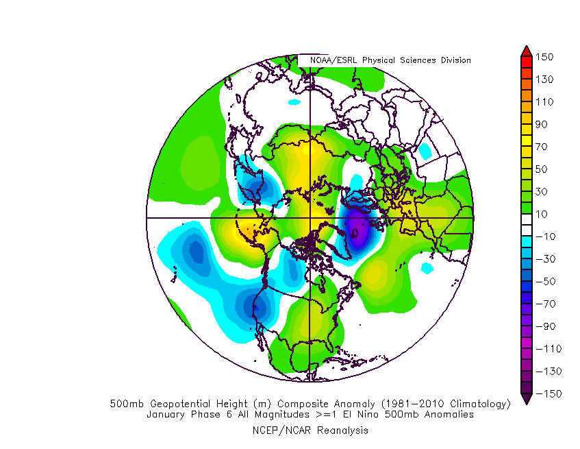

  No chart available for the selected hour. Many charts start at 3 hours ahead, so if you have 0 hours selected try stepping forward or selecting a later hour.


Unfortunately the MJO outlook charts aren't working properly this evening so I can't be sure what the latest from the models is.


With ECM also bearing close resemblance in the 6-10 day range lately, I can only guess that it is modelling a similar MJO progression.


This then brings us to a critical point, right on the edge of ECM/GFSP higher-res, when the ridge from Siberia reaches a location from which it can force a tropospheric polar vortex split:


No chart available for the selected hour. Many charts start at 3 hours ahead, so if you have 0 hours selected try stepping forward or selecting a later hour.  No chart available for the selected hour. Many charts start at 3 hours ahead, so if you have 0 hours selected try stepping forward or selecting a later hour.


(For now I have GFSP on the left and GFS on the right, I intend to swap in the ECM chart later this evening).


This is when the MJO phase 7 forcing seems to make itself known in the output, as we see a very 'forced' appearance to the runs days 11-16, where height rises to the west and northwest just keep on coming regardless of various low pressure systems trying to trash the party.


I'm pretty sure that this isn't strat.-forced, because the current 30hPa split doesn't appear at lower levels just before this takes place. Instead we are seeing a split driven from the troposphere.


It's apparent dependence on the MJO means we need to give this a good number of days before we can start to consider it a likely outcome. The ECM ensembles were not keen on taking it through phase 7 when I last saw the MJO output two days ago, but this may well have changed considering the way this morning's ECM control run unfolded. They did underestimate the progression back in December and perhaps this is happening again.


Perhaps.


In light of Solar Cycle's posts, I would like to add that the vortex looks like being quite a lot weaker for week 3 of January than it was when we went through the sequence last month, so I think any cold setup would last a little longer this time around.


If we could see further wave 2 activity during this time, that would start to bring a longer lasting cold spell into the realms of possibility. So far there are hints of it in some model runs but it's not very enthusiastic.


I'll be keeping my expectations down to a few days of cold, snowy conditions at most until if and when better wave breaking develops in the output.


If you have any problems or queries relating to TWO you can Email [email protected]

https://twitter.com/peacockreports 
2023's Homeland Extremes:
T-Max: 30.2°C 9th Sep (...!) | T-Min: -7.1°C 22nd & 23rd Jan | Wettest Day: 25.9mm 2nd Nov | Ice Days: 1 (2nd Dec -1.3°C in freezing fog)
Keep Calm and Forecast On
Quantum
03 January 2015 17:57:52

Esembles are difficulty picking something up here, in the last week we have gone from 100% zonal right out to 384hr to this, I think this is related to the strat warming.


Anyway at 336hr


Greenland block (established or in transition): ||


Total: 2


Mid-atlantic high, polar maritime: ||||||


Total: 6


Mid-atlantic high, arctic toppler: ||


Total: 2


Mid-atlantic high, stable arctic: ||||


Total: 4


Icelandic vortex (zonal): ||||


Total: 4


Euro/Southern/Bartlett: |||


Total 3:


Hope index = 2+6+2+4/2+6+2+4+4+3 = 67%


Contrived pattern (consider ignoring): | *This pattern is also ambiguous so would be neutral on the hope index anyway


Before the new year a few days after xmas the hope index was always 0% with virtually 100% icelandic vortex showing up right to 384. Now we have 2/3 good pattern by the 17th. 


2023/2024 Snow days (approx 850hpa temp):
29/11 (-6), 30/11 (-6), 02/12 (-5), 03/12 (-5), 04/12 (-3), 16/01 (-3), 18/01 (-8), 08/02 (-5)

Total: 8 days with snow/sleet falling.

2022/2023 Snow days (approx 850hpa temp):

18/12 (-1), 06/03 (-6), 08/03 (-8), 09/03 (-6), 10/03 (-8), 11/03 (-5), 14/03 (-6)

Total: 7 days with snow/sleet falling.

2021/2022 Snow days (approx 850hpa temp):

26/11 (-5), 27/11 (-7), 28/11 (-6), 02/12 (-6), 06/01 (-5), 07/01 (-6), 06/02 (-5), 19/02 (-5), 24/02 (-7), 30/03 (-7), 31/03 (-8), 01/04 (-8)
Total: 12 days with snow/sleet falling.
Gooner
03 January 2015 18:00:28


dream on LOL


Something is rumbling in FI, but I won't raise an eyebrow until it's into the reliable timeframe. more jam tomorrow for coldies, but worth keeping an eye on the ENS if indeed it's cold weather your after. 


Originally Posted by: JACKO4EVER 


There isn't much to shout about if your looking for dry mild weather either matey


Remember anything after T120 is really Just For Fun


Marcus
Banbury
North Oxfordshire
378 feet A S L


Gooner
03 January 2015 18:03:49


My age is probably one of the most interesting things to discuss at the moment 


Hope of EPS being slightly better is dashed. This is a returning polar airmass, which means while it might be below avg in the NW, it is mundane for the rest of us, and probably quite wet. Same show as last year really. All I can hope is that we get some ice forming down the E coast soon to slow the cyclogenesis. Didn't work last year ofc and there was plenty of ice then.


Originally Posted by: Quantum 


And this is what you posted 5 days ago Q


How your view has changed eh?


Remember anything after T120 is really Just For Fun


Marcus
Banbury
North Oxfordshire
378 feet A S L


Remove ads from site

Ads