Remove ads from site

The Beast from the East
06 January 2015 17:23:25

GFS parrallel again wants to destroy the UK. Perhaps we should rename it the Daily Express model


http://modeles.meteociel.fr/modeles/gfsp/runs/2015010612/gfs-0-204.png?12


"We have some alternative facts for you"
Kelly-Ann Conway - special adviser to the President
eastcoaster
06 January 2015 17:29:07


GFS parrallel again wants to destroy the UK. Perhaps we should rename it the Daily Express model


http://modeles.meteociel.fr/modeles/gfsp/runs/2015010612/gfs-0-204.png?12


Originally Posted by: The Beast from the East 

It is amazing and it's not just the GFSP, all the models have at times completely over egged the LPs hitting the UK. In fact the winter here at least hasn't even been overly stormy, just a very typical boring British winter. 

Snow Hoper
06 January 2015 17:41:44

Thanks for the comparisons Darren, I can see exactly what you're getting at.


Going to war over religion is like killing each other to see who has the better imaginary friend.


Home : Thorndon, Suffolk.
LA2B MeridFlowEuro09
06 January 2015 17:58:46

Alright then.


Now GFS 12z run from 168- 216 does bring further Deep and Cold Low Pressure but will it bring rain or sleet or will it be cold enough for snow even in South and SE UK, I'd wait for the 15-16 January Wish dreamt up more RUNS needed ahem.


The SE Digging NW Atlantic Low with Big High over E Canada and main PV focused at NE Atlantic plus N Atlantic, Need the Greenland High spread wings hooray, and by next Week Wednesday evening look our West esp. SW - Tuesday 13th shows NW airflow and chance of widespread night frost for much of UK, 14-15th maybe in dreamland rain WITH Sleet and Snow Hills can come West SW wind then NW flow with it well GFS FI has telling us, hope the next few days FI UKMO 96-120 and 144 show those dates offer winter wonderland weather that they might model to OCCUR.


North Atlantic PV Low West to East this week, this Weekend and on Monday to early Tuesday with Trofs, Lows and Parent Low focused to its NW N and NE and that also implies the UK get so we'll be seeing Short waves okay then.


Lot of Cold Air to our nearsides NW North and NE, but we getting cool cold and also some mild weather, the UKMO and GFS show that okay then.


Climate is warming up, Scotland and N Ireland and North England still often gets some Winter frost, ice and snow, November to March, but the SE and South UK including S Central England and Wales, together with the West and North through the year, they sometimes get more rain than London and S SE England, where some longer dry fine spells without much heavy rain is seen every year.

The North Atlantic Sea often gets some much Colder Wintry conditions from November to March Months, and Mild SW and South winds tend to be more frequent over the East and SE of North Atlantic Sea, as the Azores High tends to stay in charge. 

With this warmth and heat, the Central and South UK has become mostly free of snow and frost.
llamedos
06 January 2015 18:00:15


Thanks for the comparisons Darren, I can see exactly what you're getting at.


Originally Posted by: Snow Hoper 

Indeed..........a perfect and easy to follow example of the folly of cherry picking rather than looking at the bigger picture


"Life with the Lions"

TWO Moderator
Stormchaser
06 January 2015 18:01:57

Yeah, quit it GFSP... that storm would be devastating if it verified with near 90mph gusts across the central swathe of the UK following 100mph gusts across Ireland.


It happens to coincide with the final moments of the very strong jet that we look to have firing at us for much of the next 9 days


The jet then weakens dramatically and a mid-Atlantic ridge builds. This is the key opportunity for a colder spell to establish, with plenty of scope for the ridge to build up towards the higher latitudes as the polar vortex is in a very disorganised state.


However... enough amplification is needed across the U.S. to achieve this, so that the seemingly inevitable low pressure development along the cold/mild boundary (where the subtropical jet is) is forced to behave in favour of sustaining or building the ridge rather than flattening it.


GFSP is not far away days 9-10 but it's not quite enough... the jet is then boosted again and we see a strong trough push from NW of the UK to NE.


Massive high latitude blocking then springs up from the Pacific, probably due to the MJO hanging around in a favourable location (phase 6/7) combined with the strat. vortex wandering away from Greenland toward Scandinavia, but that's a whole other kettle of fish.


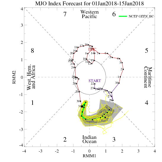
Speaking of the MJO, the EC-32 (see below left) has that decaying in phase 7 (favours increased high latitude blocking but happens too fast for much of a pattern response to occur), then redeveloping just a few days later in phase 6 (good for strong pole-ward ridges of high pressure), back on route to phase 7. That would lead to a lot of amplification of the pattern by the end of this month if it verified, which explains the news from Ferguson.
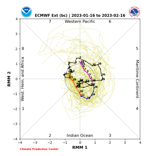


As for the bias-corrected GEFS (above right), they show a stronger MJO in the next 5-6 days followed by something briefly closer to ECM, after which they really diverge as there is no decay on the GEFS(BC) output.


While the Met Office consider GEFS to be overdoing it, these bias corrected runs actually make the MJO even stronger, though with less progression east toward phase 8.


There are some highly technical reasons to believe that the MJO will make it further east without decay than has been the case for a long time, which I am still trying to get my head around, but seems to boil down to the decline at the turn of the year of an atmospheric setup that had for a long time been 'enticing' the MJO to keep returning to the Indian Ocean/Maritime Continent rather than set up shop in the Pacific, rooting it in locations unfavourable for driving amplification of the hemispheric pattern.


The Indian Ocean in particular is now looking hostile to the MJO so it looks like travelling to the Pacific during the coming week, after which warm SST anomalies associated with the on going El Nino pattern (though weak) may help to keep it there rather than letting it travel on towards the western hemisphere and Africa.


ECM decayed the MJO a bit too quickly back in December (period of 7th-14th, visible as red line on each chart - ECM at about a week's range had it totally decayed before even reaching phase 7) so I believe some adjustment toward GEFS(BC) may occur. Equally, the GEFS(BC) may tone it down a bit... a typical coming together of the output.


If you have any problems or queries relating to TWO you can Email [email protected]

https://twitter.com/peacockreports 
2023's Homeland Extremes:
T-Max: 30.2°C 9th Sep (...!) | T-Min: -7.1°C 22nd & 23rd Jan | Wettest Day: 25.9mm 2nd Nov | Ice Days: 1 (2nd Dec -1.3°C in freezing fog)
Keep Calm and Forecast On
bledur
06 January 2015 18:35:57

Once again looking cooler , but not real cold


 Slideshow image

Rob K
06 January 2015 18:41:16


GFS parrallel again wants to destroy the UK. Perhaps we should rename it the Daily Express model


http://modeles.meteociel.fr/modeles/gfsp/runs/2015010612/gfs-0-204.png?12


Originally Posted by: The Beast from the East 


Not quite as bonkers as the low it came up with a couple of runs ago. 915mb LOL


Yateley, NE Hampshire, 73m asl
"But who wants to be foretold the weather? It is bad enough when it comes, without our having the misery of knowing about it beforehand." — Jerome K. Jerome
Scandy 1050 MB
06 January 2015 18:47:03


Once again looking cooler , but not real cold


 Slideshow image


Originally Posted by: bledur 


Both GFS models seem to be stuck in panto mode at the moment...oh yes it will...oh no it won't!  Such wild swings I would suggest their reliability beyond this weekend is questionable if not before let alone that far ahead. All JFF of course, but even in Gavin's excellent update video today the whole of the Stratosphere looks vastly different since he did the video with suggestions now of the warming moving to North of Scandinavia albeit not as warm:


http://www.meteociel.fr/modeles/gfse_cartes.php?&ech=144&mode=10&carte=1


It's also changed in the lower atmosphere too.


I think we really need to wait until it comes into the GEM / ECM time frame to get a better idea of what's really going to occur. As others have noticed both GFS models want to develop ferocious Low Pressure systems to steam into the middle of the UK - hopefully the models are wrong on that one.   Great posts from everyone especially Stormchaser and Darren with the ensembles post, interesting model watching currently as it's changing quite a lot on each run.


nsrobins
06 January 2015 18:56:52


EPS, maybe (although in reality it's just a shift from the majority of runs in the cold cluster to a roughly equal split) but GEFS - no way.


So that everyone can see why I'm saying this, on top is today's 6z output. And below, the 6z output from 3 days ago. It is not a downgrade - indeed, it shows remarkable consistency.


The problem is that people get too hung up on the operational run, or individual members, or even the exact point of the mean, rather than looking at the suite and overall pattern as a whole.


Originally Posted by: Retron 


That is actually a very useful way to show how the suite should be taken as a community and not as individual runs and you are right, we do tend to focus on the OP runs as they are a higher resolution but I concur I was wrong with my assessment.

I hope the GFSP has got that monster low wrong next week as the consequences could be quite serious.


Neil
Fareham, Hampshire 28m ASL (near estuary)
Stormchaser, Member TORRO
Whether Idle
06 January 2015 19:18:25


Well, I'll point out that the models have never been showing what Brian's definition of a cold spell is - so the signal can't be waning!


The signal (which still remains) is for a decent chance of a colder-than-average spell. Nothing has changed in that regard either.


Originally Posted by: Retron 


What is Brian's definition of a colder spell?


Dover, 5m asl. Half a mile from the south coast.
Stormchaser
06 January 2015 19:34:57

ECM still puts up a fight to keep the trough further north with a flatter jet, but the amplification finally shows its hand on day 10 of the 12z op run. Still lacking in U.S. amplification,but less aggressive with the subtropical jet and LP development along it so still some room for the mid-Atlantic ridge to establish as the jet dives south through the UK - would probably end up being a mid-latitude block across the UK though, chilly but lacking in snow.


It's funny how this has been the most reluctant operational output to amplify things in the 7-10 day range lately. Almost as if it caught wind of the idea that it was biased toward Amplification at that range and decided to contradict the notion as strongly as it could


Of course the truth lies with the MJO projections, as detailed earlier this evening.


Increasingly I am being given the impression that we are odds on for the pattern to become increasingly favourable for cold weather patterns to affect UK from mid January right on through February, making it a race against time to get something decent across more southern parts before the increasing solar input starts to drastically reduce the potential. Further north can rest easier I feel.


This impression comes from more than the MJO; it's not uncommon to see a turn away from zonality during February and March -even last winter we saw that happen to some extent - and in winters with a weak El Nino such as we have at the moment, this transition tends to happen sooner, based on analogue composites.


It could be that "too little, too late?" becomes the million dollar question by the third week of this month.


If you have any problems or queries relating to TWO you can Email [email protected]

https://twitter.com/peacockreports 
2023's Homeland Extremes:
T-Max: 30.2°C 9th Sep (...!) | T-Min: -7.1°C 22nd & 23rd Jan | Wettest Day: 25.9mm 2nd Nov | Ice Days: 1 (2nd Dec -1.3°C in freezing fog)
Keep Calm and Forecast On
sizzle
06 January 2015 19:35:16


What is Brian's definition of a colder spell?


Originally Posted by: Whether Idle 

A Bartlett

Hippydave
06 January 2015 21:30:50

Must admit I quite liked the 12z GFS ens set - a few colder runs near the end, mainly courtesy of a HP establishing over Scandi. Before that the cooler/coldish 'spell/snap' is still shown, which is pretty good consistency wise if nothing else


The follow on Scandi HP route is very much in the minority but probably the most plausible route to a more prolonged colder solution at present. 


There are of course rather more in the way of milder runs but even here a reasonable number are HP over or near the UK, which would probably not be all that warm at the surface.


All too far out for more than interest value but still overall a continuation of the trend to a cooler set up, once the immediate unsettled and potentially stormy period runs out. Thereafter who knows what'll happen - it's not looking flat zonal but ofc more than enough time for that to change.


Who knows perhaps amplified and cooler will be the pattern that sets in for weeks and weeks and weeks rather like the current zonal blip was declared to be


Home: Tunbridge Wells
Work: Tonbridge
Sevendust
06 January 2015 21:54:43

From a purely weather POV the most interesting thing is the projected storm at the weekend. Sub 940mb on the fax and likely to give the north a battering

festivalking
06 January 2015 22:08:38


It could be that "too little, too late?" becomes the million dollar question by the third week of this month.


[/quote


]


Just to take on the theme. Not sure anyone can claim that by March you can't get  lying snow south of Birmingham as the residents of the channel islands can testify after they were buried in March 2013.


Still all to play for being that it's the start of January. But admittedly it's rather trying.


Dousland, Dartmoor 206 m/asl
Its only going to snow when Gibby says so.
Brian Gaze
06 January 2015 22:24:49

Here we go again with the GFSP18z!


http://www.theweatheroutlook.com/twodata/datmdlout.aspx


Brian Gaze
Berkhamsted
TWO Buzz - get the latest news and views 
"I'm not socialist, I know that. I don't believe in sharing my money." - Gary Numan
Fothergill
06 January 2015 22:38:19

Looks like the pub run has been hitting the sauce again.


doctormog
06 January 2015 22:39:13
http://www.wetterzentrale.de/pics/Rtavn2881.html 

Nice to look at but at that range it is little more than entertainment value. I guess it shows one of the possibilities.
idj20
06 January 2015 22:46:10

Has Madden & co hacked into GFSP's mainframe? If that thing at 198 hrs on the 18z output actually came off, that would be worse than St Burns Day storm of 25th Jan '90. http://modeles.meteociel.fr/modeles/gfsp/runs/2015010618/gfs-0-198.png?18
 
Whereas the old skool GFS shows a much toned down version, but all the other models aren't even showing anything of the sort (which I'm sure will get picked up on in the next run).


Folkestone Harbour. 
Sevendust
06 January 2015 22:47:54


Here we go again with the GFSP18z!


http://www.theweatheroutlook.com/twodata/datmdlout.aspx


Originally Posted by: Brian Gaze 

Sting jet

Quantum
06 January 2015 22:49:43


Has Madden & co hacked into GFSP's mainframe? If that thing at 198 hrs on the 18z output actually came off, that would be worse than St Burns Day storm of 25th Jan '90. http://modeles.meteociel.fr/modeles/gfsp/runs/2015010618/gfs-0-198.png?18
 
Whereas the old skool GFS shows a much toned down version, but all the other models aren't even showing anything of the sort (which I'm sure will get picked up on in the next run).


Originally Posted by: idj20 


There are certain 'contrived' patterns I ignore on any/all models. I'm not sure if this is correct, but when a monster storm is predicted on the NWP models it will almost certainly be over exaggerated, in fact I think its fairly common to see 'record breaking' storms in the output, they tend to get moderated. I'd be more worried about the storms that are making it into the reliable timeframe, they really could be severe, though storm force winds in the far north of Scotland isn't that unusual, and being from the west it won't do that much damage. 


2023/2024 Snow days (approx 850hpa temp):
29/11 (-6), 30/11 (-6), 02/12 (-5), 03/12 (-5), 04/12 (-3), 16/01 (-3), 18/01 (-8), 08/02 (-5)

Total: 8 days with snow/sleet falling.

2022/2023 Snow days (approx 850hpa temp):

18/12 (-1), 06/03 (-6), 08/03 (-8), 09/03 (-6), 10/03 (-8), 11/03 (-5), 14/03 (-6)

Total: 7 days with snow/sleet falling.

2021/2022 Snow days (approx 850hpa temp):

26/11 (-5), 27/11 (-7), 28/11 (-6), 02/12 (-6), 06/01 (-5), 07/01 (-6), 06/02 (-5), 19/02 (-5), 24/02 (-7), 30/03 (-7), 31/03 (-8), 01/04 (-8)
Total: 12 days with snow/sleet falling.
Phil G
06 January 2015 22:50:21


Has Madden & co hacked into GFSP's mainframe? If that thing at 198 hrs on the 18z output actually came off, that would be worse than St Burns Day storm of 25th Jan '90. http://modeles.meteociel.fr/modeles/gfsp/runs/2015010618/gfs-0-198.png?18
 
Whereas the old skool GFS shows a much toned down version, but all the other models aren't even showing anything of the sort (which I'm sure will get picked up on in the next run).


Originally Posted by: idj20 


We under here somewhere! Surf's up.


http://www.wetterzentrale.de/pics/Rpgfs2011.gif


nsrobins
06 January 2015 22:54:24


We under here somewhere! Surf's up.


http://www.wetterzentrale.de/pics/Rpgfs2011.gif


Originally Posted by: Phil G 


And on the day the GFSP replaces the current GFS algorithm
Yes monster storms are almost always moderated nearer the time, but you can't deny GFSP is very consistent about it.


Neil
Fareham, Hampshire 28m ASL (near estuary)
Stormchaser, Member TORRO
Phil G
06 January 2015 23:02:32
Without looking at specifics too much at this stage, like the trend of this run. If this set up comes off, could of course draw in some very cold air come the day.
Lot of time and luck to get through yet of course, but this scenario has appeared again.
http://www.wetterzentrale.de/pics/Rtavn3002.gif 

Remove ads from site

Ads