Remove ads from site

Quantum
07 January 2015 13:41:31

Wind gusts for Scotland (mph).


2023/2024 Snow days (approx 850hpa temp):
29/11 (-6), 30/11 (-6), 02/12 (-5), 03/12 (-5), 04/12 (-3), 16/01 (-3), 18/01 (-8), 08/02 (-5)

Total: 8 days with snow/sleet falling.

2022/2023 Snow days (approx 850hpa temp):

18/12 (-1), 06/03 (-6), 08/03 (-8), 09/03 (-6), 10/03 (-8), 11/03 (-5), 14/03 (-6)

Total: 7 days with snow/sleet falling.

2021/2022 Snow days (approx 850hpa temp):

26/11 (-5), 27/11 (-7), 28/11 (-6), 02/12 (-6), 06/01 (-5), 07/01 (-6), 06/02 (-5), 19/02 (-5), 24/02 (-7), 30/03 (-7), 31/03 (-8), 01/04 (-8)
Total: 12 days with snow/sleet falling.
Quantum
07 January 2015 13:42:57


Not sure if we'll get an all time January record, but we could get a date record (like on NYD) and it's worth keeping an eye on Friday night's minimum temperatures, which could be record breaking as well.


Originally Posted by: Gavin P 


If the humidity is high, those really strong winds could cause the temps east of higher ground to soar. I think a date record is probable. 


2023/2024 Snow days (approx 850hpa temp):
29/11 (-6), 30/11 (-6), 02/12 (-5), 03/12 (-5), 04/12 (-3), 16/01 (-3), 18/01 (-8), 08/02 (-5)

Total: 8 days with snow/sleet falling.

2022/2023 Snow days (approx 850hpa temp):

18/12 (-1), 06/03 (-6), 08/03 (-8), 09/03 (-6), 10/03 (-8), 11/03 (-5), 14/03 (-6)

Total: 7 days with snow/sleet falling.

2021/2022 Snow days (approx 850hpa temp):

26/11 (-5), 27/11 (-7), 28/11 (-6), 02/12 (-6), 06/01 (-5), 07/01 (-6), 06/02 (-5), 19/02 (-5), 24/02 (-7), 30/03 (-7), 31/03 (-8), 01/04 (-8)
Total: 12 days with snow/sleet falling.
Gavin P
07 January 2015 14:20:39

Was there a date record on NYD?

Originally Posted by: Rob K 


I think so. Saw quite a few tweets saying it was anyway.


Rural West Northants 120m asl
Short, medium and long range weather forecast videos @ https://www.youtube.com/user/GavsWeatherVids
KevBrads1
07 January 2015 14:57:57

Was there a date record on NYD?

Originally Posted by: Rob K 


Yes, it broke a record set in 1910 equaled in 1922. 


Incidentally, January 1910 last third was cold and wintry with a big snowstorm. The centre of low pressure anomaly tracked further and further east allowing a mid Atlantic ridge to form during the second half of that month....


MANCHESTER SUMMER INDEX for 2021: 238
Timelapses, old weather forecasts and natural phenomena videos can be seen on this site
http://www.youtube.com/channel/UCgrSD1BwFz2feWDTydhpEhQ/playlists
nsrobins
07 January 2015 15:08:16


Yes, it broke a record set in 1910 equaled in 1922. 


Incidentally, January 1910 last third was cold and wintry with a big snowstorm. The centre of low pressure anomaly tracked further and further east allowing a mid Atlantic ridge to form during the second half of that month....


Originally Posted by: KevBrads1 


Probably no chance of that this time. The height anomalies have shied away from the mean trough transferring east and with the ENS continuing their recent easing of colder options, I stick to my prediction of writing January off this year.


it can change, but each day into January with this pattern is another stake through the heart of this particular cold weather fan (metaphorically!)


Neil
Fareham, Hampshire 28m ASL (near estuary)
Stormchaser, Member TORRO
The Beast from the East
07 January 2015 16:41:25

Both GFS runs rubbish. Even the bomb gets pushed north by a ridge


UKMO looks a little more promising as far as it goes


http://www.meteociel.fr/ukmo/runs/2015010712/UN144-21.GIF?07-17


"We have some alternative facts for you"
Kelly-Ann Conway - special adviser to the President
The Beast from the East
07 January 2015 16:56:09

latter stages of GFSP more interesting. Almost a backdoor easterly


http://modeles.meteociel.fr/modeles/gfsp/runs/2015010712/gfsnh-0-300.png?12


"We have some alternative facts for you"
Kelly-Ann Conway - special adviser to the President
Arbroath 1320
07 January 2015 17:01:15


Both GFS runs rubbish. Even the bomb gets pushed north by a ridge


UKMO looks a little more promising as far as it goes


http://www.meteociel.fr/ukmo/runs/2015010712/UN144-21.GIF?07-17


Originally Posted by: The Beast from the East 


The GFS 12z Op run is very different from the 6z Op in FI. The Azores High has come back with avengence in the 12z pushing the bomb much further North. We end up with the same old pattern that we seem to have had for ages. Mild/Cool/Mild/Cool etc, etc.  


GGTTH
Fothergill
07 January 2015 17:10:41

A futher upgrade to the storm, the GFSP is crazy. Average wind speeds of 150kmh/93mph approaching the Hebrides. Might see a red warning tomorrow? No sign of this storm being downgraded as usually happens.


JACKO4EVER
07 January 2015 17:16:09


A futher upgrade to the storm, the GFSP is crazy. Average wind speeds of 150kmh/93mph approaching the Hebrides. Might see a red warning tomorrow? No sign of this storm being downgraded as usually happens.


Originally Posted by: Fothergill 


KAPOW!


that looks ferocious for North West Scotland.


looks like next weeks offering is being pushed further north- could be another battering for parts of Scotland.

David M Porter
07 January 2015 17:28:02


A futher upgrade to the storm, the GFSP is crazy. Average wind speeds of 150kmh/93mph approaching the Hebrides. Might see a red warning tomorrow? No sign of this storm being downgraded as usually happens.


Originally Posted by: Fothergill 


If the ECM op runs and ensembles star to come on board with this, then I'll start to worry.


Lenzie, Glasgow

"Let us not take ourselves too seriously. None of us has a monopoly on wisdom, and we must always be ready to listen and respect other points of view."- Queen Elizabeth II 1926-2022
Quantum
07 January 2015 18:27:00

GFSP is a perfect example of what happens when you combine marginally unfavourible heights with strong cyclosis in the atlantic. 


Although the models have backed down on the idea of strong height rise over greenland, the height latitude gradient is dropping through the floor, and that is a very good thing.


2023/2024 Snow days (approx 850hpa temp):
29/11 (-6), 30/11 (-6), 02/12 (-5), 03/12 (-5), 04/12 (-3), 16/01 (-3), 18/01 (-8), 08/02 (-5)

Total: 8 days with snow/sleet falling.

2022/2023 Snow days (approx 850hpa temp):

18/12 (-1), 06/03 (-6), 08/03 (-8), 09/03 (-6), 10/03 (-8), 11/03 (-5), 14/03 (-6)

Total: 7 days with snow/sleet falling.

2021/2022 Snow days (approx 850hpa temp):

26/11 (-5), 27/11 (-7), 28/11 (-6), 02/12 (-6), 06/01 (-5), 07/01 (-6), 06/02 (-5), 19/02 (-5), 24/02 (-7), 30/03 (-7), 31/03 (-8), 01/04 (-8)
Total: 12 days with snow/sleet falling.
Quantum
07 January 2015 18:30:26


If the ECM op runs and ensembles star to come on board with this, then I'll start to worry.


Originally Posted by: David M Porter 


Although the ECM is superior over most time periods, I'm given to understand its actually the GFS that is superior for the short term. It will be interesting to see how the short term models handle it.


WRF is usually initialized with GFS data


E4 is UKMO based (I think).


2023/2024 Snow days (approx 850hpa temp):
29/11 (-6), 30/11 (-6), 02/12 (-5), 03/12 (-5), 04/12 (-3), 16/01 (-3), 18/01 (-8), 08/02 (-5)

Total: 8 days with snow/sleet falling.

2022/2023 Snow days (approx 850hpa temp):

18/12 (-1), 06/03 (-6), 08/03 (-8), 09/03 (-6), 10/03 (-8), 11/03 (-5), 14/03 (-6)

Total: 7 days with snow/sleet falling.

2021/2022 Snow days (approx 850hpa temp):

26/11 (-5), 27/11 (-7), 28/11 (-6), 02/12 (-6), 06/01 (-5), 07/01 (-6), 06/02 (-5), 19/02 (-5), 24/02 (-7), 30/03 (-7), 31/03 (-8), 01/04 (-8)
Total: 12 days with snow/sleet falling.
Quantum
07 January 2015 18:34:41


This is the 12Z GFSP for scotland, compare to the 6Z image above.


2023/2024 Snow days (approx 850hpa temp):
29/11 (-6), 30/11 (-6), 02/12 (-5), 03/12 (-5), 04/12 (-3), 16/01 (-3), 18/01 (-8), 08/02 (-5)

Total: 8 days with snow/sleet falling.

2022/2023 Snow days (approx 850hpa temp):

18/12 (-1), 06/03 (-6), 08/03 (-8), 09/03 (-6), 10/03 (-8), 11/03 (-5), 14/03 (-6)

Total: 7 days with snow/sleet falling.

2021/2022 Snow days (approx 850hpa temp):

26/11 (-5), 27/11 (-7), 28/11 (-6), 02/12 (-6), 06/01 (-5), 07/01 (-6), 06/02 (-5), 19/02 (-5), 24/02 (-7), 30/03 (-7), 31/03 (-8), 01/04 (-8)
Total: 12 days with snow/sleet falling.
Brian Gaze
07 January 2015 18:43:16

GEFS12z again look pretty typical for this time of the year. The control run is interesting and there is a big spread towards the end, but no real sign of anything unusual. 


http://www.theweatheroutlook.com/twodata/datmdlout.aspx


Brian Gaze
Berkhamsted
TWO Buzz - get the latest news and views 
"I'm not socialist, I know that. I don't believe in sharing my money." - Gary Numan
nsrobins
07 January 2015 18:59:10


Although the models have backed down on the idea of strong height rise over greenland, the height latitude gradient is dropping through the floor, and that is a very good thing.


Originally Posted by: Quantum 


Could I ask what you mean by 'height latitude gradient' as I haven't a clue and my brain has been totally face palmed by the abundance of techno-babble in here recently.


Neil
Fareham, Hampshire 28m ASL (near estuary)
Stormchaser, Member TORRO
Quantum
07 January 2015 19:00:32


Could I ask what you mean by 'height latitude gradient' as I haven't a clue and my brain had been totally face palmed by the abundance of techno-babble in here recently.


Originally Posted by: nsrobins 


Sorry, its not a technical term or anything its just easier than saying "the derivative of the 500hpa height with respect to latitude", or less purple and red, more yellow and green.


Basically it means the jet stream is weakening, although the jet is not at the 500 level.


2023/2024 Snow days (approx 850hpa temp):
29/11 (-6), 30/11 (-6), 02/12 (-5), 03/12 (-5), 04/12 (-3), 16/01 (-3), 18/01 (-8), 08/02 (-5)

Total: 8 days with snow/sleet falling.

2022/2023 Snow days (approx 850hpa temp):

18/12 (-1), 06/03 (-6), 08/03 (-8), 09/03 (-6), 10/03 (-8), 11/03 (-5), 14/03 (-6)

Total: 7 days with snow/sleet falling.

2021/2022 Snow days (approx 850hpa temp):

26/11 (-5), 27/11 (-7), 28/11 (-6), 02/12 (-6), 06/01 (-5), 07/01 (-6), 06/02 (-5), 19/02 (-5), 24/02 (-7), 30/03 (-7), 31/03 (-8), 01/04 (-8)
Total: 12 days with snow/sleet falling.
Zubzero
07 January 2015 20:12:37
David M Porter
07 January 2015 20:19:42


GFSP is a perfect example of what happens when you combine marginally unfavourible heights with strong cyclosis in the atlantic. 


Although the models have backed down on the idea of strong height rise over greenland, the height latitude gradient is dropping through the floor, and that is a very good thing.


Originally Posted by: Quantum 


I assume you reckon that is something that may eventually come to our aid to some extent Q?


Lenzie, Glasgow

"Let us not take ourselves too seriously. None of us has a monopoly on wisdom, and we must always be ready to listen and respect other points of view."- Queen Elizabeth II 1926-2022
Stormchaser
07 January 2015 21:27:55

Just catching up with things after a day on the road, initial impression is that GFS and GFSP have drifted well away from yesterdays Met Office thoughts (the focus of low heights slowly but surely shifting over to Scandinavia during the coming fortnight).


This may be a consequence of GEFS and the op runs still having a far more amplified MJO through phase 6 and into phase 7, which drives more and faster amplification our our pattern, resulting in blocking establishing before the low heights can make the transfer.


I'm inclined to stick close to the Met Office view that GEFS and co. are overdoing the amplification, with something closer to the bias-adjusted ECMF output more probable:
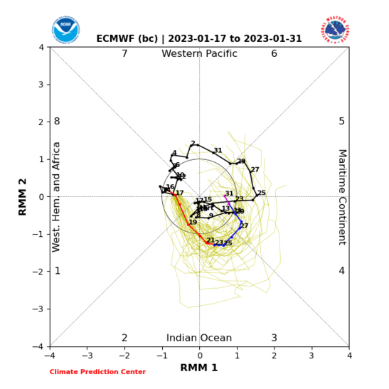


While I can see room for the MJO to make it a bit further before decaying, the overall signal from the above is for a bit more amplification by day 10 followed by a new round of amplification starting about two weeks from now as the MJO redevelops in phase 6.


This raises the question - is the increased amplification signal what's causing the shortwave low to develop and stall further west on the GFS and GFSP op runs? 


A glance at the day 6 charts suggests otherwise;


GFSP appears to end up where it does as a result of the shortwave developing far more rapidly than it does on the ECM and UKMO op runs. Associated buckling of the jet slows the E/NE progression to a stall before it even reaches the UK.


GFS has the main Atlantic trough centred south of Greenland on day 6 as opposed to south of Iceland on the ECM op run or towards Scandinavia on the UKMO op run. Why has GFS done this, you ask? The simple answer is, I'm not sure!


JMA produces a combination of GFSP and GFS; faster shortwave development coupled with the main low extended further west... the outcome is as you'd expect - trough on day 8 furthest west of all the output.


Because of how the GFSP, GFS and JMA runs set the pattern up in favour of a ridge across Scandinavia, they are in strong disagreement with ECM and the quite similar GEM over the broad-scale evolution not just days 6-8 but for perhaps a week or more beyond as well.


I will have a look around in search of any updates from Fergie regarding Met Office thoughts.


If you have any problems or queries relating to TWO you can Email [email protected]

https://twitter.com/peacockreports 
2023's Homeland Extremes:
T-Max: 30.2°C 9th Sep (...!) | T-Min: -7.1°C 22nd & 23rd Jan | Wettest Day: 25.9mm 2nd Nov | Ice Days: 1 (2nd Dec -1.3°C in freezing fog)
Keep Calm and Forecast On
Quantum
07 January 2015 21:34:26


I assume you reckon that is something that may eventually come to our aid to some extent Q?


Originally Posted by: David M Porter 


Yeh, what I'm looking for is SE facing lows to hit the UK which the environment seems suitable for, even without anything to support a scandi or greenland high, the atlantic can drive the winds easterly if the lows are sufficiently weak. The ECM seems to be interested in that idea with the 240hr chart.


2023/2024 Snow days (approx 850hpa temp):
29/11 (-6), 30/11 (-6), 02/12 (-5), 03/12 (-5), 04/12 (-3), 16/01 (-3), 18/01 (-8), 08/02 (-5)

Total: 8 days with snow/sleet falling.

2022/2023 Snow days (approx 850hpa temp):

18/12 (-1), 06/03 (-6), 08/03 (-8), 09/03 (-6), 10/03 (-8), 11/03 (-5), 14/03 (-6)

Total: 7 days with snow/sleet falling.

2021/2022 Snow days (approx 850hpa temp):

26/11 (-5), 27/11 (-7), 28/11 (-6), 02/12 (-6), 06/01 (-5), 07/01 (-6), 06/02 (-5), 19/02 (-5), 24/02 (-7), 30/03 (-7), 31/03 (-8), 01/04 (-8)
Total: 12 days with snow/sleet falling.
Polar Low
07 January 2015 21:36:55

That one also needs watching that could be very nasty indeed!


Polar Low
07 January 2015 21:55:36

Unlikely Gav


 Shared  max 18.3 c


  10 January 1971Aber
(Gwynedd)*
27 January 1958Aber
(Gwynedd)*
26 January 2003Aboyne
(Aberdeenshire)
26 January 2003Inchmarlo
(Kincardineshire)


Not sure if we'll get an all time January record, but we could get a date record (like on NYD) and it's worth keeping an eye on Friday night's minimum temperatures, which could be record breaking as well.


Originally Posted by: Gavin P 

Zubzero
07 January 2015 22:29:53

Stormy in the far north, and wet n windy for most of us.


Funny thing with the very mild chart Polar Low posted above it look's much better for a colder spell to follow.


 to what we have now http://modeles.meteociel.fr/modeles/gfs/runs/2015010718/gfsnh-0-168.png?18

Zubzero
07 January 2015 23:03:02

18z is a horror show for cold 


Remove ads from site

Ads