Remove ads from site

Charmhills
02 February 2015 18:34:02

I think it fair to say the outlook is looking cold if not very cold for most for the foreseeable.


Loughborough, EM.

Knowledge is power, ignorance is weakness.

Duane.
SEMerc
02 February 2015 18:39:40

Thought ECM T+168 might make a stab towards Greenland. Alas, it looks like flattening out.

David M Porter
02 February 2015 18:39:40


I think it fair to say the outlook is looking cold if not very cold for most for the foreseeable.


Originally Posted by: Charmhills 


Indeed. It's certainly a big contrast to what we had a year ago.


Lenzie, Glasgow

"Let us not take ourselves too seriously. None of us has a monopoly on wisdom, and we must always be ready to listen and respect other points of view."- Queen Elizabeth II 1926-2022
SEMerc
02 February 2015 18:44:39

Yep, flat as a pancake at T+192 with strong WNW.

Solar Cycles
02 February 2015 18:48:11


Well you'll probably guess I'm not buying it at this time. It will take a monumental shift from the 00Z and 06Z ENS set to get that high far enough West and North to bring the Arctic in again ('again' used loosely)

Not saying it won't but it would be very unusual.


Originally Posted by: nsrobins 

Indeed, I don't really see what all the excitement is for, yes it will be cold but mainly dry for many as the week progresses. All I see is a fairly cold 10 days or so before the high sinks slowly allowing a less cold W/NW airflow back in.

cultman1
02 February 2015 18:52:41
I am not sure you are right judging by what I have read elsewhere and just seenon the BBC weather news. I dont call a windchill here in London of -1 fairly cold even if the temperature got to 3 degrees today. It is looking similar for the rest of this week and weekend.....
Solar Cycles
02 February 2015 18:56:21

I am not sure you are right judging by what I have read elsewhere and just seenon the BBC weather news. I dont call a windchill here in London of -1 fairly cold even if the temperature got to 3 degrees today. It is looking similar for the rest of this week and weekend.....

Originally Posted by: cultman1 

In London I'm talking nationwide and as the week progresses I think maximum temps will range from 3-6c.

Quantum
02 February 2015 18:58:01

Very odd solution from the ECM, probably worth ignoring. 


2023/2024 Snow days (approx 850hpa temp):
29/11 (-6), 30/11 (-6), 02/12 (-5), 03/12 (-5), 04/12 (-3), 16/01 (-3), 18/01 (-8), 08/02 (-5)

Total: 8 days with snow/sleet falling.

2022/2023 Snow days (approx 850hpa temp):

18/12 (-1), 06/03 (-6), 08/03 (-8), 09/03 (-6), 10/03 (-8), 11/03 (-5), 14/03 (-6)

Total: 7 days with snow/sleet falling.

2021/2022 Snow days (approx 850hpa temp):

26/11 (-5), 27/11 (-7), 28/11 (-6), 02/12 (-6), 06/01 (-5), 07/01 (-6), 06/02 (-5), 19/02 (-5), 24/02 (-7), 30/03 (-7), 31/03 (-8), 01/04 (-8)
Total: 12 days with snow/sleet falling.
Charmhills
02 February 2015 19:03:00


We end on a cold NW flow once more, wintry for northern parts.


Loughborough, EM.

Knowledge is power, ignorance is weakness.

Duane.
Quantum
02 February 2015 19:03:01

Continuing to see a trickle of very cold members on the ENS.


Yet another:


My definition of severity of a cold spell is something like this for 850s:


<-5: Moderate


<-10: Severe


<-15: Extreme


What I am seeing is a low risk of severe/borderline extreme incursions, but lots of them when looking at different runs and different times. This pattern has been going on for days now. 


I wonder how the met will deal with a solution that is probably benign but has a low chance of being severe/borderline extreme.


2023/2024 Snow days (approx 850hpa temp):
29/11 (-6), 30/11 (-6), 02/12 (-5), 03/12 (-5), 04/12 (-3), 16/01 (-3), 18/01 (-8), 08/02 (-5)

Total: 8 days with snow/sleet falling.

2022/2023 Snow days (approx 850hpa temp):

18/12 (-1), 06/03 (-6), 08/03 (-8), 09/03 (-6), 10/03 (-8), 11/03 (-5), 14/03 (-6)

Total: 7 days with snow/sleet falling.

2021/2022 Snow days (approx 850hpa temp):

26/11 (-5), 27/11 (-7), 28/11 (-6), 02/12 (-6), 06/01 (-5), 07/01 (-6), 06/02 (-5), 19/02 (-5), 24/02 (-7), 30/03 (-7), 31/03 (-8), 01/04 (-8)
Total: 12 days with snow/sleet falling.
Quantum
02 February 2015 19:05:54

Here's another one.


Again like I have been saying, it would seem like there is a low probability of something like this happening at any one time, but integrated over a large time period, one has to wonder...


Jesus how many of these things are there.


2023/2024 Snow days (approx 850hpa temp):
29/11 (-6), 30/11 (-6), 02/12 (-5), 03/12 (-5), 04/12 (-3), 16/01 (-3), 18/01 (-8), 08/02 (-5)

Total: 8 days with snow/sleet falling.

2022/2023 Snow days (approx 850hpa temp):

18/12 (-1), 06/03 (-6), 08/03 (-8), 09/03 (-6), 10/03 (-8), 11/03 (-5), 14/03 (-6)

Total: 7 days with snow/sleet falling.

2021/2022 Snow days (approx 850hpa temp):

26/11 (-5), 27/11 (-7), 28/11 (-6), 02/12 (-6), 06/01 (-5), 07/01 (-6), 06/02 (-5), 19/02 (-5), 24/02 (-7), 30/03 (-7), 31/03 (-8), 01/04 (-8)
Total: 12 days with snow/sleet falling.
Gooner
02 February 2015 19:13:04


Wishful thinking from the Control at the end


Remember anything after T120 is really Just For Fun


Marcus
Banbury
North Oxfordshire
378 feet A S L


sizzle
02 February 2015 19:16:41

whats going on with these charts are they over cooking things.

Quantum
02 February 2015 19:20:23


whats going on with these charts are they over cooking things.


Originally Posted by: sizzle 


No, the cold incursion is extremely cold, and taps in directly to the coldest pool in the entire northern hemisphere, those 850s are realistic, they show what will happen if the HP is shifted slightly west. There is a low probability of this happening, but not so low it should be dismissed as trivial. Its a nightmare forecast, high probability of quite cold, low probability of something quite severe (albeit temporary). 


2023/2024 Snow days (approx 850hpa temp):
29/11 (-6), 30/11 (-6), 02/12 (-5), 03/12 (-5), 04/12 (-3), 16/01 (-3), 18/01 (-8), 08/02 (-5)

Total: 8 days with snow/sleet falling.

2022/2023 Snow days (approx 850hpa temp):

18/12 (-1), 06/03 (-6), 08/03 (-8), 09/03 (-6), 10/03 (-8), 11/03 (-5), 14/03 (-6)

Total: 7 days with snow/sleet falling.

2021/2022 Snow days (approx 850hpa temp):

26/11 (-5), 27/11 (-7), 28/11 (-6), 02/12 (-6), 06/01 (-5), 07/01 (-6), 06/02 (-5), 19/02 (-5), 24/02 (-7), 30/03 (-7), 31/03 (-8), 01/04 (-8)
Total: 12 days with snow/sleet falling.
sizzle
02 February 2015 19:24:11


No, the cold incursion is extremely cold, and taps in directly to the coldest pool in the entire northern hemisphere, those 850s are realistic, they show what will happen if the HP is shifted slightly west. There is a low probability of this happening, but not so low it should be dismissed as trivial. Its a nightmare forecast, high probability of quite cold, low probability of something quite severe (albeit temporary). 


Originally Posted by: Quantum 

thanks quantum, so sit wait and watch ,  great live forecast the other night   hope another 1 soon,

The Beast from the East
02 February 2015 19:36:53

Insane ECM. As Q says, bin it


"We have some alternative facts for you"
Kelly-Ann Conway - special adviser to the President
Stormchaser
02 February 2015 19:44:08

I'm afraid I'm in a technical mood tonight guys... you have been warned 


The background drivers (AAM, GWO - driven by Mountain Torque [MT] events - and perhaps the MJO) are looking behave almost identically to how they did prior to the cold spell we're currently in. As Tamara posted this morning:


"...we get some assistance (repeat circuit of late Jan) from another +EAMT for vortex movement to our side of the pole (GWO 4/5) and then we get a subsequent -MT for upstream Atlantic amplification (Phases 8/1/2)."


Based on this, you'd expect to see a major trough dropping down just east of the UK with the Azores/Mid Atlantic high taking a hike west and then north.


The fact that we have ended up following such a pattern this past week represents a significant win for anticipating the future direction of travel using those background drivers.


With the models trending toward an increasingly significant MJO event in phase 8, there may yet be another helping hand... perhaps a major one given how the February composite looks (below-left):
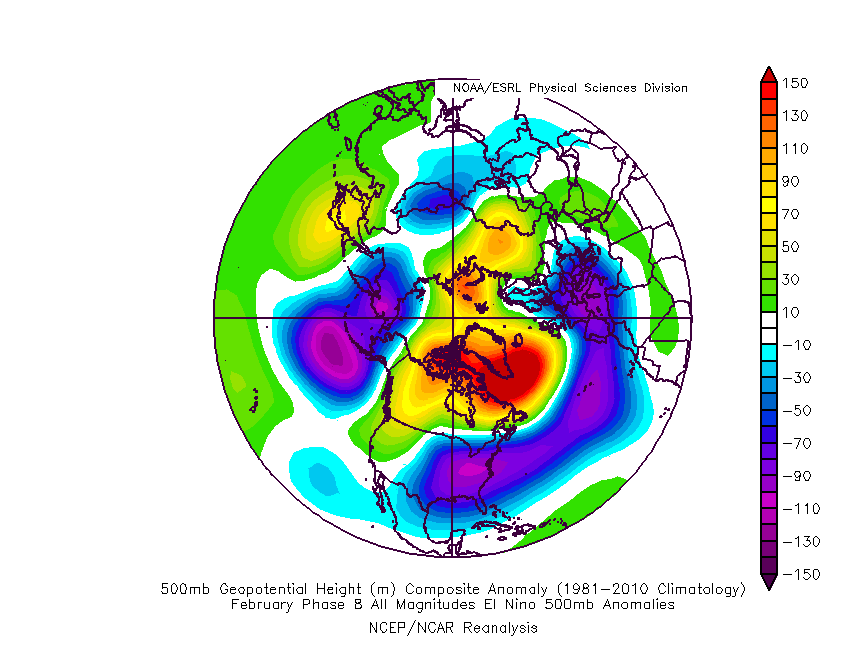

  Not Complete Yet


Imagine if that came through strongly! 


Above-right is the GWO outlook based on the GEFS mean. It starts at the yellow start and heads into phase 5 - which signals that positive East Asian Mountain Torque event that Tamara mentions - followed by a path to phases 8 to 2 - which signals a negative MT event.


These Asian MT events initiate shifts in the jet stream intensity and latitudinal positioning (how far N or S) that begin in the Pacific and then translate to the Atlantic. As the Atlantic has two main jets (subtropical and polar), we tend to see a change in the balance of strength between these rather than an overall strengthening or weakening of both.


The sequence of events predicted should cause the subtropical jet to weaken the Azores High and, in conjunction with the polar vortex being pushed out of Greenland toward Scandinavia (thanks to impacts that the MT events have on the higher levels of the atmosphere including the stratosphere), favour a mid-Atlantic high to our W or NW.


In light of all this, ECM seems the most sensible solution in terms of what it at least tries to do. The main problem occurs days 9-10, when the subtropical jet is phased with the polar jet, which tends to work out poorly for us in terms of getting the diving trough into Europe.


On the other hand, we see the Pacific trough edge west, with a strong ridge into the western U.S., which is a good step toward producing the required Atlantic amplification a few days later. See the GEM 12z for an illustration of this (http://www.theweatheroutlook.com/twodata/datmdlout.aspx - select GEM tab).


It all comes down to a timing issue really - can we see enough amplification soon enough to repeat the Euro trough scenario soon enough to be effective UK-wide? I'm thinking this will be a tough ask unless we see some strong ridging to the high latitudes from the Atlantic or, better still, high latitude blocking, to feed a greater amount of very cold air down across the UK.


Runs like today's ECM 12z were followed by a substantial increase in amplification to produce what we currently have, and this was after GFS kept on producing Euro Highs, so there's a chance that we'll see similar behaviour again this time. That GFS has been showing mid-latitude highs this time around could suggest greater potential for ridging to higher latitudes... but this is probably reading too much into it.


If you have any problems or queries relating to TWO you can Email [email protected]

https://twitter.com/peacockreports 
2023's Homeland Extremes:
T-Max: 30.2°C 9th Sep (...!) | T-Min: -7.1°C 22nd & 23rd Jan | Wettest Day: 25.9mm 2nd Nov | Ice Days: 1 (2nd Dec -1.3°C in freezing fog)
Keep Calm and Forecast On
sizzle
02 February 2015 19:47:57

dam storm chaser  that's all Chinese to me   very technical   but  great post need to get my head round this

Whether Idle
02 February 2015 19:55:23

The Brazilian model wants to sink the high relative to the ECM, less amplification.


Chinese model wants the same, again at odds with the ECM.


Dover, 5m asl. Half a mile from the south coast.
The Beast from the East
02 February 2015 21:18:38
ECM op mild outlier at day 10. if indeed it can be called "mild"
"We have some alternative facts for you"
Kelly-Ann Conway - special adviser to the President
BJBlake
02 February 2015 22:18:03

For the bemused newbie - whats MJO and AMM again? I get the rest, except the concept of Mountain Torque is a new one on me: Whats the mechanism?


Interesting locked in pattens of latter year G.Warming trend. Last year locked in wet, this year locked in faux cold: marginal for snow. Great to have a locked in 1947 - just once. Still waiting to be snowed in! Despite being warned on moving to Suffolk in1988, that I'd be snowed in 3 weeks of the year: I guess they'd just had 1979, 81,85 & 87 + 91 to call on as evidence. 28 years on  - give me a locked in polar vortex: Was it this that brought the 1888 blizzard from hell I wonder? Could it happen again. Talk is that this little ice age was in fact a little warm period, which precipitates locked in cold trends in NW europe and E USA (Dr. Dewpoint's theory)!


Just saying...


Brecklands, South Norfolk 28m ASL
Gusty
02 February 2015 22:28:34

A nicely constructed streamer of sorts for the Kent contingent for about 24-30 hours. Intensity isn't too great but convection is never modelled too well.


Modele GFS - Carte prévisions


Steve - Folkestone, Kent
Current conditions from my Davis Vantage Vue
https://www.wunderground.com/dashboard/pws/IFOLKE11 
Join Kent Weather on Facebook.
https://www.facebook.com/stevewall69/ 


Gooner
02 February 2015 23:03:24


The next 7 days weather now set up, dry and cold for most


Nice and seasonal


Remember anything after T120 is really Just For Fun


Marcus
Banbury
North Oxfordshire
378 feet A S L


Zubzero
02 February 2015 23:07:09

I'm gunning for the ECM and hope it is on to something


GFS is a yawn fest though will keep the CET a bit below avarage  

Matty H
02 February 2015 23:09:07

Total waste of gorgeous summer charts. 


Remove ads from site

Ads