Remove ads from site

Solar Cycles
01 January 2016 17:22:55
I'm failing to see anything remotely good in any output unless you like cold rain or live on a mountain in England and Wales, the N/NE Scotland could do well out of this set up but for the rest of us nothing but a cooler version of what we've been accustomed to (but with less in the way of heavy rain) for the next 10 days at least.
Quantum
01 January 2016 17:26:27

I'm failing to see anything remotely good in any output unless you like cold rain or live on a mountain in England and Wales, the N/NE Scotland could do well out of this set up but for the rest of us nothing but a cooler version of what we've been accustomed to (but with less in the way of heavy rain) for the next 10 days at least.

Originally Posted by: Solar Cycles 


One thing to note is that little area of low heights and low temperatures over Europe that moves into scandanavia and then into the N atlantic is cauing cyclogenesis near shetland (and the prospect of a polar low), that is weaker on the 12Z. Without that cold air pouring into the atlantic the block would be much stronger and less disrupted. That feature is small and will not be well handled by any of the medium range models.


Note that core of -22C uppers. If that takes a small diversion and does not end up over the ocean or is slightly smaller, the impact would be important. 


2023/2024 Snow days (approx 850hpa temp):
29/11 (-6), 30/11 (-6), 02/12 (-5), 03/12 (-5), 04/12 (-3), 16/01 (-3), 18/01 (-8), 08/02 (-5)

Total: 8 days with snow/sleet falling.

2022/2023 Snow days (approx 850hpa temp):

18/12 (-1), 06/03 (-6), 08/03 (-8), 09/03 (-6), 10/03 (-8), 11/03 (-5), 14/03 (-6)

Total: 7 days with snow/sleet falling.

2021/2022 Snow days (approx 850hpa temp):

26/11 (-5), 27/11 (-7), 28/11 (-6), 02/12 (-6), 06/01 (-5), 07/01 (-6), 06/02 (-5), 19/02 (-5), 24/02 (-7), 30/03 (-7), 31/03 (-8), 01/04 (-8)
Total: 12 days with snow/sleet falling.
nouska
01 January 2016 17:26:58


It could be, but I'd have thought they would have stated the boundaries if that's the case. The fact the chart is labelled for both 500 heights and surface pressure doesn't help either!


I'll have to check over the next few runs to see whether the control fits inside that range even when it's not an outlier. Hey, I get to say "as ever, more runs are needed" for the first time in many a year!


Originally Posted by: Retron 


This conversation finally explains the question I asked you - never looked at the Meteociel spreads and the IMO charts side by side. The spread charts is the same as this one, which does not have any mention of mslp. I guess they have just named it as it appears on the op runs.


Just to add, there is a separate chart with the MSLP deviations colour coded. The hi-res is the dashed lines in this instance.


Solar Cycles
01 January 2016 17:33:15


One thing to note is that little area of low heights and low temperatures over Europe that moves into scandanavia and then into the N atlantic is cauing cyclogenesis near shetland (and the prospect of a polar low), that is weaker on the 12Z. Without that cold air pouring into the atlantic the block would be much stronger and less disrupted. That feature is small and will not be well handled by any of the medium range models.


Note that core of -22C uppers. If that takes a small diversion and does not end up over the ocean or is slightly smaller, the impact would be important. 


Originally Posted by: Quantum 

Yes it's one to watch Q. Keep up the optimism anyway, I enjoy reading your contributions they're always informative  with sound reasoning.👍

Brian Gaze
01 January 2016 17:40:51


Like you & others have noted, the turd in the chocolate cake in this instance has been the inability of lows to slide SE'wards into mainland Europe. I don't have enough knowledge to know what the reason for this has been (especially when very knowledgeable people gave detailed explanations of why undercutting should happen), but would love there to be a sort of post mortem on how this potential cold spell has disappeared into more autumn (for most of the UK)


Originally Posted by: Saint Snow 


I posted a chart recently which showed there has been a trend towards higher 500mB heights over Europe and lower heights to the northwest of the UK since the 1950s. This obviously suggests a change in the global circulation has occurred but answering whether it is temporary or permanent shift is for someone above my paygrade. 


Brian Gaze
Berkhamsted
TWO Buzz - get the latest news and views 
"I'm not socialist, I know that. I don't believe in sharing my money." - Gary Numan
Quantum
01 January 2016 17:44:58

The 12Z ensembles are very interesting, one of them full on makes it.
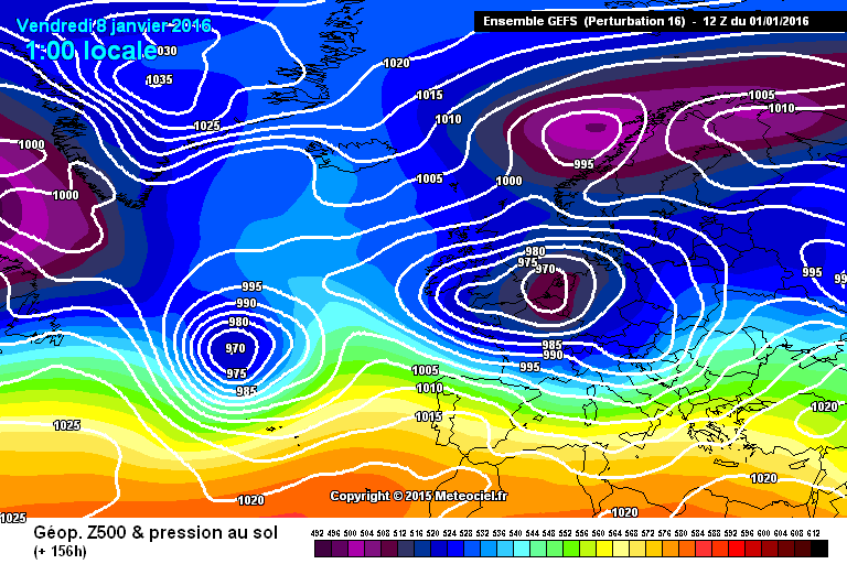


And a handful of others come close. I think the difference between a cold spell and not is still small, but just outside the range of the ensemble perturbations. The question is, can we get a bigger change than the perturbations? I think its possible, and we should not rule this out quite yet. 


Also how many times has a scandi high failed only for one to setup in Greenland. December could be ruled out in the 2nd week (why I was barely on the model thread then), but rule out January at your peril. 


When you discount all the ensembles that contain dartboard lows, the proportion that are close is actually high. 


And yes I think discounting dartboard lows is reasonable, how often do we see 930mb on the models, and how often does it actually come off?


2023/2024 Snow days (approx 850hpa temp):
29/11 (-6), 30/11 (-6), 02/12 (-5), 03/12 (-5), 04/12 (-3), 16/01 (-3), 18/01 (-8), 08/02 (-5)

Total: 8 days with snow/sleet falling.

2022/2023 Snow days (approx 850hpa temp):

18/12 (-1), 06/03 (-6), 08/03 (-8), 09/03 (-6), 10/03 (-8), 11/03 (-5), 14/03 (-6)

Total: 7 days with snow/sleet falling.

2021/2022 Snow days (approx 850hpa temp):

26/11 (-5), 27/11 (-7), 28/11 (-6), 02/12 (-6), 06/01 (-5), 07/01 (-6), 06/02 (-5), 19/02 (-5), 24/02 (-7), 30/03 (-7), 31/03 (-8), 01/04 (-8)
Total: 12 days with snow/sleet falling.
Shropshire
01 January 2016 17:45:54


I posted a chart recently which showed there has been a trend towards higher 500mB heights over Europe and lower heights to the northwest of the UK since the 1950s. This obviously suggests a change in the global circulation has occurred but answering whether it is temporary or permanent shift is for someone above my paygrade. 


Originally Posted by: Brian Gaze 


Well of course I would argue that never has this been more the case since 1988, particular when juxtaposed against the 1977-87 period.


As for a post-mortem on what is forthcoming, I don't think it necessary. The NWP has never at any time given a majority verdict on cold for the UK, as a veteran of some monumental let-downs and U turns, this doesn't even make the League table.


From December 27th 2020, zonality will be banned from mixing with the UK. We appreciate that this may come as a shock to younger people and old Uncle Barty. This ban will last for a minimum of ten days.
Brian Gaze
01 January 2016 17:49:04

GEFS12z update.


Brian Gaze
Berkhamsted
TWO Buzz - get the latest news and views 
"I'm not socialist, I know that. I don't believe in sharing my money." - Gary Numan
Quantum
01 January 2016 17:55:41

12Z ensemble watch:


Success (easterly in south): |||


Near miss (easterly in the north some energy SE): |||| 


Fail: ||||5 |||


Discounted for unrealistic 920mb lows: ||||5


But even the failures tend to increase heights over Greenland later.


2023/2024 Snow days (approx 850hpa temp):
29/11 (-6), 30/11 (-6), 02/12 (-5), 03/12 (-5), 04/12 (-3), 16/01 (-3), 18/01 (-8), 08/02 (-5)

Total: 8 days with snow/sleet falling.

2022/2023 Snow days (approx 850hpa temp):

18/12 (-1), 06/03 (-6), 08/03 (-8), 09/03 (-6), 10/03 (-8), 11/03 (-5), 14/03 (-6)

Total: 7 days with snow/sleet falling.

2021/2022 Snow days (approx 850hpa temp):

26/11 (-5), 27/11 (-7), 28/11 (-6), 02/12 (-6), 06/01 (-5), 07/01 (-6), 06/02 (-5), 19/02 (-5), 24/02 (-7), 30/03 (-7), 31/03 (-8), 01/04 (-8)
Total: 12 days with snow/sleet falling.
KevBrads1
01 January 2016 17:56:50


I posted a chart recently which showed there has been a trend towards higher 500mB heights over Europe and lower heights to the northwest of the UK since the 1950s. This obviously suggests a change in the global circulation has occurred but answering whether it is temporary or permanent shift is for someone above my paygrade. 


Originally Posted by: Brian Gaze 


Brian


Poor choice of words, there hasn't been a change in circulation pattern as I showed a chart from 1903 showing the mean February chart. The most that can be said is a strengthening in the circulation pattern.


MANCHESTER SUMMER INDEX for 2021: 238
Timelapses, old weather forecasts and natural phenomena videos can be seen on this site
http://www.youtube.com/channel/UCgrSD1BwFz2feWDTydhpEhQ/playlists
KevBrads1
01 January 2016 18:12:56

Just clear this up. There has not been a change in circulation patterns. What the debate is about the strengthening and weakening of global patterns and what may cause this.


To show this here is the January mean chart from a book I have dated from the late 1950s


UserPostedImage


MANCHESTER SUMMER INDEX for 2021: 238
Timelapses, old weather forecasts and natural phenomena videos can be seen on this site
http://www.youtube.com/channel/UCgrSD1BwFz2feWDTydhpEhQ/playlists
Shropshire
01 January 2016 18:33:22


Just clear this up. There has not been a change in circulation patterns. What the debate is about the strengthening and weakening of global patterns and what may cause this.


To show this here is the January mean chart from a book I have dated from the late 1950s


UserPostedImage


Originally Posted by: KevBrads1 


I think this chart is shown as a 'most common' NW Europe winter chart - plenty of winters in the fifties saw charts very different to that, certainly more variation than we are seeing right now.


From December 27th 2020, zonality will be banned from mixing with the UK. We appreciate that this may come as a shock to younger people and old Uncle Barty. This ban will last for a minimum of ten days.
KevBrads1
01 January 2016 18:40:50


I think this chart is shown as a 'most common' NW Europe winter chart - plenty of winters in the fifties saw charts very different to that, certainly more variation than we are seeing right now.


Originally Posted by: Shropshire 


Thats the mean chart back then for January. Most common is the mean, if you think about it. Yes there were variations to this but the fact remains that was even then still the mean January chart. My point is the debate should be on the strength of this pattern.


To go even further back to 1903 and here are three charts depicting on the left, a normal Feb, Feb 1903 and Feb 1895. Look at the norm Feb chart back then.


UserPostedImage


MANCHESTER SUMMER INDEX for 2021: 238
Timelapses, old weather forecasts and natural phenomena videos can be seen on this site
http://www.youtube.com/channel/UCgrSD1BwFz2feWDTydhpEhQ/playlists
Gandalf The White
01 January 2016 18:46:10


Just clear this up. There has not been a change in circulation patterns. What the debate is about the strengthening and weakening of global patterns and what may cause this.


To show this here is the January mean chart from a book I have dated from the late 1950s


UserPostedImage


Originally Posted by: KevBrads1 


I think this is a classic example of weather v climate.  That chart shows the typical synoptic pattern for January and I agree that nothing significant has changed.  It's this pressure distribution that delivers predominantly changeable, relatively mild (for our latitide) conditions and reflects us being on the eastern edge of a huge ocean and on the western edge of a great continent.


I recall many winters where Bartlett highs were the norm and/or a rajing jet ran straight over the top and into Scandinavia.  Occasionally, as we all know, we get blocks delivering temporary Arctic airmasses but they're seldom long-lasting.  I guess that's why there's something magical about an Arctic freeze and why many of us spend time in the winter months hunting for signs of one.


Back on topic, this chart isn't a million miles from the one in your 1950s book:


Deep low pressure in our vicinity looks almost inevitable for the next week or so.


Location: South Cambridgeshire
130 metres ASL
52.0N 0.1E


Quantum
01 January 2016 19:45:23

occ


Not sure how reliable 850s are when the pressure is this low, and strong occlusions are very lenient in terms of temp requirements anyway. The point is a 50 mile shift and a slightly colder environment could mean 20cm of snow for the NE.


2023/2024 Snow days (approx 850hpa temp):
29/11 (-6), 30/11 (-6), 02/12 (-5), 03/12 (-5), 04/12 (-3), 16/01 (-3), 18/01 (-8), 08/02 (-5)

Total: 8 days with snow/sleet falling.

2022/2023 Snow days (approx 850hpa temp):

18/12 (-1), 06/03 (-6), 08/03 (-8), 09/03 (-6), 10/03 (-8), 11/03 (-5), 14/03 (-6)

Total: 7 days with snow/sleet falling.

2021/2022 Snow days (approx 850hpa temp):

26/11 (-5), 27/11 (-7), 28/11 (-6), 02/12 (-6), 06/01 (-5), 07/01 (-6), 06/02 (-5), 19/02 (-5), 24/02 (-7), 30/03 (-7), 31/03 (-8), 01/04 (-8)
Total: 12 days with snow/sleet falling.
The Beast from the East
01 January 2016 20:39:19
Yes. Jam in 10 days time. Except the Jam is always 10 days away.
"We have some alternative facts for you"
Kelly-Ann Conway - special adviser to the President
Saint Snow
01 January 2016 20:47:24

Wouldn't it be funny if the gfs 12z was setting a trend, with all models re-showing CAA westwards & a cold easterly spell in subsequent runs. Steve Murr would be sainted 


Martin
Home: St Helens (26m asl) Work: Manchester (75m asl)
A TWO addict since 14/12/01
"How can wealth persuade poverty to use its political freedom to keep wealth in power? Here lies the whole art of Conservative politics."
Aneurin Bevan
Quantum
01 January 2016 21:01:24

GFS parallel is trending cold.


2023/2024 Snow days (approx 850hpa temp):
29/11 (-6), 30/11 (-6), 02/12 (-5), 03/12 (-5), 04/12 (-3), 16/01 (-3), 18/01 (-8), 08/02 (-5)

Total: 8 days with snow/sleet falling.

2022/2023 Snow days (approx 850hpa temp):

18/12 (-1), 06/03 (-6), 08/03 (-8), 09/03 (-6), 10/03 (-8), 11/03 (-5), 14/03 (-6)

Total: 7 days with snow/sleet falling.

2021/2022 Snow days (approx 850hpa temp):

26/11 (-5), 27/11 (-7), 28/11 (-6), 02/12 (-6), 06/01 (-5), 07/01 (-6), 06/02 (-5), 19/02 (-5), 24/02 (-7), 30/03 (-7), 31/03 (-8), 01/04 (-8)
Total: 12 days with snow/sleet falling.
Quantum
01 January 2016 21:05:33

Wow, thundersnow if this comes off, lake effect from the west.


OK I'll say it, shades of 1984 


2023/2024 Snow days (approx 850hpa temp):
29/11 (-6), 30/11 (-6), 02/12 (-5), 03/12 (-5), 04/12 (-3), 16/01 (-3), 18/01 (-8), 08/02 (-5)

Total: 8 days with snow/sleet falling.

2022/2023 Snow days (approx 850hpa temp):

18/12 (-1), 06/03 (-6), 08/03 (-8), 09/03 (-6), 10/03 (-8), 11/03 (-5), 14/03 (-6)

Total: 7 days with snow/sleet falling.

2021/2022 Snow days (approx 850hpa temp):

26/11 (-5), 27/11 (-7), 28/11 (-6), 02/12 (-6), 06/01 (-5), 07/01 (-6), 06/02 (-5), 19/02 (-5), 24/02 (-7), 30/03 (-7), 31/03 (-8), 01/04 (-8)
Total: 12 days with snow/sleet falling.
The Beast from the East
01 January 2016 21:06:40
If Murr gives Cameron a big enough donation, he'll be knighted let alone Sainted! But on topic, slightly more promising runs this evening
"We have some alternative facts for you"
Kelly-Ann Conway - special adviser to the President
Quantum
01 January 2016 21:12:36

Returning to my 500hpa temp analysis 


This to me says it all, in fact I don't really know where the polar vortex is, there are pieces of it everywhere. Unbelievably the strongest piece is actually over the East china sea. There is a huge chunk bitten out of it in Alaska too. Something is stiring in the dark. 


2023/2024 Snow days (approx 850hpa temp):
29/11 (-6), 30/11 (-6), 02/12 (-5), 03/12 (-5), 04/12 (-3), 16/01 (-3), 18/01 (-8), 08/02 (-5)

Total: 8 days with snow/sleet falling.

2022/2023 Snow days (approx 850hpa temp):

18/12 (-1), 06/03 (-6), 08/03 (-8), 09/03 (-6), 10/03 (-8), 11/03 (-5), 14/03 (-6)

Total: 7 days with snow/sleet falling.

2021/2022 Snow days (approx 850hpa temp):

26/11 (-5), 27/11 (-7), 28/11 (-6), 02/12 (-6), 06/01 (-5), 07/01 (-6), 06/02 (-5), 19/02 (-5), 24/02 (-7), 30/03 (-7), 31/03 (-8), 01/04 (-8)
Total: 12 days with snow/sleet falling.
The Beast from the East
01 January 2016 21:13:53
Is the cold blob SST anomaly in the north atlantic still there? If so we might do better than usual out of this set up
"We have some alternative facts for you"
Kelly-Ann Conway - special adviser to the President
Quantum
01 January 2016 21:17:53

12Z parallel high res ends with heavy snow showers for the NW, and cold everywhere. 


2023/2024 Snow days (approx 850hpa temp):
29/11 (-6), 30/11 (-6), 02/12 (-5), 03/12 (-5), 04/12 (-3), 16/01 (-3), 18/01 (-8), 08/02 (-5)

Total: 8 days with snow/sleet falling.

2022/2023 Snow days (approx 850hpa temp):

18/12 (-1), 06/03 (-6), 08/03 (-8), 09/03 (-6), 10/03 (-8), 11/03 (-5), 14/03 (-6)

Total: 7 days with snow/sleet falling.

2021/2022 Snow days (approx 850hpa temp):

26/11 (-5), 27/11 (-7), 28/11 (-6), 02/12 (-6), 06/01 (-5), 07/01 (-6), 06/02 (-5), 19/02 (-5), 24/02 (-7), 30/03 (-7), 31/03 (-8), 01/04 (-8)
Total: 12 days with snow/sleet falling.
David M Porter
01 January 2016 21:22:55

Yes. Jam in 10 days time. Except the Jam is always 10 days away.

Originally Posted by: The Beast from the East 


I've always been a big believer in the saying "The proof of the pudding is in the eating of it". We can forget about any major change to the unsettled pattern for the next 10 days at least. The only change from recent weather will be the less mild feel over many areas of the UK compared to what we saw in November & especially December.


Later in January may prove to be more interesting- we shall see. Time will tell as always.


Lenzie, Glasgow

"Let us not take ourselves too seriously. None of us has a monopoly on wisdom, and we must always be ready to listen and respect other points of view."- Queen Elizabeth II 1926-2022
snow 2004
01 January 2016 21:45:31


Wow, thundersnow if this comes off, lake effect from the west.


OK I'll say it, shades of 1984 


Originally Posted by: Quantum 


That would be brilliant for here. We had a good few hail and thundersnow events last winter from cold windy W/NW setups. Big towering clouds crashing into the Pennines. 


Glossop Derbyshire, 200m asl

Remove ads from site

Ads