As chair-toppling as the longer-range charts from ECM in particular are this evening, it's the progress in the 120-144 hour range that pleases me most, for we now have agreement that the trough over the U.S. will be amplified enough to support the ridge in the mid-Atlantic without shortwaves getting in the way, which also has the effect of placing the trough right in the way of the Arctic High's attempts to link with a Canadian/Alaskan ridge for example.
That's what sets the stage for the Arctic High to Mid-Atlantic High linkup during the following days, which ECM takes to the extreme while GFS shows us that even when there's pressure from the Atlantic, such a combination is capable of holding firm for day after day as an extended ridge from the Atlantic, as cold, unstable air is drawn down across Scandinavia and Europe to help maintain a broad trough there.
Further support for the day 5-6 outcome can be found from the latest NCEP discussion:
LATEST GUIDANCE MAINTAINS THE STATUS QUO WITH RESPECT TO THE EXPECTED MEAN PATTERN THROUGH THE PERIOD. A BROAD UPR LOW OVER E-CNTRL CANADA WILL ANCHOR AN AMPLIFIED TROUGH THAT EXTENDS INTO THE LOWER 48 WHILE ANOTHER TROUGH PERSISTS OVER THE E-CNTRL PACIFIC. BUNDLES OF ENERGY EJECTING FROM THIS LATTER TROUGH WILL HEAD INTO/PASS THROUGH A MEAN RIDGE NEAR THE WEST COAST.
The bold part is the key to success and is stated in no uncertain terms, despite the huge uncertainty that was referred to yesterday. That really says something about how well supported the newly emerged agreement is by the teleconnection signals, as usually such sudden changes are viewed with more skepticism.
The main question in my mind is, have we reached the peak of the model output in terms of quality? In terms of ECM's op runs, maybe (what a huge jump that model has made!), but GFS could perhaps move closer to that ECM run so there's a chance that the output could become even more exciting as the 18z and/or 00z GFS op runs roll out.
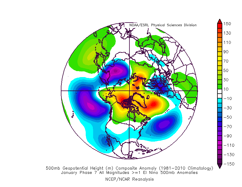
The assumption of a model peak prior to the actual event is based on the tendency to make the pattern too 'clean' at the longer range, with actual transitions tending to be more gradual. I wonder how valid that is on this occasion though, given the strong signal from the MJO in particular. Nick S. has stated on the other site that his usual skepticism is overturned by the fact that an amplified MJO in phase 7 during an El Nino year (as it is right now) has particularly strong effects on our part of the world, that being to raise heights to our N and NW.
The analogues show this well, and you can see the similarities with the 12z ECM on the Atlantic side:


What a day it has been. My sensible hat is at risk of being blown away.
If you have any problems or queries relating to TWO you can Email
[email protected] https://twitter.com/peacockreports 2023's Homeland Extremes:
T-Max: 30.2°C 9th Sep (...!) | T-Min: -7.1°C 22nd & 23rd Jan | Wettest Day: 25.9mm 2nd Nov | Ice Days: 1 (2nd Dec -1.3°C in freezing fog)
Keep Calm and Forecast On