Remove ads from site

Bertwhistle
31 January 2016 07:30:43

Not bad on GFS- depends what you want from t, I suppose but it's a far cry from the endless 5C+ uppers dross of December. This wintry map is only a week away. When does FI start- is it post 120?


http://www.theweatheroutlook.com/twodata/chart.aspx?chart=/charts/gfs/00_168_preciptype.png?cb=450


In contrast: http://www.theweatheroutlook.com/twodata/chart.aspx?chart=/charts/gefs/gefsens850brighton0.png?cb=11


13C uppers over Brighton. High for early Feb.


Bertie, Itchen Valley.
Retire while you can still press the 'retire now' button.
Bertwhistle
31 January 2016 07:46:09

Can anybody tell me where the PV is on this chart? Is it that little low E of Canada?


http://www.theweatheroutlook.com/twodata/chart.aspx?chart=/charts/ecm/144_mslp850.png?cb=882


Bertie, Itchen Valley.
Retire while you can still press the 'retire now' button.
White Meadows
31 January 2016 07:48:21
A true wintry blast now starting to feature in the extended output. Will this be winters last chance saloon? It would tie in with what met office have been writing about since November.
Those hoping for an early spring might have to keep the gloves hats and scarves handy or a while yet.
Cool, then cold then even colder as we approach mid Feb.
I think the switch is now showing.
Gooner
31 January 2016 08:10:48

A true wintry blast now starting to feature in the extended output. Will this be winters last chance saloon? It would tie in with what met office have been writing about since November.
Those hoping for an early spring might have to keep the gloves hats and scarves handy or a while yet.
Cool, then cold then even colder as we approach mid Feb.
I think the switch is now showing.

Originally Posted by: White Meadows 


I agree , the 18z started to show different options ,hopefully the Met have been very accurate


Remember anything after T120 is really Just For Fun


Marcus
Banbury
North Oxfordshire
378 feet A S L


Nick Gilly
31 January 2016 08:12:46
Not sure about winter returning but I am more concerned about that nasty secondary low showing on the GFS for February 6th. It's still 6 days away yet but if those charts verified the south would get a real battering.
Whether Idle
31 January 2016 08:15:39

A true wintry blast now starting to feature in the extended output. Will this be winters last chance saloon? It would tie in with what met office have been writing about since November.
Those hoping for an early spring might have to keep the gloves hats and scarves handy or a while yet.
Cool, then cold then even colder as we approach mid Feb.
I think the switch is now showing.

Originally Posted by: White Meadows 


I am in agreement, I think we are going to need to wait a further week or perhaps two at least before writing off the winter, as you suggest White Meadows.


I think it will be next week when the first signs may start to appear in FI. 


As Ive said before, one week of cold with a fall of snow that hangs about for a few days would rescue this winter for me from the reject pile.  The modal average for days of laying snow is zero, zilch, nothing for many areas.  In other words - a snowless winter, whilst not the norm, is the most common outcome in terms of days of laying snow.  Mean averages are dragged up by freak years such as 2010, 2005 IMBY, 1963, 1979, 1985 etc....My point being, that pre-conceived expectations perhaps should be set in advance at the modal average outcome (speaking from a southern urban perspective), and that any advance from zero for snowcover days in a winter is a bonus...


The models continue to show zonality as the favoured outcome, with just one breakaway option popping in this morning.  Plenty of time for this to change, and as an illustration, there are another 40 GFS runs between now and February 9th.


On the other hand, IF there is to be no cold spell in February, March can deliver both pleasant spring mildness and sparkling sunshine, as much as the earlier half can deliver the coldest weather of the winter period, March is often a fascinating period for model watching.


From a model watchers point of view, it really can be win-win. 


Dover, 5m asl. Half a mile from the south coast.
Gooner
31 January 2016 08:25:57


I am in agreement, I think we are going to need to wait a further week or perhaps two at least before writing off the winter, as you suggest White Meadows.


I think it will be next week when the first signs may start to appear in FI. 


As Ive said before, one week of cold with a fall of snow that hangs about for a few days would rescue this winter for me from the reject pile.  The modal average for days of laying snow is zero, zilch, nothing for many areas.  In other words - a snowless winter, whilst not the norm, is the most common outcome in terms of days of laying snow.  Mean averages are dragged up by freak years such as 2010, 2005 IMBY, 1963, 1979, 1985 etc....My point being, that pre-conceived expectations perhaps should be set in advance at the modal average outcome (speaking from a southern urban perspective), and that any advance from zero for snowcover days in a winter is a bonus...


The models continue to show zonality as the favoured outcome, with just one breakaway option popping in this morning.  Plenty of time for this to change, and as an illustration, there are another 40 GFS runs between now and February 9th.


On the other hand, IF there is to be no cold spell in February, March can deliver both pleasant spring mildness and sparkling sunshine, as much as the earlier half can deliver the coldest weather of the winter period, March is often a fascinating period for model watching.


From a model watchers point of view, it really can be win-win. 


Originally Posted by: Whether Idle 


They can indeed, but from the off the talk has always been for a colde second half which includes March. Those wanting Spring warmth might have had it ..........................in December


Remember anything after T120 is really Just For Fun


Marcus
Banbury
North Oxfordshire
378 feet A S L


Gooner
31 January 2016 08:42:03


Deep deep into FI I know, but so much potential


Remember anything after T120 is really Just For Fun


Marcus
Banbury
North Oxfordshire
378 feet A S L


KevBrads1
31 January 2016 08:43:56


NOT!!!!!!!!!!!!!!


MANCHESTER SUMMER INDEX for 2021: 238
Timelapses, old weather forecasts and natural phenomena videos can be seen on this site
http://www.youtube.com/channel/UCgrSD1BwFz2feWDTydhpEhQ/playlists
doctormog
31 January 2016 08:52:39
One thing about which there is excellent model agreement is the worryingly strong winds for northern parts on Monday night. Another sleepless night wondering about power outages and more weather damage for a swathe of the country.

I wouldn't rule out another red warning (for the Western Isles)
Gooner
31 January 2016 08:53:04

Maybe March and April will be a repeat of 1975 , that would be most welcome


Remember anything after T120 is really Just For Fun


Marcus
Banbury
North Oxfordshire
378 feet A S L


Gooner
31 January 2016 08:55:09

One thing about which there is excellent model agreement is the worryingly strong winds for northern parts on Monday night. Another sleepless night wondering about power outages and more weather damage for a swathe of the country.

I wouldn't rule out another red warning (for the Western Isles)

Originally Posted by: doctormog 


And later in the week for the far North , looks destructive


Remember anything after T120 is really Just For Fun


Marcus
Banbury
North Oxfordshire
378 feet A S L


Windy Willow
31 January 2016 09:23:39


NOT!!!!!!!!!!!!!!


Originally Posted by: KevBrads1 


It can have th BFH!


South Holland, Lincs 5m/16ft ASL

Don't feed the Trolls!! When starved of attention they return to their dark caves or the dark recesses of bridges and will turn back to stone, silent again!
Ally Pally Snowman
31 January 2016 10:22:46

Massively unsettled sums it up but you can certainly see how a significant cold spell could turn up with charts like the day 10 ECM.


http://www.wetterzentrale.de/pics/Recm2401.html


Bishop's Stortford 85m ASL.
NickR
  • NickR
  • Advanced Member Topic Starter
31 January 2016 10:28:50

One thing about which there is excellent model agreement is the worryingly strong winds for northern parts on Monday night. Another sleepless night wondering about power outages and more weather damage for a swathe of the country.

I wouldn't rule out another red warning (for the Western Isles)

Originally Posted by: doctormog 


Indeed. It hasn't been downgraded. I've reinforced my fence with some support posts connected with batons.


Nick
Durham
[email protected]
Retron
31 January 2016 10:30:03


Massively unsettled sums it up but you can certainly see how a significant cold spell could turn up with charts like the day 10 ECM.


http://www.wetterzentrale.de/pics/Recm2401.html


Originally Posted by: Ally Pally Snowman 


Mmm, that's a long way off from bringing a significant cold spell - there's simply no cold air around. Plus there are lows waiting in the wings further west...


Frankly, when even the coldest ensemble members only bring highs of 3C or so for London, it's really not much to get excited about if you live down here.


My benchmark for spotting cold spells hasn't changed: it's still several runs in a row with multiple -10C 850 members, along with some showing ice days. The output at the moment doesn't meet the first crtieria, let alone the second!


Leysdown, north Kent
JACKO4EVER
31 January 2016 10:41:38


Mmm, that's a long way off from bringing a significant cold spell - there's simply no cold air around. Plus there are lows waiting in the wings further west...


Frankly, when even the coldest ensemble members only bring highs of 3C or so for London, it's really not much to get excited about if you live down here.


My benchmark for spotting cold spells hasn't changed: it's still several runs in a row with multiple -10C 850 members, along with some showing ice days. The output at the moment doesn't meet the first crtieria, let alone the second!


Originally Posted by: Retron 


Hurrah for a voice of reason. Very little on offer for the South, though I do contend parts of Scotland and the North may get some periods of snow (nothing unusual in that). As far as I can see its the odd frost thrown in against bouts of wind and rain- locally stormy in places.

The Beast from the East
31 January 2016 11:43:23


Mmm, that's a long way off from bringing a significant cold spell - there's simply no cold air around. Plus there are lows waiting in the wings further west...


Originally Posted by: Retron 


Imogen is going to hang around Scotland for a long time and the cold air pumped into the atlantic. Perhaps signs of northern blocking trying to build on the 06z.


"We have some alternative facts for you"
Kelly-Ann Conway - special adviser to the President
The Beast from the East
31 January 2016 11:45:28

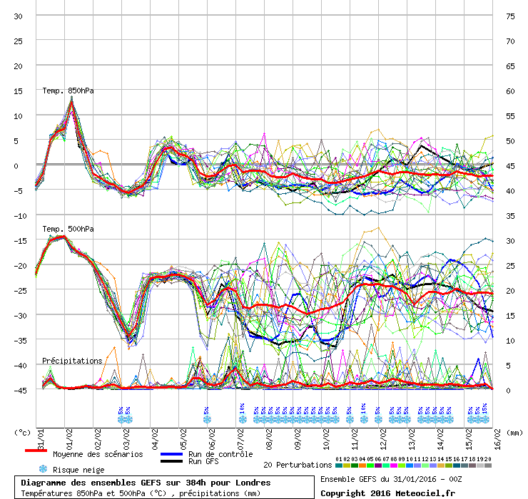
http://modeles7.meteociel.fr/modeles/gens/runs/2016013106/gens-0-1-288.png


GFS control. Once Imogen clears, we have a shot, and it maybe the last hurrah for the season


"We have some alternative facts for you"
Kelly-Ann Conway - special adviser to the President
Andy Woodcock
31 January 2016 11:55:09
Poor runs again but do I spot spring in the air on the GFS 06z for St Valentines day?

High pressure to the south east with a mild feed would be most welcome so I can get out in the garden and forget this dreadful winter.

Andy
Andy Woodcock
Penrith
Cumbria

Altitude 535 feet

"Why are the British so worried about climate change? Any change to their climate can only be an improvement" John Daley 2001
nsrobins
31 January 2016 11:56:21
I still can't see anything to change my thoughts that we have a robust form of cool zonality dominating for another 10 days with only transient HLB.
Neil
Fareham, Hampshire 28m ASL (near estuary)
Stormchaser, Member TORRO
Gooner
31 January 2016 12:04:01

Poor runs again but do I spot spring in the air on the GFS 06z for St Valentines day?

High pressure to the south east with a mild feed would be most welcome so I can get out in the garden and forget this dreadful winter.

Andy

Originally Posted by: Andy Woodcock 


At 5c I doubt it


Remember anything after T120 is really Just For Fun


Marcus
Banbury
North Oxfordshire
378 feet A S L


Gandalf The White
31 January 2016 12:15:19


Mmm, that's a long way off from bringing a significant cold spell - there's simply no cold air around. Plus there are lows waiting in the wings further west...


Frankly, when even the coldest ensemble members only bring highs of 3C or so for London, it's really not much to get excited about if you live down here.


My benchmark for spotting cold spells hasn't changed: it's still several runs in a row with multiple -10C 850 members, along with some showing ice days. The output at the moment doesn't meet the first crtieria, let alone the second!


Originally Posted by: Retron 


Agreed, but at least there's some interest in the charts.


Does anyone know when was the last time that southern England was under 500hPa heights below 500?  The T+216 charts are pretty close.


Cold, wet and windy is better, at least in terms of variety, than the slug-fest that was on offer not so long ago.


Location: South Cambridgeshire
130 metres ASL
52.0N 0.1E


Crepuscular Ray
31 January 2016 12:24:41


Maybe March and April will be a repeat of 1975 , that would be most welcome


Originally Posted by: Gooner 


Agreed! I lived in West Yorkshire on the eastern slopes of the Pennines and we had lots of days of beefy snow showers from the NE and E.


Jerry
Edinburgh, in the frost hollow below Blackford Hill
David M Porter
31 January 2016 12:37:24

Poor runs again but do I spot spring in the air on the GFS 06z for St Valentines day?

High pressure to the south east with a mild feed would be most welcome so I can get out in the garden and forget this dreadful winter.

Andy

Originally Posted by: Andy Woodcock 


Given our luck so far this winter Andy, I reckon there would be a greater chance of another rain fest a la December with the set-up you describe than a drier spell. The 384hr chart shows a set-up very similar to what we had throughout December.


Since it's in deep FI, it's not really worth losing any sleep over anyway, IMO.


Lenzie, Glasgow

"Let us not take ourselves too seriously. None of us has a monopoly on wisdom, and we must always be ready to listen and respect other points of view."- Queen Elizabeth II 1926-2022

Remove ads from site

Ads