Remove ads from site

Joe Bloggs
14 November 2024 13:27:40
06z ECM is another stunner. The block just gets more and more robust as we approach T+144. 
https://www.wetterzentrale.de/maps/ECMOPEU06_144_1.png  
With uppers like that, at face value that little low will no doubt bring snow to some. 

Manchester City Centre, 31m ASL

idj20
14 November 2024 15:35:07
Looking interesting wintry weather-wise for those over the northern half of the UK, especially high ground. But for us south coasters it'll be the same old with cold rain and wind, which sounds depressing after having been pleasantly mild, bright and dry today. 
Folkestone Harbour. 
Ally Pally Snowman
14 November 2024 16:28:30
Saint Snow
14 November 2024 16:46:21

Tuesday mornings snow not bad for here.
https://www.wetterzentrale.de/en/topkarten.php?map=20&model=gfs&var=25&run=12&time=111&lid=OP&h=0&mv=0&tr=3#mapref 

Originally Posted by: Ally Pally Snowman 


The 6z  was much better:  


Martin
Home: St Helens (26m asl) Work: Manchester (75m asl)
A TWO addict since 14/12/01
"How can wealth persuade poverty to use its political freedom to keep wealth in power? Here lies the whole art of Conservative politics."
Aneurin Bevan
Ally Pally Snowman
14 November 2024 17:03:57

The 6z  was much better:  


Originally Posted by: Saint Snow 


Indeed , it's not great compared to the 6z . Goes Pete Tong soon after as well.
Bishop's Stortford 85m ASL.
Hippydave
14 November 2024 17:20:11
12z GFS op show what can go wrong in the medium term, although it gives 5 days or so of colder weather over the UK (bit longer for the north) before the sinking HP ridge links up with the Azores HP and LP tracks over the top introducing milder air for all after a spell of transient snow for some.

I've not been taking detailed looks at the ens but I'd assume just from the scatter that it's been an option for a while, so presumably a case of the Op picking this solution this time. 

Will wait for the ens to see how well supported this is, along with ECM, UKMO and GEM runs. 


Home: Tunbridge Wells
Work: Tonbridge
doctormog
14 November 2024 17:33:05

12z GFS op show what can go wrong in the medium term, although it gives 5 days or so of colder weather over the UK (bit longer for the north) before the sinking HP ridge links up with the Azores HP and LP tracks over the top introducing milder air for all after a spell of transient snow for some.

I've not been taking detailed looks at the ens but I'd assume just from the scatter that it's been an option for a while, so presumably a case of the Op picking this solution this time. 

Will wait for the ens to see how well supported this is, along with ECM, UKMO and GEM runs. 

Originally Posted by: Hippydave 


The op run is definitely one of the milder options in the ensemble suite later in the run. By the 25th of November it is actually the mildest of all 30+ members for this location.
Hippydave
14 November 2024 17:38:38

The op run is definitely one of the milder options in the ensemble suite later in the run. By the 25th of November it is actually the mildest of all 30+ members for this location.

Originally Posted by: doctormog 


Cheers Michael. 

Acts as a cautionary note I guess but hopefully an unlikely outcome as it stands, ignoring the law of sod of course.
Home: Tunbridge Wells
Work: Tonbridge
Brian Gaze
14 November 2024 18:34:17
The hourly stepped GFS 12Z sequence is in this Tweet.
Static charts which this was generated from are here:

https://www.theweatheroutlook.com/twodata/gfs-hourly.aspx 


Brian Gaze
Berkhamsted
TWO Buzz - get the latest news and views 
"I'm not socialist, I know that. I don't believe in sharing my money." - Gary Numan
Rob K
14 November 2024 18:35:42
12Z GEFS showing the balance has definitely swung towards a shorter cold spell for the south. Begins on the 19th and all over bar the shouting by early on the 23rd.

Some runs prolong the cold but both op and control follow each other to the mild breakdown (unlike the 06Z when both went cold).

Plenty of time to swing back yet but the UKMO looks pretty poor for cold too, with the cold air never really arriving in the south and the Atlantic ready to break through rapidly at T144.

On a more positive note the 12Z GEFS has the highest snow percentage yet for London at 35%.
Yateley, NE Hampshire, 73m asl
"But who wants to be foretold the weather? It is bad enough when it comes, without our having the misery of knowing about it beforehand." — Jerome K. Jerome
Brian Gaze
14 November 2024 18:46:03


Plenty of time to swing back yet but the UKMO looks pretty poor for cold too, with the cold air never really arriving in the south and the Atlantic ready to break through rapidly at T144.

Originally Posted by: Rob K 


Really?  T168 shows a channel low.

UserPostedImage

Brian Gaze
Berkhamsted
TWO Buzz - get the latest news and views 
"I'm not socialist, I know that. I don't believe in sharing my money." - Gary Numan
Joe Bloggs
14 November 2024 18:53:54
Disappointing ECM for Monday. 
https://www.wetterzentrale.de/maps/ECMOPEU12_96_2.png 
Much colder later in the run. 

Manchester City Centre, 31m ASL

Tim A
14 November 2024 18:55:30
With GFS sending everything south I thought it was encouraging to see ECM North,  blended solution please.  
Tim
NW Leeds
187m asl

 My PWS 
CField
14 November 2024 19:01:15

Really?  T168 shows a channel low.

UserPostedImage

Originally Posted by: Brian Gaze 


Has the channel low been replaced by the Brussels runner lol
Favourite snowstorm
Famous channel low
Dec 31st 1978
Hastings East Sussex
Foot of level snow severe drifting
Next day max temp -4 degrees Celsius
Hippydave
14 November 2024 20:35:11
UserPostedImage
UKVs take on who gets lying snow from Monday/Tuesdays system FWIW (not a lot at that range!).  Other than that the run shows a fairly stereotypical shower distribution for the set up, unsurprisingly. 

Home: Tunbridge Wells
Work: Tonbridge
Joe Bloggs
14 November 2024 21:31:55

UserPostedImage
UKVs take on who gets lying snow from Monday/Tuesdays system FWIW (not a lot at that range!).  Other than that the run shows a fairly stereotypical shower distribution for the set up, unsurprisingly. 

Originally Posted by: Hippydave 


I don’t know of any model that is much good for lying snow. UKV can be good but a tad too conservative in my experience.  I miss EURO4! 

Manchester City Centre, 31m ASL

Rob K
14 November 2024 21:45:04

Really?  T168 shows a channel low.

UserPostedImage

Originally Posted by: Brian Gaze 


Not one that would give anything interesting though, and mild air rapidly piling in from the west courtesy of that big low in the Atlantic, from what I can see?

Met O and ECM look like little chance of anything properly wintry affecting the south, the blocking all heads into the continent with heights deserting Greenland. 
Yateley, NE Hampshire, 73m asl
"But who wants to be foretold the weather? It is bad enough when it comes, without our having the misery of knowing about it beforehand." — Jerome K. Jerome
Rob K
14 November 2024 22:29:36
A couple of days ago the weather apps had snow symbols and 4-5C early next week. Now it’s 10C on Monday and Tuesday followed by a couple of days of sunshine and 6C with temps down to about freezing overnight. 
The first of no doubt many occasions this winter where the models go off one before crashing back to reality…
Yateley, NE Hampshire, 73m asl
"But who wants to be foretold the weather? It is bad enough when it comes, without our having the misery of knowing about it beforehand." — Jerome K. Jerome
fullybhoy
14 November 2024 22:44:11

A couple of days ago the weather apps had snow symbols and 4-5C early next week. Now it’s 10C on Monday and Tuesday followed by a couple of days of sunshine and 6C with temps down to about freezing overnight. 
The first of no doubt many occasions this winter where the models go off one before crashing back to reality…

Originally Posted by: Rob K 


3c here on Monday and 2c for Tuesday according to the much maligned iPhone app!
Aldo
Glasgow 165m/asl
 
Karl Guille
15 November 2024 00:33:44
Certainly going to be noticeably colder down here into next week.
https://modeles16.meteociel.fr/modeles/gensp/runs/2024111418/graphe3_10000_223_246___.gif 

St. Sampson
Guernsey
Tim A
15 November 2024 06:47:25
Up to 9c here Monday on Met Office App, but pretty meaningless ATM, it says highest possible 19c, lowest possible -4c! 
Tim
NW Leeds
187m asl

 My PWS 
doctormog
15 November 2024 06:55:39
That is quite a drop in t850s here tomorrow:
UserPostedImage
Retron
15 November 2024 07:05:52
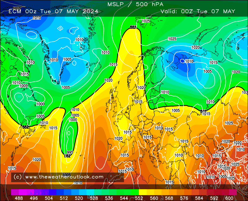
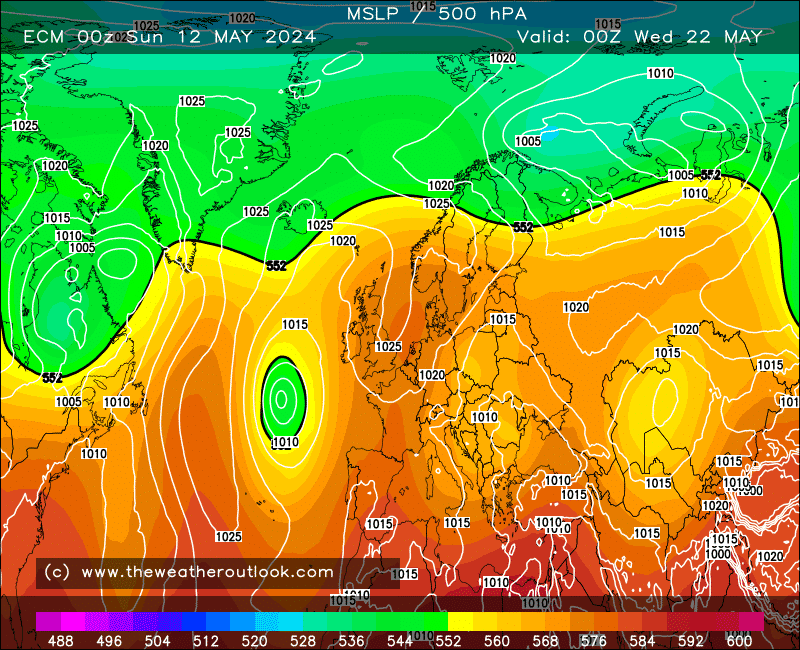
Today's ECM run is the textbook definition of an omega block.
We go from this at day 0 - an omega centred NW of the Azores:
UserPostedImage

...to this at day 10, the omega block having reformed over southern Greenland.
UserPostedImage
These are the "gold standard" blocks for cold fans, as they often repeat more than once - as we're seeing in the ECM run. The optimum position of the upper high is a bit further east than the 240 chart shows, but even so the UK is still under cold air on day 10.
One of these in the heart of winter would provide a memorable spell. At this time of year? Probably not, unless you have elevation, but that's the thing with marginal setups - you can often get unexpected snowfall locally, where just a few miles away it's cold rain.
Fascinating model watching, anyway, and I'll be very interested to see if other models can establish an omega block.
Leysdown, north Kent
Rob K
15 November 2024 07:12:49

Up to 9c here Monday on Met Office App, but pretty meaningless ATM, it says highest possible 19c, lowest possible -4c! 

Originally Posted by: Tim A 


The iPhone app now has Wed, Thursday and Friday as the only cold[font=system-ui, -apple-system, "Segoe UI", Roboto, "Helvetica Neue", "Noto Sans", "Liberation Sans", Arial, sans-serif, "Apple Color Emoji", "Segoe UI Emoji", "Segoe UI Symbol", "Noto Color Emoji"]ish days here (5C, 4C, 6C, with 0C overnight lows each night). 9C on Tuesday and back up to 11C by Friday. Zero precipitation on any of those colder days, either. [/font]

Very boring compared to the outlook a few days ago it must be said!

Yateley, NE Hampshire, 73m asl
"But who wants to be foretold the weather? It is bad enough when it comes, without our having the misery of knowing about it beforehand." — Jerome K. Jerome
Jiries
15 November 2024 07:14:23
Interesting read Darren and yes read about those omega blocks by Kita weather guy from Cyprus that feed cold air to the east med but this time our side.  Expect to see snow here and won’t be bone dry type as is very cold and unsettled.  At least the cold air early on should lower the North Atlantic sst temps quicker. 

Remove ads from site

Ads