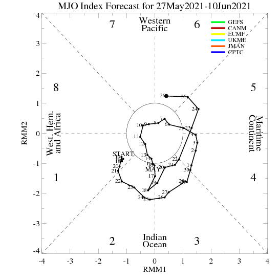
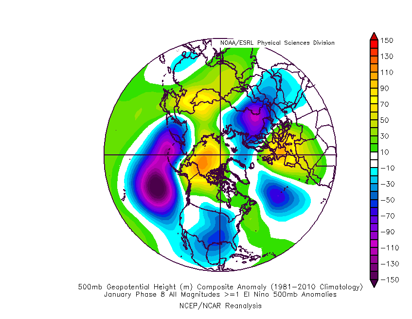
For those wondering why Euro Highs keep cropping up in GFS day 9 onward... the MJO conundrum continues to look like the main culprit:


The GFS operational now shows the decline of the MJO taking until phase 8 has been reached. Unlike back in December, this phase correlates to a strong positive height anomaly across Europe as can be seen above-right. You can even see a signal for low heights just west of the Azores which has also been turning up a lot in the GFS and GFSP runs.
Even at weak MJO amplitude the composite anomaly is so strong that a notable promotion of Euro Highs and Azores troughs is the likely response IF the GFS outlook for the MJO verifies.
By contrast, UKMO still has the MJO decaying in phase 6! That promotes a continuation of the Azores High tending to displace west and with troughs arriving from the NW. I did wonder if the 12z UKMO op run could still manage that from day 6, but cross-comparison reveals it to be very close to the ECM 00z op run, which was a good run for keeping that high displaced west, though not the best compared to the past few days, it has to be said.
ECM currently has the optimum MJO outlook, with a slow decay in phase 7 good for encouraging height rises to our NW and a general increase in high latitude blocking. This goes some way to explaining their recent persistence with a slowly sinking NW Europe trough for week 2, diverging strongly from GEFS. Having said that, the latest outlook does get close enough to phase 8 that some increase in the intensity of the subtropical jet could cause issues or at least interference such as appeared on the day 10 ECM 00z op run chart.
Finally, the raw GEFS output supports the GFS op strongly, but the bias corrected version is more like UKMO.
All this leaves me with no clear signal as to what is most likely to be the way forward. Obviously a halfway house between the two extremes (UKMO and GEFS) would be decent, but lately the MJO has been stronger and more progressive than most models have expected. GEFS have responded by shifting the decay to phase 8, but ECMF have remained solid on their phase 7 decay, and UKMO hasn't really shifted either.
If trends were to continue, ECM would start to show the decay being in phase 8 and the ensembles would become more like GEFS. Yet those GEFS would start to reflect a decay in phase 1, which promotes height rises to the NW, though potentially closer to the UK than Greenland. It will be an interesting and educational experience to see just how far the MJO actually ends up progressing before decay.
Mere speculation of course. With little movement from ECMF and UKMO despite corrections within the 24 hour range, it's possible that so such trend will occur in the first place. It depends how long the actual behaviour of the MJO continue to disagree with those two ensemble sets.
You may be wondering how I can be so sure that the MJO is a major player in all this. My answer has to be that I can't be absolutely sure, with my conclusions being based on the fact that the recent GEFS trend matches the trend in their MJO projections very closely, and the same goes for the ECM ensembles and their MJO projections. The correlation seems too strong to be mere coincidence.
I will have a read around to see if I can identify any other large-scale driving forces that could be responsible for these changes, or at least part of them. Most likely it would be a combination of that and the MJO if there is something.
Regardless, it seems that as far as conditions beyond about a week ahead are concerned, little faith can be placed in the entire ensemble suits of ECM and GEFS at this point in time.
While the models sort it out, there looks to be a lot of keep track of this coming week. Good timing I say! 
Edited by user
11 January 2015 18:26:37
|
Reason: a bit more detail
If you have any problems or queries relating to TWO you can Email
[email protected] https://twitter.com/peacockreports 2023's Homeland Extremes:
T-Max: 30.2°C 9th Sep (...!) | T-Min: -7.1°C 22nd & 23rd Jan | Wettest Day: 25.9mm 2nd Nov | Ice Days: 1 (2nd Dec -1.3°C in freezing fog)
Keep Calm and Forecast On