Remove ads from site

Brian Gaze
27 December 2019 08:37:31

Subtle changes in the output this morning but you wouldn't swing your cat around them. 


Brian Gaze
Berkhamsted
TWO Buzz - get the latest news and views 
"I'm not socialist, I know that. I don't believe in sharing my money." - Gary Numan
TimS
  • TimS
  • Advanced Member
27 December 2019 08:40:15
Disappointing surface temps during this warm spell, generally upper single figures instead of the mid teens or higher that the 850s imply.

Reminds me a bit of last June when we saw maxes in the mid 29s under record uppers because of the cool onshore flow from the North Sea.
Brockley, South East London 30m asl
nsrobins
27 December 2019 08:55:08

Disappointing surface temps during this warm spell, generally upper single figures instead of the mid teens or higher that the 850s imply.

Reminds me a bit of last June when we saw maxes in the mid 29s under record uppers because of the cool onshore flow from the North Sea.

Originally Posted by: TimS 


Given its a SSW flow I wouldn’t be surprised to see a 14 or 15C in lee of high ground - maybe Leith or Elgin for instance. 


Neil
Fareham, Hampshire 28m ASL (near estuary)
Stormchaser, Member TORRO
doctormog
27 December 2019 08:56:07

Disappointing surface temps during this warm spell, generally upper single figures instead of the mid teens or higher that the 850s imply.

Reminds me a bit of last June when we saw maxes in the mid 29s under record uppers because of the cool onshore flow from the North Sea.

Originally Posted by: TimS 


They should be higher over the weekend with the usual places impacted by an Föhn effect and perhaps values in the low teens. I would say Lossiemouth in Sunday may be a “hotspot”.


Generally the westerly theme continues with mild settled conditions mostly dominating but interspersed with less mild and more unsettled conditions. The coolest and most unsettled conditions being more likely further north.


Hippydave
27 December 2019 09:19:05

Hmmm all a bit uninspiring if you ask me.


If you're a coldie then seems like the best you can hope for is a bit more amplification in the pattern allowing more of a Northerly influence between LP systems (once the HP to our South moves somewhat).


The GFS postage stamps right to the end of the run strongly back the unsettled theme with HP to our south or south west and LP wandering across the North. At this stage the HP looks like having enough influence that whilst it's unsettled it's not overly wet, with the wettest weather in the North West as you'd expect. 


From a weather point of view overcast mild dank rubbish, which I suspect is what I'll have down here for long periods if the run verifies as shown, is pretty tedious. Not wet enough to be interesting, little or no clear skies so frosts unlikely and too close to the HP to get any noticeably windy weather but not close enough to get an inversion setting up. I guess as the deep FI section of the op shows we might get lucky and get HP building in to some average/cool air and giving a few days of brighter and frostier weather, but that's not a popular option within the ens.


Hopefully something will crop up that alters the pattern somewhat and this won't be a lengthy spell of boring


Home: Tunbridge Wells
Work: Tonbridge
BJBlake
27 December 2019 09:38:21
There is a fair degree of model alignment to a mild and benign pattern, with a long and tedious visit from Auntie Azores-high, to drag air up from her island home towards our shores, but at least some respite from the relentless wet, floods and the Lesser hassles such as muddy car washing.

A 2010, 1979 and 1970 winter it will not be now - 'snow' now hoping for a 1991 or 1947 type...

There seems to be a consistent tease at the very end of the GFS runs to something different to the mild and damp conveyor belt, the latest hinting that a high centred over the Uk might be pushed north to Greenland by a northern arm of the jet, with some energy sending cooler air south towards North Africa, allowing a low to develop over the western med' - perhaps opening the door to the Arctic to plunge its crisp and clean air down over us by mid Jan. Someone on here predicted cold to arrive mid Jan!

Have a good festive week....
Brecklands, South Norfolk 28m ASL
Rob K
27 December 2019 09:59:26
Fortunately the direst westerly dominated charts of a week or so ago haven't come to pass and we are looking like having HP closer to the UK, and perhaps signs of it nudging a little further northwards as we get further into January, allowing cooler air towards the southern part of the country.
Yateley, NE Hampshire, 73m asl
"But who wants to be foretold the weather? It is bad enough when it comes, without our having the misery of knowing about it beforehand." — Jerome K. Jerome
ballamar
27 December 2019 10:27:34
Might be the time to look North for a potential cold outbreak
Brian Gaze
27 December 2019 10:29:57

Fortunately the direst westerly dominated charts of a week or so ago haven't come to pass and we are looking like having HP closer to the UK, and perhaps signs of it nudging a little further northwards as we get further into January, allowing cooler air towards the southern part of the country.


Originally Posted by: Rob K 


That was my take on too when I took a look at the data earlier this morning. At times the Azore hp could migrate and become the Bores hp.


Brian Gaze
Berkhamsted
TWO Buzz - get the latest news and views 
"I'm not socialist, I know that. I don't believe in sharing my money." - Gary Numan
doctormog
27 December 2019 10:45:59

Might be the time to look North for a potential cold outbreak

Originally Posted by: ballamar 


Yes, I think the risk of (transient) colder air from the north/west is probably quite high in the medium to longer term. https://www.wetterzentrale.de/maps/GFSOPEU06_288_1.png


Nothing too exciting just potentially somewhat stormy to the north.


ballamar
27 December 2019 11:16:05


Yes, I think the risk of (transient) colder air from the north/west is probably quite high in the medium to longer term. https://www.wetterzentrale.de/maps/GFSOPEU06_288_1.png


Nothing too exciting just potentially somewhat stormy to the north.


Originally Posted by: doctormog 


Better for Northern areas at the end of op run, my guess is ENS will trend away from exceptional mild 850’s now

tallyho_83
27 December 2019 12:03:45

Strat temps@ 10hpa from 240z OVER Siberia moving into Arctic:


-8c just above makes it into the Arctic and -12c definitely makes it into the Arctic on top of the N. Pole. - However does cool down very rapidly to -16c. Still a significant warming if this comes about., We can only hope!? Gives us something to watch and discuss for sure. But we all know what happened earlier this month?


-Models may back off from a SSW in the 12z run.


Home Location - Kellands Lane, Okehampton, Devon (200m ASL)
---------------------------------------
Sean Moon
Magical Moon
www.magical-moon.com


Rob K
27 December 2019 14:40:48
384 hours I know but the end of the 6Z GFS is more promising, with a lot of cold starting to head down out of the Arctic towards Europe.
Yateley, NE Hampshire, 73m asl
"But who wants to be foretold the weather? It is bad enough when it comes, without our having the misery of knowing about it beforehand." — Jerome K. Jerome
johncs2016
27 December 2019 14:57:29


Given its a SSW flow I wouldn’t be surprised to see a 14 or 15C in lee of high ground - maybe Leith or Elgin for instance. 


Originally Posted by: nsrobins 


Those of you who have read my recent posts on the UIA forum at around the time of the election will know that whilst I don't actually live in Leith itself (although I have a cousin who lives there), I do live in the UK and Scottish constituencies which includes Leith and so, I'm not all that far away from there.


Because of that, it would be the real ultimate "winter" ultimate nightmare for me if thse sorts of temperatures verify.


The north of Edinburgh, usually always missing out on snow events which occur not just within the rest of Scotland or the UK, but also within the rest of Edinburgh.
Gusty
27 December 2019 15:54:19

Might be the time to look North for a potential cold outbreak

Originally Posted by: ballamar 


I've always found its a good place to start looking 


Steve - Folkestone, Kent
Current conditions from my Davis Vantage Vue
https://www.wunderground.com/dashboard/pws/IFOLKE11 
Join Kent Weather on Facebook.
https://www.facebook.com/stevewall69/ 


Rob K
27 December 2019 16:17:43


I've always found its a good place to start looking 


Originally Posted by: Gusty 


Southeast (Greece) is often a good place in winter! Not this year though, so far.


Yateley, NE Hampshire, 73m asl
"But who wants to be foretold the weather? It is bad enough when it comes, without our having the misery of knowing about it beforehand." — Jerome K. Jerome
Tom Oxon
27 December 2019 17:47:37
Charts looking very dull out to t240. They do have that sort of ominous snowlessness from last winter, which would make it two on the trot for no snow here.
S Warwickshire countryside, c.375ft asl.
tallyho_83
27 December 2019 18:28:40

Only thing we are relying on now is the temps @ 10hpa - shows a significant warming with the -8c@ 10hpa penetrating into the N. Pole region from +252.


Home Location - Kellands Lane, Okehampton, Devon (200m ASL)
---------------------------------------
Sean Moon
Magical Moon
www.magical-moon.com


Brian Gaze
27 December 2019 19:17:20

Some of these charts are now looking as bad as anything we saw in the 1990s - 2009 period.


Brian Gaze
Berkhamsted
TWO Buzz - get the latest news and views 
"I'm not socialist, I know that. I don't believe in sharing my money." - Gary Numan
Whether Idle
27 December 2019 19:21:11


Some of these charts are now looking as bad as anything we saw in the 1990s - 2009 period.


Originally Posted by: Brian Gaze 


Yes Brian.  Im very interested to see the new 1991-2020 averages in a year or so's time, I think, stood next to the 1961-1990 charts, there will be stark differences.  Anyhow, back to the models and the mild-fest continues in the reliable.


At least it should be drier than the lead up to Christmas!


Dover, 5m asl. Half a mile from the south coast.
Gavin D
27 December 2019 19:48:33

Winter on hold for at least another 4 weeks. Mild to very mild weather dominates across Europe. 


Won't be long until the first Spring bulbs are in flower


ballamar
27 December 2019 19:51:50
Looks like a possible short cold shot for 4th January on the ENS - would shock even if just below average
Gandalf The White
27 December 2019 20:01:39


Some of these charts are now looking as bad as anything we saw in the 1990s - 2009 period.


Originally Posted by: Brian Gaze 


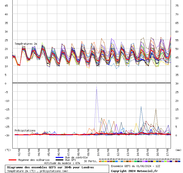
I'm finding it quite difficult to share your pessimism, Brian.  For the south, at least, the predicted very mild temperatures aren't materialising: each run seems to scale it back to just rather mild, with some cooler interludes.


Height of the zero degree isotherm from today's 12z ensemble for London


2m temperature:


Location: South Cambridgeshire
130 metres ASL
52.0N 0.1E


RobN
  • RobN
  • Advanced Member
27 December 2019 20:05:06

Notably low 12Z GEFS cumulative rainfall chart for London


Rob
In the flatlands of South Cambridgeshire 15m ASL.
JACKO4EVER
27 December 2019 20:06:57


I'm finding it quite difficult to share your pessimism, Brian.  For the south, at least, the predicted very mild temperatures aren't materialising: each run seems to scale it back to just rather mild, with some cooler interludes.


Height of the zero degree isotherm from today's 12z ensemble for London


2m temperature:


Originally Posted by: Gandalf The White 


mild, not so mild, very mild, extremely mild, mildly warm...... 


it doesn’t matter because it’s winter and it’s not cold, and shows no signs of being cold, or even about average for any period of time. It’s truly pants, monotonous and predictable in the extreme (not a dig at you, just so bloody frustrating that the heart of winter is being ripped away again).

Remove ads from site

Ads