Remove ads from site

David M Porter
03 December 2014 14:47:59


Indeed we can! My head tells me that we are likely to be stuck in a zonal rut for weeks, but my heart hopes otherwise.


Originally Posted by: Maunder Minimum 


Last winter the zonal rut lasted for two months, the previous winter it only last for 2-3 weeks at the most IIRC. That's how much it can vary from one winter to the next.


Lenzie, Glasgow

"Let us not take ourselves too seriously. None of us has a monopoly on wisdom, and we must always be ready to listen and respect other points of view."- Queen Elizabeth II 1926-2022
JACKO4EVER
03 December 2014 14:57:08
May be a bit of wintryness about next week, especially over night in some spots? Overall though it's not too bad for early winter- all pretty standard fayre if you ask me.
tallyho_83
03 December 2014 17:20:58

I have stayed quiet on the model charts for a week, but looking at the GFS models etc it does look dire for any significant cold or wintry spell - just seasonal more like. The only chance we will see snow will possibly be Sat (Mostly for mountains) and next Wednesday which again will only be restricted to higher ground over Scotland and N England. - Nothing really to write home about but on the positive side at least it's not relentless rain and wind like last year and I guess we still have plenty of time - The winter of 2012/13 only really started from mid January anyway and even then it was never that cold...nothing will compare to December 2010! - When the snow lasted a month in some parts. I never forget driving back from mid Devon (Halberton/Uplowman and Sampford Peverall near Tiverton) on 20th/21st December 2010 and it was around 11:30pm and the temperature was -12c dipped to -13c with freezing fog too and the snow did actually freeze but as I got above the fog over snow covered hills it almost looked day light - winter wonderland ...Moon was so bright and low.


Home Location - Kellands Lane, Okehampton, Devon (200m ASL)
---------------------------------------
Sean Moon
Magical Moon
www.magical-moon.com


Stormchaser
03 December 2014 17:46:26

Sometimes I wonder if December 2010 did more harm than good in terms of raising expectations way too high foot-in-mouth


Anyway, today's GFS 12z op has thrown energy over the block too our east on day 8, which simply speeds up the flattening process that the previous two runs took until day 10 to get going. This happens because the jet is strong enough for the upstream low (which begins off the East U.S. coast in 5 or 6 days time) to develop and attain enough momentum going NE to take the UK trough with it.


ECM's 00z op run treated that low very differently, keeping it weak, phasing it with the UK low, and not managing to get far NE of the UK before running out of steam. That keeps the jet tracking south of the UK, though the push towards the Med. seems to have been downgraded a bit.


For the foreseeable, it looks either stormy and on the cold side, or often unsettled with near average temperatures.


Seems like we're out of luck these days... except perhaps as far as the MJO goes:


ECM's managing to bring a very brief trip to the East Pacific (phases 8-1), where we want it to go. Here's to the trend toward progression further east continuing...


If you have any problems or queries relating to TWO you can Email [email protected]

https://twitter.com/peacockreports 
2023's Homeland Extremes:
T-Max: 30.2°C 9th Sep (...!) | T-Min: -7.1°C 22nd & 23rd Jan | Wettest Day: 25.9mm 2nd Nov | Ice Days: 1 (2nd Dec -1.3°C in freezing fog)
Keep Calm and Forecast On
Solar Cycles
03 December 2014 17:56:12


Sometimes I wonder if December 2010 did more harm than good in terms of raising expectations way too high foot-in-mouth


Anyway, today's GFS 12z op has thrown energy over the block too our east on day 8, which simply speeds up the flattening process that the previous two runs took until day 10 to get going. This happens because the jet is strong enough for the upstream low (which begins off the East U.S. coast in 5 or 6 days time) to develop and attain enough momentum going NE to take the UK trough with it.


ECM's 00z op run treated that low very differently, keeping it weak, phasing it with the UK low, and not managing to get far NE of the UK before running out of steam. That keeps the jet tracking south of the UK, though the push towards the Med. seems to have been downgraded a bit.


For the foreseeable, it looks either stormy and on the cold side, or often unsettled with near average temperatures.


Seems like we're out of luck these days... except perhaps as far as the MJO goes:


ECM's managing to bring a very brief trip to the East Pacific (phases 8-1), where we want it to go. Here's to the trend toward progression further east continuing...


Originally Posted by: Stormchaser 

The ECM was dragging its feet with its MJO projection over the last few days, it now seems to be treading where the UKMO and MOGREPS is which is where we want it for HLB.

Essan
03 December 2014 18:10:41

looking at GFS, Wednesday could see the first proper blizzards of the winter over the Scottish hills


Andy
Evesham, Worcs, Albion - 35m asl
Weather & Earth Science News 

Anyone who is capable of getting themselves made President should on no account be allowed to do the job - DNA
David M Porter
03 December 2014 18:28:04


Sometimes I wonder if December 2010 did more harm than good in terms of raising expectations way too high foot-in-mouth


Originally Posted by: Stormchaser 


IMO it has been a combination of December 2010 plus the events of the previous winter, James. I think that before the end of 2009, people's expectations of the model output in early winter were generally much lower than has been the case since.


Lenzie, Glasgow

"Let us not take ourselves too seriously. None of us has a monopoly on wisdom, and we must always be ready to listen and respect other points of view."- Queen Elizabeth II 1926-2022
Whether Idle
03 December 2014 18:55:58


IMO it has been a combination of December 2010 plus the events of the previous winter, James. I think that before the end of 2009, people's expectations of the model output in early winter were generally much lower than has been the case since.


Originally Posted by: David M Porter 


Back in the 1970s and 1980s the expectation down south was - any snow before Christmas was a real bonus, and the "season" lasted from around December 28th through to the spring equinox.  I feel the same still applies.


12th March 2013 was pretty much the first ice day in 15 years down here.  I think the retained heat in the seas is only going to exacerbate the thermal lag, and help March  regain its position as being a snowier month than December.


Dover, 5m asl. Half a mile from the south coast.
03 December 2014 19:02:53


Back in the 1970s and 1980s the expectation down south was - any snow before Christmas was a real bonus, and the "season" lasted from around December 28th through to the spring equinox.  I feel the same still applies.


12th March 2013 was pretty much the first ice day in 15 years down here.  I think the retained heat in the seas is only going to exacerbate the thermal lag, and help March  regain its position as being a snowier month than December.


Originally Posted by: Whether Idle 


So true Whether idle, Any snow in Dorset pre christmas is very rare.  Then in Dec 2010 I think we got a whole centurys worth of pre christmas snow in one hit. But as both David and James have said I think it has definitely raised expectations.

03 December 2014 19:17:31
Likewise for Chichester...I have no expectations of any snow down these parts until January, if at all...Dec10 was extraordinary and not expecting to see that again in my lifetime...Stormchaser's, you are spot on in your observations!
Brian Gaze
03 December 2014 19:18:36


Back in the 1970s and 1980s the expectation down south was - any snow before Christmas was a real bonus, and the "season" lasted from around December 28th through to the spring equinox.  I feel the same still applies.


12th March 2013 was pretty much the first ice day in 15 years down here.  I think the retained heat in the seas is only going to exacerbate the thermal lag, and help March  regain its position as being a snowier month than December.


Originally Posted by: Whether Idle 


Very true and the same applied in York where I lived. I think in many ways we were lucky in the late 70s and 80s to have a decent number of winters which brought a reasonable amount of snow. Saying that, even then the significant snow events usually only numbered 2 or 3 each year! One of the things which makes me laugh when I read some forecasts is the suggestion that during a cold winter we're going to have numerous snowfalls. In most of lowland Britain that only happens in extreme cases like 47/63. 


Brian Gaze
Berkhamsted
TWO Buzz - get the latest news and views 
"I'm not socialist, I know that. I don't believe in sharing my money." - Gary Numan
Polar Low
03 December 2014 19:20:11

Come on chin up, I could say every winter has been a let down since 62/63 but I dont, anyway slight upgrade on depth of cold later on from ecm


So true Whether idle, Any snow in Dorset pre christmas is very rare.  Then in Dec 2010 I think we got a whole centurys worth of pre christmas snow in one hit. But as both David and James have said I think it has definitely raised expectations.


Originally Posted by: blizzard of 78 

Whether Idle
03 December 2014 19:20:37

Meanwhile in model-land this is the 12z GFS ensembles for London.  A Classic mobile westerly signature  and very reminiscent of the period 1998-2005.  But we all know ensembles can flip especially beyond day 7...


Dover, 5m asl. Half a mile from the south coast.
Polar Low
03 December 2014 19:32:00

Likewise for Chichester...I have no expectations of any snow down these parts until January, if at all...Dec10 was extraordinary and not expecting to see that again in my lifetime...Stormchaser's, you are spot on in your observations!

Originally Posted by: chichesterweatherfan 


Really? how old are you dont give up just yet.

doctormog
03 December 2014 19:48:44


Meanwhile in model-land this is the 12z GFS ensembles for London.  A Classic mobile westerly signature  and very reminiscent of the period 1998-2005.  But we all know ensembles can flip especially beyond day 7...


.


Originally Posted by: Whether Idle 


That looks like a typical unstable polar maritime outlook. Chilly and unsettled at times and very different to the W/SWly "Bartlett High" scenario. Mobile yes, mild no. Not especially wintry but certainly not out of place for the start of the winter season. The ECM 12z op run also supports a similar outlook.


If I was in a NW location (mainly in Scotland) with any elevation I would be expecting to see snow on a few occasions in the coming week to ten days. Elsewhere it will at very least feel like December


Polar Low
03 December 2014 20:15:50

Its a pity in a way you didnt see dec 1981 James, never mind,  but thanks ever so much for the post


Sometimes I wonder if December 2010 did more harm than good in terms of raising expectations way too high foot-in-mouth


Anyway, today's GFS 12z op has thrown energy over the block too our east on day 8, which simply speeds up the flattening process that the previous two runs took until day 10 to get going. This happens because the jet is strong enough for the upstream low (which begins off the East U.S. coast in 5 or 6 days time) to develop and attain enough momentum going NE to take the UK trough with it.


ECM's 00z op run treated that low very differently, keeping it weak, phasing it with the UK low, and not managing to get far NE of the UK before running out of steam. That keeps the jet tracking south of the UK, though the push towards the Med. seems to have been downgraded a bit.


For the foreseeable, it looks either stormy and on the cold side, or often unsettled with near average temperatures.


Seems like we're out of luck these days... except perhaps as far as the MJO goes:


ECM's managing to bring a very brief trip to the East Pacific (phases 8-1), where we want it to go. Here's to the trend toward progression further east continuing...


Originally Posted by: Stormchaser 

Stormchaser
03 December 2014 20:41:53

As you folks are covering the details of the incoming storms very nicely, I'm going to focus this evening on the MJO and what we might see from it's influence.
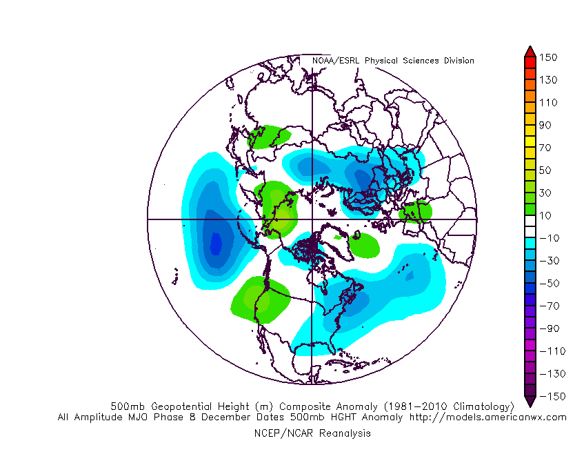


The phase 8 MJO composite bears a lot of resemblance to where GFS ends up at the end of its run. That reflects GFS being bullish with the MJO pushing to the East Pacific.


The final few frames of the run show low heights dropping down west of the Azores, which is the sort of thing needed to allow a ridge around Iceland or Greenland. It always seems to happen right near the end of those GFS runs that head in the right direction. I think the model has been bringing the phase 8 signal through too rapidly and keeps haivng to adjust it back in time. Hopefully not for too much longer!


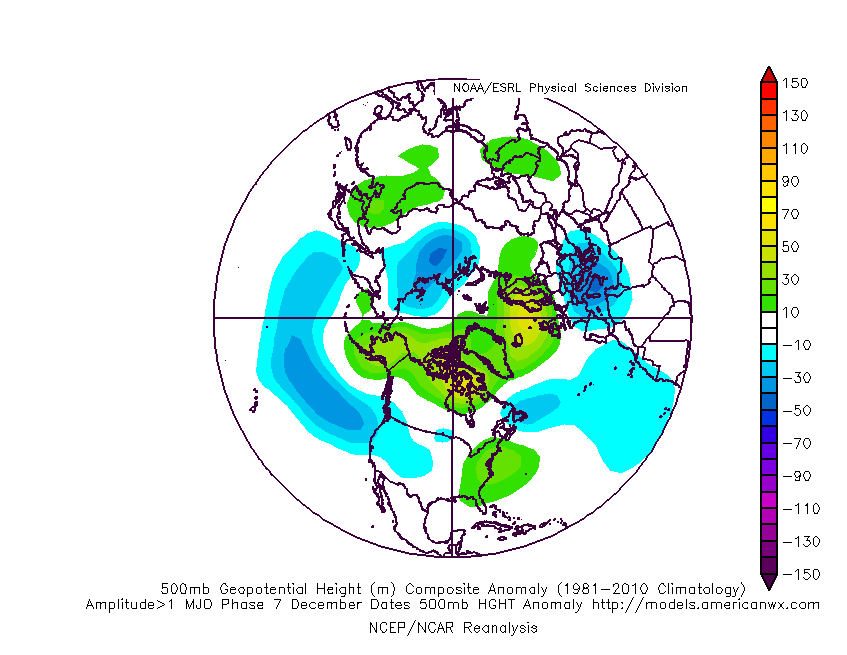
GFS then takes the MJO to phase 1, for which the composite looks like the image below-left:


Clearly that's the real jackpot for encouraging a more substantial rise of heights to our NW.


On the right, I've put the phase 7 composite, as yesterday ECM was showing the MJO grinding to a halt here before subsiding, and I think it goes at least little way toward explaining the few ECM op runs prior to today's 12z effort - with the low heights digging down to the Med. and hints of height rises across Scandinavia.


ECM has since taken the MJO on to phase 8, and although it's fading away by that time, the progression straight through phase 7 does appear to have led ECM to drop any movement towards the phase 7 pattern.


Obviously it's not by any means the whole story, with all manner of other influences out there, but with the MJO in an amplified state, it does tend to have a notable impact and can at times dominate over many other factors.


As a final note, a well informed friend of mine sent me a chart showing what the models predicted about 10 days ago, and all but one of them - including the ECM - showed the MJO fading away or even about-facing and heading back towards Africa. The reality has seen a highly amplified MJO heading quite rapidly eastward.


This seems encouraging for getting the phase 8-1 progression prior to any fading away taking place 


If you have any problems or queries relating to TWO you can Email [email protected]

https://twitter.com/peacockreports 
2023's Homeland Extremes:
T-Max: 30.2°C 9th Sep (...!) | T-Min: -7.1°C 22nd & 23rd Jan | Wettest Day: 25.9mm 2nd Nov | Ice Days: 1 (2nd Dec -1.3°C in freezing fog)
Keep Calm and Forecast On
doctormog
03 December 2014 21:02:11
Yeah, I should have pointed that out PL. The Westenmost parts of Scotland (mainly the Hebrides) look very wet in coming days thanks to slow-moving fronts. They're used to it but it is still pretty wet looking.
GIBBY
03 December 2014 21:22:16

Nothing very Wintry from ECM's 10 Day Mean chart tonight which has moderated barometric pressure across the UK at that time in response to less deep Low pressure further to the North and High to the South. Just plain old wind and rain at times for many by that point with average temperatures for mid December restricting snowfall to high Norther hills. Quite a flat pattern overall.


http://www.wetterzentrale.de/pics/Reem2401.gif


Martin G
Kilmersdon Radstock Bath Somerset


Look up my New Facebook Weather Page  for all the latest up to the minute weather stories as they happen
David M Porter
03 December 2014 21:25:23


As you folks are covering the details of the incoming storms very nicely, I'm going to focus this evening on the MJO and what we might see from it's influence.


The phase 8 MJO composite bears a lot of resemblance to where GFS ends up at the end of its run. That reflects GFS being bullish with the MJO pushing to the East Pacific.


The final few frames of the run show low heights dropping down west of the Azores, which is the sort of thing needed to allow a ridge around Iceland or Greenland. It always seems to happen right near the end of those GFS runs that head in the right direction. I think the model has been bringing the phase 8 signal through too rapidly and keeps haivng to adjust it back in time. Hopefully not for too much longer!


GFS then takes the MJO to phase 1, for which the composite looks like the image below-left:
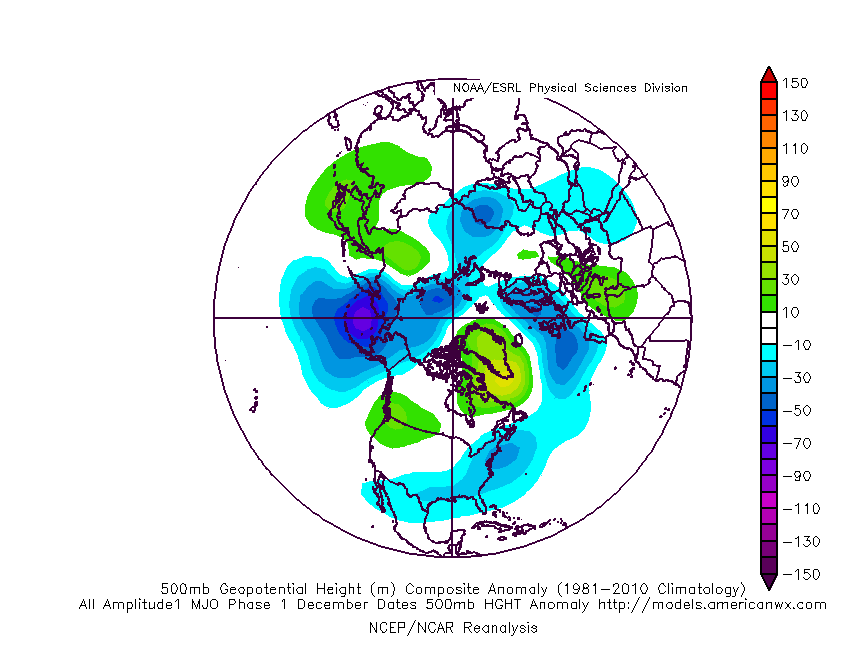


Clearly that's the real jackpot for encouraging a more substantial rise of heights to our NW.


On the right, I've put the phase 7 composite, as yesterday ECM was showing the MJO grinding to a halt here before subsiding, and I think it goes at least little way toward explaining the few ECM op runs prior to today's 12z effort - with the low heights digging down to the Med. and hints of height rises across Scandinavia.


ECM has since taken the MJO on to phase 8, and although it's fading away by that time, the progression straight through phase 7 does appear to have led ECM to drop any movement towards the phase 7 pattern.


Obviously it's not by any means the whole story, with all manner of other influences out there, but with the MJO in an amplified state, it does tend to have a notable impact and can at times dominate over many other factors.


As a final note, a well informed friend of mine sent me a chart showing what the models predicted about 10 days ago, and all but one of them - including the ECM - showed the MJO fading away or even about-facing and heading back towards Africa. The reality has seen a highly amplified MJO heading quite rapidly eastward.


This seems encouraging for getting the phase 8-1 progression prior to any fading away taking place 


Originally Posted by: Stormchaser 


Perhaps some grounds for a bit of optimism then. It seems to me that, generally speaking, we're no worse of in terms of prospects than we were this time last year.


Lenzie, Glasgow

"Let us not take ourselves too seriously. None of us has a monopoly on wisdom, and we must always be ready to listen and respect other points of view."- Queen Elizabeth II 1926-2022
Stormchaser
03 December 2014 21:46:29


Nothing very Wintry from ECM's 10 Day Mean chart tonight which has moderated barometric pressure across the UK at that time in response to less deep Low pressure further to the North and High to the South. Just plain old wind and rain at times for many by that point with average temperatures for mid December restricting snowfall to high Norther hills. Quite a flat pattern overall.


http://www.wetterzentrale.de/pics/Reem2401.gif


Originally Posted by: GIBBY 


For once I can propose an adjustment to your interpretation Martin; it's worth bearing in mind that the spread in positioning of the Atlantic low pressure will nearly always make the mean look flatter than the majority of the individual runs.


Other than that, a fair analysis as usual 


Another thing that's just struck me is that the LTA for December incorporates milder and colder spells, and the milder ones are usually when we have Atlantic westerlies, so in a sense we're looking at a colder than normal spell of Atlantic westerlies...


A classic example of putting a spin on things, an approach often used to make LRFs appear to have verified better than they did 


If you have any problems or queries relating to TWO you can Email [email protected]

https://twitter.com/peacockreports 
2023's Homeland Extremes:
T-Max: 30.2°C 9th Sep (...!) | T-Min: -7.1°C 22nd & 23rd Jan | Wettest Day: 25.9mm 2nd Nov | Ice Days: 1 (2nd Dec -1.3°C in freezing fog)
Keep Calm and Forecast On
Polar Low
03 December 2014 22:27:14

 Can I see the control please.


http://www.knmi.nl/exp/pluim/vijftiendaagse/index.php?run=12


For once I can propose an adjustment to your interpretation Martin; it's worth bearing in mind that the spread in positioning of the Atlantic low pressure will nearly always make the mean look flatter than the majority of the individual runs.


Other than that, a fair analysis as usual 


Another thing that's just struck me is that the LTA for December incorporates milder and colder spells, and the milder ones are usually when we have Atlantic westerlies, so in a sense we're looking at a colder than normal spell of Atlantic westerlies...


A classic example of putting a spin on things, an approach often used to make LRFs appear to have verified better than they did 


Originally Posted by: Stormchaser 

Gooner
03 December 2014 22:42:18

http://modeles.meteociel.fr/modeles/gfs/runs/2014120318/gfsnh-0-372.png?18


The last couple of runs the block to East has appeared, wonder if it will become a player as we go through the month


Remember anything after T120 is really Just For Fun


Marcus
Banbury
North Oxfordshire
378 feet A S L


Russwirral
03 December 2014 22:45:52


http://modeles.meteociel.fr/modeles/gfs/runs/2014120318/gfsnh-0-372.png?18


The last couple of runs the block to East has appeared, wonder if it will become a player as we go through the month


Originally Posted by: Gooner 


aye scandi HP is making another appearance.  What a tease the GFS is!


Remove ads from site

Ads