Remove ads from site

Solar Cycles
01 February 2018 13:01:41


Average daytime maximum temperature v forecast for Saturday:


London        8C  v  3C


Birmingham  6C  v  4C


Manchester   7C  v  3C


Originally Posted by: Gandalf The White 

Indeed, I think Ian is being a bit mischievous there. Of course the projected temps may well be wrong but going of the current data temps will be several degrees below the monthly average.

Rob K
01 February 2018 13:14:58


We are facing probably our best prospect of widespread wintry weather in years... with the chances of snow on snow events for quite a wide area of the country.  Theres a real chance that this Cold air could lock in and be topped up.  


The GEFS are probably the lowest ive seen them - on a grouped scale - for the extended period that they are.


A word of caution- that we know how fickle our weather is, I hate to ramp.  But you cant deny the below is simple brilliant.
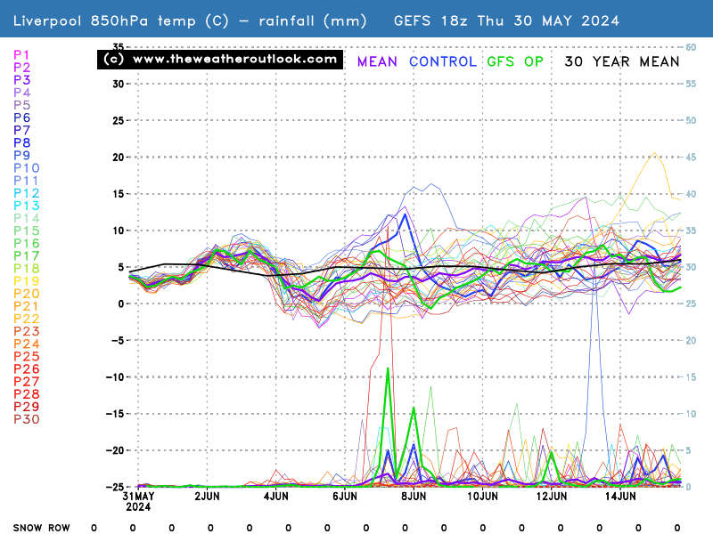


No chart available for the selected hour. Many charts start at 3 hours ahead, so if you have 0 hours selected try stepping forward or selecting a later hour.


Originally Posted by: Russwirral 


This was posted when it was still the 00Z ensemble, but they still look pretty good. The 850s have crept up a tad for Saturday, hopefully they won't do the same for Tuesday.


Still plenty of cold runs right out to the end, too. Run 5 would be  a nice one.


Yateley, NE Hampshire, 73m asl
"But who wants to be foretold the weather? It is bad enough when it comes, without our having the misery of knowing about it beforehand." — Jerome K. Jerome
Stolen Snowman
01 February 2018 13:19:30


Such a shame. Winter is over.  


Originally Posted by: Gusty 


I’ve been away for a while.... and have just returned from cleaning the deckchairs after reading this (and other similar posts).


Has something changed? 


Something must be afoot as Tally has stopped using the frustrated red face man emoticon...(!).


Seriously though,the 1985 re-run is still on table which is good news for cold lovers.


Recently it’s been a bit like reading the forum for my local football club on here! A bit painful to watch at times. Retron’s reasoned and considered analysis is pure class though.


Statistics prove that the period just after records began witnessed some of the most extreme weather ever recorded. Records were being broken on a frequency that has not been repeated since.
Posting live from a pub somewhere in Burton upon Trent
Sasa
  • Sasa
  • Advanced Member
01 February 2018 13:34:21
BBC weather forecast at 13.30 just confirm snow risk for Tuesday of next week. This is the first time I have seen this.
Kingston Upon Thames
Gandalf The White
01 February 2018 13:35:40


Indeed, I think Ian is being a bit mischievous there. Of course the projected temps may well be wrong but going of the current data temps will be several degrees below the monthly average.


Originally Posted by: Solar Cycles 


Only a bit?


I had a word starting with 't' in mind, rather than 'm'.


Location: South Cambridgeshire
130 metres ASL
52.0N 0.1E


Gavin D
01 February 2018 13:39:13


Thats a bold statement, when not one run in the GEFS ens goes anywhere near the 30 year average (850 temps) until ~ 7th Feb:


https://www.theweatheroutlook.com/twodata/chart.aspx?chart=/charts/gefs/gefsens850london0.png?cb=801


Originally Posted by: hobensotwo 


Seems fair to me bbc weather lastnight stated cold rain for many on Saturday with snow over the likes of the pennines

Brian Gaze
01 February 2018 13:39:21

BBC weather forecast at 13.30 just confirm snow risk for Tuesday of next week. This is the first time I have seen this.

Originally Posted by: Sasa 


I'm more interested in the possibilities this Saturday because it is nearer.


Brian Gaze
Berkhamsted
TWO Buzz - get the latest news and views 
"I'm not socialist, I know that. I don't believe in sharing my money." - Gary Numan
Tim A
01 February 2018 13:45:19
Saturday looks very marginal, think it will require some heavy precipitation arriving at the right time to turn places white. Otherwise could be 2-3c with light rain and sleet. The model output I have seen support these type of temperatures rather than the 0 -1C you would ideally like.
Tim
NW Leeds
187m asl

 My PWS 
Gandalf The White
01 February 2018 13:45:35

BBC weather forecast at 13.30 just confirm snow risk for Tuesday of next week. This is the first time I have seen this.

Originally Posted by: Sasa 


It has the potential to be a classic snow event, with an occluded trough moving into a very cold continental airmass, with cold Pm air following behind. What we don't want is for the trough to stall too far west or weaken too much.  Nirvana would be for it to stall somewhere over the eastern half (IMBY).


Location: South Cambridgeshire
130 metres ASL
52.0N 0.1E


Brian Gaze
01 February 2018 13:47:11

Saturday looks very marginal, think it will require some heavy precipitation arriving at the right time to turn places white. Otherwise could be 2-3c with light rain and sleet. The model output I have seen support these type of temperatures rather than the 0 -1C you would ideally like.

Originally Posted by: Tim A 


Absolutely but a bird in the hand is worth three in the bush (adapted for UK snow). 


Brian Gaze
Berkhamsted
TWO Buzz - get the latest news and views 
"I'm not socialist, I know that. I don't believe in sharing my money." - Gary Numan
Jeff
  • Jeff
  • Advanced Member
01 February 2018 13:49:52
Dear all, I wish I had more time to post in this forum as I find it so interesting, but, I couldn’t resist the following observation.

After the various models took a bit of stick in recent weeks, take a look at comments made by several posters in pages 2 and 3 of this thread (23rd Jan - the Met Office Fire) and review comments made about what the models were showing (ECM at 10 days) and some of the GFS suite at 10 days plus. Now take a look at the 1-5 day output and draw your own conclusions on model capability to estimate (roughly) the synoptic set up between 1 and 2 weeks away when we focus on trends in sequential runs, and the GFS suite, not single GFS Op runs.

Jeff
On the East/West Sussex Border
70m ASL
Bertwhistle
01 February 2018 13:51:05


Only a bit?


I had a word starting with 't' in mind, rather than 'm'.


Originally Posted by: Gandalf The White 


Me too; but I think you might all have Billy Goat Gruffed him back over the bridge for now.


Bertie, Itchen Valley.
Retire while you can still press the 'retire now' button.
Sasa
  • Sasa
  • Advanced Member
01 February 2018 13:51:52


I'm more interested in the possibilities this Saturday because it is nearer.


Originally Posted by: Brian Gaze 


Brian, From memory they had 7 or perhaps 8 degrees on Saturday and 6c for Monday. I think they are wrong. We have 7c today so if the trend is one of getting colder as they say surely 1c is nothing note worthy.


I am speaking about the SE of course.


Kingston Upon Thames
Gandalf The White
01 February 2018 13:52:05


Seems fair to me bbc weather lastnight stated cold rain for many on Saturday with snow over the likes of the pennines


Originally Posted by: Gavin D 


Did the BBC weather say we'd have average temperatures?  That's not what I heard or saw on the charts.


Location: South Cambridgeshire
130 metres ASL
52.0N 0.1E


Gandalf The White
01 February 2018 13:53:19

Dear all, I wish I had more time to post in this forum as I find it so interesting, but, I couldn’t resist the following observation.

After the various models took a bit of stick in recent weeks, take a look at comments made by several posters in pages 2 and 3 of this thread (23rd Jan - the Met Office Fire) and review comments made about what the models were showing (ECM at 10 days) and some of the GFS suite at 10 days plus. Now take a look at the 1-5 day output and draw your own conclusions on model capability to estimate (roughly) the synoptic set up between 1 and 2 weeks away when we focus on trends in sequential runs, and the GFS suite, not single GFS Op runs.

Jeff

Originally Posted by: Jeff 


Very succinct and spot on.


Location: South Cambridgeshire
130 metres ASL
52.0N 0.1E


Sasa
  • Sasa
  • Advanced Member
01 February 2018 13:55:00


It has the potential to be a classic snow event, with an occluded trough moving into a very cold continental airmass, with cold Pm air following behind. What we don't want is for the trough to stall too far west or weaken too much.  Nirvana would be for it to stall somewhere over the eastern half (IMBY).


Originally Posted by: Gandalf The White 


Agree the extent of the snow penetrating eastwards is a ? mark. Too far out to call accurately at this stage and probably best left to the day before.


Kingston Upon Thames
Hippydave
01 February 2018 13:56:10

Be interesting to see how the GFS does at handling the trough disruption during the upcoming setup - a few years ago it was woeful and kept collapsing the pattern and introducing mild air, which never came.


It doesn't seem to be doing that this time and the 6z ens are, a blip aside chilly or cold throughout with the mean never getting warmer than -2/-3 at 850 level


Whether my daughter gets to use the sledge we bought her 2-3 years ago is debateable but it's looking more likely than the last few winters


Home: Tunbridge Wells
Work: Tonbridge
Brian Gaze
01 February 2018 13:56:25


Brian, From memory they had 7 or perhaps 8 degrees on Saturday and 6c for Monday. I think they are wrong. We have 7c today so if the trend is one of getting colder as they say surely 1c is nothing note worthy.


I am speaking about the SE of course.


Originally Posted by: Sasa 


BBC? I don't know who provides their forecasts now. What I know is the Met Office weather warnings / snow forecasts in recent weeks have certainly seemed flaky at times and below their usual high standards. This Sat could well be a rain event for most but I continue to think it is worth watching closely.


Brian Gaze
Berkhamsted
TWO Buzz - get the latest news and views 
"I'm not socialist, I know that. I don't believe in sharing my money." - Gary Numan
Bertwhistle
01 February 2018 13:57:50

Dear all, I wish I had more time to post in this forum as I find it so interesting, but, I couldn’t resist the following observation.

After the various models took a bit of stick in recent weeks, take a look at comments made by several posters in pages 2 and 3 of this thread (23rd Jan - the Met Office Fire) and review comments made about what the models were showing (ECM at 10 days) and some of the GFS suite at 10 days plus. Now take a look at the 1-5 day output and draw your own conclusions on model capability to estimate (roughly) the synoptic set up between 1 and 2 weeks away when we focus on trends in sequential runs, and the GFS suite, not single GFS Op runs.

Jeff

Originally Posted by: Jeff 


Good point made Jeff; in fact, look back at the opening post from Brian, and its associated snow row. Who'd have thought we'd see the numbers we do now? This is just one small example, of course, that backs up your point.


Bertie, Itchen Valley.
Retire while you can still press the 'retire now' button.
bledur
01 February 2018 14:01:43


BBC? I don't know who provides their forecasts now. What I know is the Met Office weather warnings / snow forecasts in recent weeks have certainly seemed flaky at times and below their usual high standards. This Sat could well be a rain event for most but I continue to think it is worth watching closely.


Originally Posted by: Brian Gaze 


Met Office are supplying data for BBC forecasts till March 2018. Quite possibly longer if Meteogroup are still not ready.

Rob K
01 February 2018 14:14:33


Brian, From memory they had 7 or perhaps 8 degrees on Saturday and 6c for Monday. I think they are wrong. We have 7c today so if the trend is one of getting colder as they say surely 1c is nothing note worthy.


I am speaking about the SE of course.


Originally Posted by: Sasa 


Raw output for the SE suggests about 4C on Saturday (5C in London) and 3C on Monday (4C in London).


The same raw output that feeds the Weather Channel app suggests a mean temperature next week (Mon to Fri) at or below zero here, with highs of between 2C and 3C and lows between -2C and -4C.


Yateley, NE Hampshire, 73m asl
"But who wants to be foretold the weather? It is bad enough when it comes, without our having the misery of knowing about it beforehand." — Jerome K. Jerome
Rob K
01 February 2018 14:17:44


Plenty of interest going forward. Here's a static snapshot of the GEFS12z.


Originally Posted by: Brian Gaze 


Following on from Bertwistle's post, here's that ensemble from the first page. The control run from Feb 1st on that chart is actually uncannily similar to the shape of the current ensemble mean, just a few hours early with the cold plunge 


Yateley, NE Hampshire, 73m asl
"But who wants to be foretold the weather? It is bad enough when it comes, without our having the misery of knowing about it beforehand." — Jerome K. Jerome
Sasa
  • Sasa
  • Advanced Member
01 February 2018 14:19:12


Raw output for the SE suggests about 4C on Saturday (5C in London) and 3C on Monday (4C in London).


The same raw output that feeds the Weather Channel app suggests a mean temperature next week (Mon to Fri) at or below zero here, with highs of between 2C and 3C and lows between -2C and -4C.


Originally Posted by: Rob K 


Brian,


Correct it was the BBC forecast. I have no idea why you would mention that it will be getting colder and then present temperatures which are same or 1 degree higher then what we have today. It really confuses me and annoys me as well.


Ever since they invested in that 100m computer their forecasts have got worse as far as I am concerned.


Kingston Upon Thames
Brian Gaze
01 February 2018 14:23:39


Brian,


Correct it was the BBC forecast. I have no idea why you would mention that it will be getting colder and then present temperatures which are same or 1 degree higher then what we have today. It really confuses me and annoys me as well.


Ever since they invested in that 100m computer their forecasts have got worse as far as I am concerned.


Originally Posted by: Sasa 


Here are the DWD ICON 6z max (like GFS they provide max and min temps for each timestep) temps for Sat.


Wrt Beeb forecasts my bone of contention is their propensity to zoom in on shower activity. It is farcical IMO and they would be better off going back to shower icons over areas rather than displaying raw model output.


Brian Gaze
Berkhamsted
TWO Buzz - get the latest news and views 
"I'm not socialist, I know that. I don't believe in sharing my money." - Gary Numan
Chiltern Blizzard
01 February 2018 14:32:53


Here are the DWD ICON 6z max (like GFS they provide max and min temps for each timestep) temps for Sat.


Wrt Beeb forecasts my bone of contention is their propensity to zoom in on shower activity. It is farcical IMO and they would be better off going back to shower icons over areas rather than displaying raw model output.


Originally Posted by: Brian Gaze 


Looks good for Buxton and similar places along the Pennine/Peak District spine but cold sleet or rain for others. Time for upgrades though.


iPhone


Rendlesham, Suffolk 20m asl

Remove ads from site

Ads