Remove ads from site

doctormog
04 January 2020 10:19:37
I think most notably in terms of statistics it will be the temperatures on Tuesday in areas with a Föhn effect but in terms of perception and logistical considerations it will be the wind (especially in the northern parts) at times.
tallyho_83
04 January 2020 11:12:26


Trying to see something cold and wintry potential in the 18z ensembles:


Growing support for an easterly just after mid month around 16th but still a long way off and it's JFF. But of some interest at least for now.


P2


P4


P19


P20


Originally Posted by: tallyho_83 


Re both the 00 and 06z GFS


That glimmer of hope for a colder spell around 16th has now been dashed!


Instead of the HP building further north it appears that the HP will build up from the south and we could end up really mild towards end of the run especially as southerly winds take a hold - this is a perfect summer chart.


Home Location - Kellands Lane, Okehampton, Devon (200m ASL)
---------------------------------------
Sean Moon
Magical Moon
www.magical-moon.com


tallyho_83
04 January 2020 11:28:09

The Place to be for cold Doc with Yellowknife and much of northern Canada some 10c or so below average at 850hpa and on surface? - flying back there anytime soon?


Home Location - Kellands Lane, Okehampton, Devon (200m ASL)
---------------------------------------
Sean Moon
Magical Moon
www.magical-moon.com


Sevendust
04 January 2020 11:29:07

If you're looking for cold then probably come back and review in a weeks time in the hope of changes.


The 0z ensembles are almost without interest in that regard.

DPower
04 January 2020 11:52:16

For the life of me can not see why some posters here and on other forums were or are feeling optimistic at charts post t240. There is talk of the next MJO wave moving through phases 7,8 and 1 and helping to induce a bottom up (troposphere led) warming and possible splitting of the upper trop vortex but at the range being shown it just looks like noise to me. It appears on one run and then dropped on the next. 


A lot of this positivity being placed on the relaxation of the strong positive IOD phase that we have seen since early Autumn. Myself I think it will be the turn of the month at the earliest before we may possibly see anything wintry of note in the UK.

Ally Pally Snowman
04 January 2020 12:11:20

The lack of eye candy cold charts this winter is extraordinary.  Literally nothing for the Coldies to get excited about never seen anything like it in my 10 or so years looking at charts. Looks like next week will smash some more warm records so as others have said might aswell embrace the mildness.


Bishop's Stortford 85m ASL.
briggsy6
04 January 2020 12:19:10

It's best always to try and turn a negative into a positive. Therefore be happy you won't have to risk slipping on sheet ice or having to sweep your front drive. Also saves on heating bills.


Location: Uxbridge
Joe Bloggs
04 January 2020 12:22:04


It's best always to try and turn a negative into a positive. Therefore be happy you won't have to risk slipping on sheet ice or having to sweep your front drive. Also saves on heating bills.


Originally Posted by: briggsy6 


People say this about heating bills, which I don’t understand.


It would have to get pretty warm in winter, say 15C plus, for us not to have the heating on. Maybe it’s just me in this old terraced house! 


Manchester City Centre, 31m ASL

Caz
  • Caz
  • Advanced Member
04 January 2020 12:40:15


The lack of eye candy cold charts this winter is extraordinary.  Literally nothing for the Coldies to get excited about never seen anything like it in my 10 or so years looking at charts. Looks like next week will smash some more warm records so as others have said might aswell embrace the mildness.


Originally Posted by: Ally Pally Snowman 

The lack of eye candy charts is the lesser of two evils!  There’s nothing worse than getting excited by eye candy charts, then getting disappointed when they materialise into crap weather!  I’d rather not be teased!


Market Warsop, North Nottinghamshire.
Join the fun and banter of the monthly CET competition.
fairweather
04 January 2020 13:07:24


People say this about heating bills, which I don’t understand.


It would have to get pretty warm in winter, say 15C plus, for us not to have the heating on. Maybe it’s just me in this old terraced house! 


Originally Posted by: Joe Bloggs 


Presumably you have a thermostat. So the amount of energy required will be much less to heat rooms from 15C to 21C than from 5C outside so you should save a fair bit. 


S.Essex, 42m ASL
moomin75
04 January 2020 13:11:56


The lack of eye candy cold charts this winter is extraordinary.  Literally nothing for the Coldies to get excited about never seen anything like it in my 10 or so years looking at charts. Looks like next week will smash some more warm records so as others have said might aswell embrace the mildness.


Originally Posted by: Ally Pally Snowman 

Because this sort of pattern is easier for the models to handle, and has been pretty much consistent bar the occasional rogue run for several weeks.


There is no end in sight, and I really do think that we are running out of time. At the very least we have at least 10-14 more days of this pattern, that takes us close to February.


And I just can't see a way out of this pattern and winter is just not coming this year, until northern blocking no doubt returns in time for spring.


Witney, Oxfordshire
100m ASL
Joe Bloggs
04 January 2020 13:23:27


Presumably you have a thermostat. So the amount of energy required will be much less to heat rooms from 15C to 21C than from 5C outside so you should save a fair bit. 


Originally Posted by: fairweather 


We have a thermostat in the dining room set to 23C , but I don’t think I’ve ever known it to reach that temperature and knock the heating off. :O


Like I said, old terraced house. Don’t get me wrong, we can physically turn the heating off when it’s very mild but we probably wouldn’t do so unless the outside temp reached 15C. Probably for another thread. :D 


Manchester City Centre, 31m ASL

Brian Gaze
04 January 2020 13:40:55

In the Met Office article Retron linked recently it says, "[December] was 1.3 °C warmer than average with a mean temperature for the UK of 5.1 °C." I realise that isn't record breaking but it is a substantial anomaly. The medium range models are continuing to suggest milder than average conditions for much of the next 2 or 3 weeks and at times it could be very mild. Therefore, I stand by my suggestion that we could be living through a winter that will go on to be remembered as an all time classic. It could even snuggle up alongside those mild late 80s efforts. 


Brian Gaze
Berkhamsted
TWO Buzz - get the latest news and views 
"I'm not socialist, I know that. I don't believe in sharing my money." - Gary Numan
tallyho_83
04 January 2020 13:49:13


In the Met Office article Retron linked recently it says, "[December] was 1.3 °C warmer than average with a mean temperature for the UK of 5.1 °C." I realise that isn't record breaking but it is a substantial anomaly. The medium range models are continuing to suggest milder than average conditions for much of the next 2 or 3 weeks and at times it could be very mild. Therefore, I stand by my suggestion that we could be living through a winter that will go on to be remembered as an all time classic. It could even snuggle up alongside those mild late 80s efforts. 


Originally Posted by: Brian Gaze 


Well your forecast looks right then and others wrong. However your December forecast of close to average was incorrect. So Brian? What would you think is the cause of such mild weather and continuous mild? Do you think it's purely down to the SST's in Atlantic and Pacific or down to the extreme cold temps in the STRATOSPHERE which has really strengthened the polar Vortex?


Home Location - Kellands Lane, Okehampton, Devon (200m ASL)
---------------------------------------
Sean Moon
Magical Moon
www.magical-moon.com


Gavin P
04 January 2020 13:50:20

I'm already starting to think about the possibility of the 114 year old January 1916 CET record going out the window this month! 


You have to say that record has done well to survive so long but can it hold on for January 2020?


Rural West Northants 120m asl
Short, medium and long range weather forecast videos @ https://www.youtube.com/user/GavsWeatherVids
Brian Gaze
04 January 2020 14:25:56


Well your forecast looks right then and others wrong. However your December forecast of close to average was incorrect. So Brian? What would you think is the cause of such mild weather and continuous mild? Do you think it's purely down to the SST's in Atlantic and Pacific or down to the extreme cold temps in the STRATOSPHERE which has really strengthened the polar Vortex?


Originally Posted by: tallyho_83 


I could Google a few big words and write a flowery response but I won't. It would imply that I know the real reason. If I or anyone else did they would be producing consistently accurate seasonal forecasts. All that can be said with any validity is:


1) Cold winters tend to come in clusters. This and basic probability suggest that those people who think a "cold winter is overdue because the last couple were mild" are talking nonsense.


2) Background warming (regardless of cause it is farcical to deny it has taken place) means the likelihood is the bullseye for the UK has smallened in recent decades


Brian Gaze
Berkhamsted
TWO Buzz - get the latest news and views 
"I'm not socialist, I know that. I don't believe in sharing my money." - Gary Numan
tallyho_83
04 January 2020 14:33:42


I could Google a few big words and write a flowery response but I won't. It would imply that I know the real reason. If I or anyone else did they would be producing consistently accurate seasonal forecasts. All that can be said with any validity is:


1) Cold winters tend to come in clusters. This and basic probability suggest that those people who think a "cold winter is overdue because the last couple were mild" is talking nonsense.


2) Background warming (regardless of cause it is farcical to deny it has taken place) means the likelihood is the bullseye for the UK has smallened in recent decades


Originally Posted by: Brian Gaze 


Yes clusters like early 90's 1990/91 being a memorable one and early 2000's like 2002/03 and 03/04 and then 04/05 esp in Feb 05, and 08/09, 09/10 and first part of winter 10/11, however past several winters the PV has been so strong along with really cold temps in stratosphere so I wonder - regardless of us being in solar minimum to increase blocking chances - the PV and it's strength is the main factor really!?


So the point I am making here is that we could be in a weak La Nina or easterly QBO and despite this if the Polar Vortex is strong and zonal winds are exceptionally positive then this is really curtains for a colder winter despite solar minimum and whatever the SST's are in the Pacific/Atlantic and whatever the QBO is? As in the Polar Votex and it's strength over rules it all regardless!?


The only way out of this is a SSW but this looks highly unlikely and as we know from last years experience it failed to deliver proper HLB.


Home Location - Kellands Lane, Okehampton, Devon (200m ASL)
---------------------------------------
Sean Moon
Magical Moon
www.magical-moon.com


johncs2016
04 January 2020 14:56:33

For anyone looking for some cold weather during this winter, these charts for the AO and NAO are probably not what you want to be seeing as together, they appear to point towards a continued mild outlook with little or no prospect of any cold weather here.
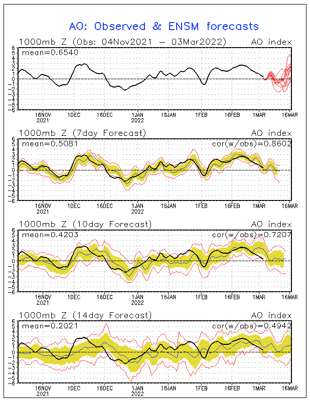


As you can see above, the AO looks set to remain positive and if anything, become even more positive once we get to around the second week of this month with even more cold air being trapped in the Arctic region instead of coming into the mid-latitude regions.
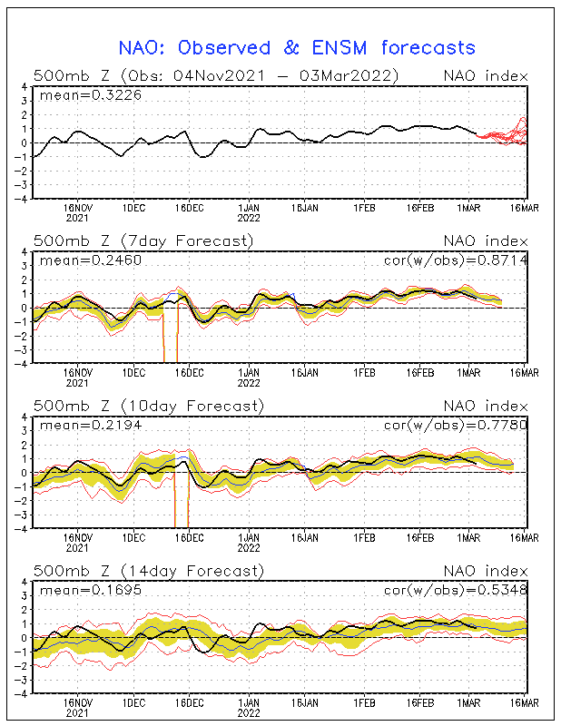


Meanwhile, the above chart for the NAO doesn't look quite so alarming, but it still shows the NAO remaining positive as a result of us remaining in a more zonal pattern of weather under a strong polar vortex. Furthermore, this also goes against Gavin P.'s earlier forecast for a weakly negative NAO during this winter, which he gave out during last summer.


The north of Edinburgh, usually always missing out on snow events which occur not just within the rest of Scotland or the UK, but also within the rest of Edinburgh.
Ally Pally Snowman
04 January 2020 15:02:35


Because this sort of pattern is easier for the models to handle, and has been pretty much consistent bar the occasional rogue run for several weeks.


There is no end in sight, and I really do think that we are running out of time. At the very least we have at least 10-14 more days of this pattern, that takes us close to February.


And I just can't see a way out of this pattern and winter is just not coming this year, until northern blocking no doubt returns in time for spring.


Originally Posted by: moomin75 


Have to say  I completely agree with you, I would be staggered if we get a decent cold spell this winter. Definitely has that 88/89 feel about it but with added 30 years of GW.


Bishop's Stortford 85m ASL.
JACKO4EVER
04 January 2020 17:27:24


Well your forecast looks right then and others wrong. However your December forecast of close to average was incorrect. So Brian? What would you think is the cause of such mild weather and continuous mild? Do you think it's purely down to the SST's in Atlantic and Pacific or down to the extreme cold temps in the STRATOSPHERE which has really strengthened the polar Vortex?


Originally Posted by: tallyho_83 


tally, I’m struggling to find your long range winter forecast 2019-20. Can you refresh my memory please ?? 😉

doctormog
04 January 2020 17:34:48
Yes, definitely running out of time...

[looks at calendar and shakes head]

Anyway back to the models and Tuesday still has that spike of super mild air followed by t850s 15°C lower here 24 hours later. That in itself is quite remarkable.

If it stays dry I would hazard a guess of 17°C on the Moray Firth of Tuesday. With sub528 dam air on Wednesday it will feel a bit colder I would guess! Still little if any sign of prolonged cold or wintry weather though.
JACKO4EVER
04 January 2020 17:51:06

Yes, definitely running out of time...

[looks at calendar and shakes head]

Anyway back to the models and Tuesday still has that spike of super mild air followed by t850s 15°C lower here 24 hours later. That in itself is quite remarkable.

If it stays dry I would hazard a guess of 17°C on the Moray Firth of Tuesday. With sub528 dam air on Wednesday it will feel a bit colder I would guess! Still little if any sign of prolonged cold or wintry weather though.

Originally Posted by: doctormog 


I think we need to look further upstream Doc, see what’s happening US and Pacific side for any prospects of winter proper. I’m actually going for 18c on Tuesday, but realise that’s a hopecast rather than any solid forecast. 

Gandalf The White
04 January 2020 17:54:15


For anyone looking for some cold weather during this winter, these charts for the AO and NAO are probably not what you want to be seeing as together, they appear to point towards a continued mild outlook with little or no prospect of any cold weather here.


As you can see above, the AO looks set to remain positive and if anything, become even more positive once we get to around the second week of this month with even more cold air being trapped in the Arctic region instead of coming into the mid-latitude regions.


Meanwhile, the above chart for the NAO doesn't look quite so alarming, but it still shows the NAO remaining positive as a result of us remaining in a more zonal pattern of weather under a strong polar vortex. Furthermore, this also goes against Gavin P.'s earlier forecast for a weakly negative NAO during this winter, which he gave out during last summer.


Originally Posted by: johncs2016 


As I understand it those charts are derived from the model output, not an independent dataset.


Location: South Cambridgeshire
130 metres ASL
52.0N 0.1E


doctormog
04 January 2020 18:02:39


As I understand it those charts are derived from the model output, not an independent dataset.


Originally Posted by: Gandalf The White 


Yes, I think they are derived from the GFS (MRF) data.


Remove ads from site

Ads