Remove ads from site

Gandalf The White
08 January 2020 17:21:35

Another GFS op run hinting at a sign of change in the mid to longer term, albeit nothing too exciting. Perhaps early signs of a pattern change?

Originally Posted by: doctormog 


Yes, I've been thinking that for the last few runs.  What we might get instead is still problematic but as the latter reaches of the GFS 12z show it only takes a day or two to shuffle the pieces on the board and deliver something quite different to the unrelenting zonality.


If there is a pattern change does that mean, as predicted by some, that winter is over?


Location: South Cambridgeshire
130 metres ASL
52.0N 0.1E


Gandalf The White
08 January 2020 18:45:25

Still a very strong signal for a significant rise in pressure from later next week

http://modeles7.meteociel.fr/modeles/gens/graphe_ens4.php?x=&y=&ext=1&run=12&ville=Londres&lat=51.5085&lon=-0.12574&runpara=0


The mean climbs over 30mb but the Op increases by almost double that (58mb from trough to peak)


Location: South Cambridgeshire
130 metres ASL
52.0N 0.1E


doctormog
08 January 2020 18:53:02


Still a very strong signal for a significant rise in pressure from later next week

http://modeles7.meteociel.fr/modeles/gens/graphe_ens4.php?x=&y=&ext=1&run=12&ville=Londres&lat=51.5085&lon=-0.12574&runpara=0


The mean climbs over 30mb but the Op increases by almost double that (58mb from trough to peak)


Originally Posted by: Gandalf The White 


The increase in the op run here is about 75mb or more. 


http://www.meteociel.fr/cartes_obs/gens_display.php?x=&y=&run=12&lat=57.2&lon=-2.3&runpara=0&type=1&ext=1 


Arcus
08 January 2020 19:10:02

...and GFS finally looking at Phase 7 MJO in 2 weeks time! Woooo! High latitude blocking guaranteed!


Probably...


...possibly....


Ben,
Nr. Easingwold, North Yorkshire
30m asl
ballamar
08 January 2020 19:10:46


Is that via the Pacific, Asia and Europe or Canada and the Atlantic?


Originally Posted by: fairweather 


i would say none just a tale I heard one wondered if anyone else.

Gandalf The White
08 January 2020 19:27:58


The increase in the op run here is about 75mb or more. 


http://www.meteociel.fr/cartes_obs/gens_display.php?x=&y=&run=12&lat=57.2&lon=-2.3&runpara=0&type=1&ext=1 


Originally Posted by: doctormog 


Sorry, I tend to use London. I should realise there are other cities.....


Not unusually, ECM isn't buying the pressure rise at all - at least not in the Op run.


Location: South Cambridgeshire
130 metres ASL
52.0N 0.1E


doctormog
08 January 2020 19:50:52


Sorry, I tend to use London. I should realise there are other cities.....


Not unusually, ECM isn't buying the pressure rise at all - at least not in the Op run.


Originally Posted by: Gandalf The White 


No worries I wasn’t complaining, I was just pointing out that it is even more extreme up here in terms of an increase.


I wonder if the ECM op run was hinting at a change on the day 10 chart. Although of course all the usual caveats of a single op run and at day 10 applies! It may be worth a peek at the extended ensemble data and of course subsequent runs (at day 9/10). 


Hippydave
08 January 2020 19:59:20

Well the GFS run might make it even harder to achieve that top 10 mildest winter place (), although as GTW has mentioned the ECM Op at least isn't buying the HP build which helps to cool things down on the GFS. Both models though do have cooler air than recently although again GFS keener to bring colder air over the country than the ECM. In the near to mid term neither is anything exciting temp wise, both are unsettled with the potential for some stormy conditions at times.


The GFS ens did sniff out a similar HP build before Xmas (as judging by the MetO online forecast did their models) although sadly the Atlantic was too strong at that stage and shunted it all south with only a couple of days of  proper inversion conditions and a lot of gloomy weather afterwards (down here at least anyway).


Hopefully this time round the HP can build further North and won't just get shoved aside, which would also help to get some cold air building in to Europe as shown on the (I know it won't happen as shown) T384 chart.


Home: Tunbridge Wells
Work: Tonbridge
jhall
08 January 2020 20:13:25


i would say none just a tale I heard one wondered if anyone else.


Originally Posted by: ballamar 


I heard it, I think from my father. But it was three weeks from the eastern US in the version I heard. What took it so long? wink It's all nonsense, of course.


Cranleigh, Surrey
Gandalf The White
08 January 2020 20:23:07


I heard it, I think from my father. But it was three weeks from the eastern US in the version I heard. What took it so long? wink It's all nonsense, of course.


Originally Posted by: jhall 


I always thought there was a hint of logic in that belief: eastern seaboard trough; mid-Atlantic ridge; trough around Scandinavia.  Lots of other options, of course.


Location: South Cambridgeshire
130 metres ASL
52.0N 0.1E


White Meadows
08 January 2020 20:26:29
Remarkable (or unremarkable) to see that model performance remained totally normal/ good over Christmas. I’m still waiting for delayed data to change the verification on this graph but it doesn’t seem to change with each update:

https://www.emc.ncep.noaa.gov/gmb/STATS/html/new_acz6.html 
Gusty
08 January 2020 21:07:12

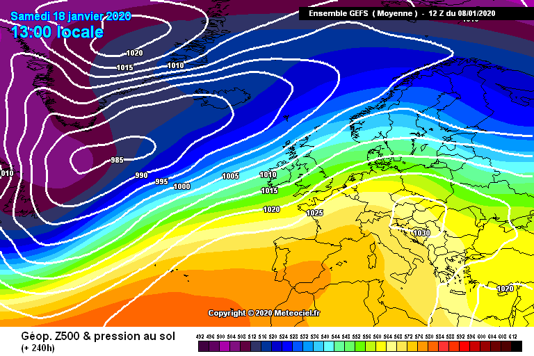
Check out the GEFS mean at 168 hours !


Rock solid strong zonal agreement. All 20 perts are virtually identical.
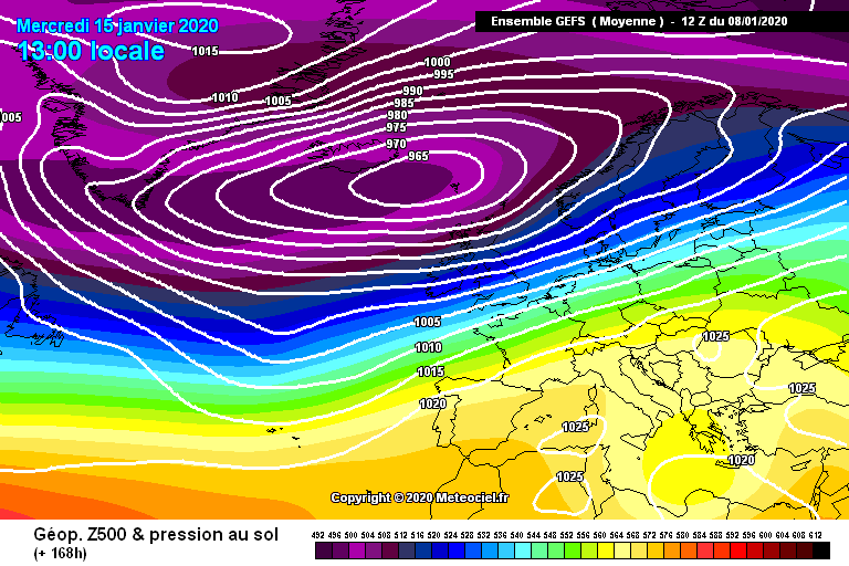


By 240 hours the mean becomes less reliable naturally but there is a weakish signal to build pressure from the south. Its worth mentioning that there are a fair few unsettled options remaining at that stage so confidence for a transition to something a little more settled has to be relatively low.


Steve - Folkestone, Kent
Current conditions from my Davis Vantage Vue
https://www.wunderground.com/dashboard/pws/IFOLKE11 
Join Kent Weather on Facebook.
https://www.facebook.com/stevewall69/ 


doctormog
08 January 2020 21:09:22
Yes, any sign of a pattern change is indeed beyond day 7 with the tentative signs at day 10 or beyond.
DPower
08 January 2020 21:48:52


...and GFS finally looking at Phase 7 MJO in 2 weeks time! Woooo! High latitude blocking guaranteed!


Probably...


...possibly....


Originally Posted by: Arcus 


The ECM does not appear interested at the monent killing the wave in phase 6 although the model appears to have a bias for killing the MJO early. I think the gfs nwp model is trying to interpret a fairly high amplitude phase 7 wave in mid to long range. Lets hope the gfs is right about the MJO wave otherwise we may well stay in a similar pattern that we are in now.


Also a high amp phase 7 going into 8 and 1 could very well lead to a SSW a bit further down the line. Fingers crossed and all that.

DPower
08 January 2020 21:55:21

Yes, any sign of a pattern change is indeed beyond day 7 with the tentative signs at day 10 or beyond.

Originally Posted by: doctormog 


The MJO wave is not forecast for another 10 to 15 days.

Lionel Hutz
08 January 2020 22:27:26


Check out the GEFS mean at 168 hours !


Rock solid strong zonal agreement. All 20 perts are virtually identical.


By 240 hours the mean becomes less reliable naturally but there is a weakish signal to build pressure from the south. Its worth mentioning that there are a fair few unsettled options remaining at that stage so confidence for a transition to something a little more settled has to be relatively low.


Originally Posted by: Gusty 


That first chart could momentarily bring rather chilly conditions given how cold the Greenland and Canada regions are currently. 


Lionel Hutz
Nr.Waterford , S E Ireland
68m ASL


White Meadows
08 January 2020 23:38:52


The ECM does not appear interested at the monent killing the wave in phase 6 although the model appears to have a bias for killing the MJO early. I think the gfs nwp model is trying to interpret a fairly high amplitude phase 7 wave in mid to long range. Lets hope the gfs is right about the MJO wave otherwise we may well stay in a similar pattern that we are in now.


Also a high amp phase 7 going into 8 and 1 could very well lead to a SSW a bit further down the line. Fingers crossed and all that.


Originally Posted by: DPower 

Superb post. Insightful and above all optimistic... something that’s been missing from recent weeks (albeit understandably).

nsrobins
08 January 2020 23:41:14
There is a signal now across the GFS suite for a build of heights over the UK from 216. Some options continue to build it into HLB.
Trend, trash or Trojan horse - more to follow.
Neil
Fareham, Hampshire 28m ASL (near estuary)
Stormchaser, Member TORRO
BJBlake
08 January 2020 23:48:19
The GFS control appears to show what looks to be akin to a later evolution of the Op' which itself shows potential for the high to get squeezed by a deepening low to the north of the U.K. And conjoin to rising pressure over Greenland.
Brecklands, South Norfolk 28m ASL
Gandalf The White
09 January 2020 00:28:08

There is a signal now across the GFS suite for a build of heights over the UK from 216. Some options continue to build it into HLB.
Trend, trash or Trojan horse - more to follow.

Originally Posted by: nsrobins 


You omitted ‘Tease’


Location: South Cambridgeshire
130 metres ASL
52.0N 0.1E


BJBlake
09 January 2020 06:45:57


You omitted ‘Tease’


Originally Posted by: Gandalf The White 


yes - straw clutching definition -'to be glad that the final FI modelled day resumes a tease to a possible change to something ,ore fun than Zonal flip flop between rather cool and very mild. LOL


Brecklands, South Norfolk 28m ASL
BJBlake
09 January 2020 06:48:51


yes - straw clutching definition -'to be glad that the final FI modelled day resumes a tease to a possible change to something ,ore fun than Zonal flip flop between rather cool and very mild. LOL


Originally Posted by: BJBlake 


but it's the best on offer right now. 


It is the time of year that the jet should weaken a little - so here' hoping.....


Brecklands, South Norfolk 28m ASL
DEW
  • DEW
  • Advanced Member
09 January 2020 07:20:49


but it's the best on offer right now. 


It is the time of year that the jet should weaken a little - so here' hoping.....


Originally Posted by: BJBlake 


Jet still strong around the south of the UK for week 1 though looping around more than it has been, It has a major hiccup on Monday after which it resumes more weakly on a more northerly track. Still plenty of energy leaving America at the end of the run but not clear whether its heading N or S


GFS outlook less zonal than yesterday with the storms 14th-17th ramped up and well developed HP 20th - 22nd, Still that interesting link of HP from near Europe to Greenland at the end of the run. ECM keeps the stormy spell going a bit longer, may not develop the HP (just off end of run)


GEFS temps up and down but always around seasonal normal, rain heaviest in the 14th - 17th spell, not surprisingly, and drier later. FI postage stamps showing less warmth being pumped northwards but no really cold air around


War does not determine who is right, only who is left - Bertrand Russell

Chichester 12m asl
Brian Gaze
09 January 2020 08:28:40

I suspect we'll see a Bores high pressure at best. Very doubtful it will lead to a lengthy period of cold and frosty weather for most of the UK. Sure there'll be some frost, but my guess is we'll be looking at the charts and thinking "if only that high pressure moved a couple of cms". 


Brian Gaze
Berkhamsted
TWO Buzz - get the latest news and views 
"I'm not socialist, I know that. I don't believe in sharing my money." - Gary Numan
Saint Snow
09 January 2020 09:56:52


but it's the best on offer right now. 


It is the time of year that the jet should weaken a little - so here' hoping.....


Originally Posted by: BJBlake 


Are you having an argument with yourself?


Martin
Home: St Helens (26m asl) Work: Manchester (75m asl)
A TWO addict since 14/12/01
"How can wealth persuade poverty to use its political freedom to keep wealth in power? Here lies the whole art of Conservative politics."
Aneurin Bevan

Remove ads from site

Ads