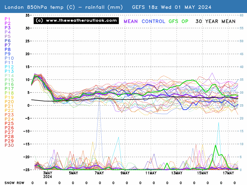
A change looks likely next week but keep an eye on those outliers between 9 - 11 August.

Originally Posted by: Brian Gaze
Yes Brian.
The Ensemble for London appears to show a decline after Wednesday 8th August next week, so from today and yesterday to upto Wednesday for London and SE England, it looks very warm and sunny in general. Nice clear blue skies today where I am.
As from my experience, I sense the GFS, UKMO and ECMWF are dropping down chilly and cool airmass and creating areas of Low Pressure in the North Atlantic Canada and NE USA and Europe the the further north you go the more chance of wind and rain as well as blustery showers and cool Autumnal weather, cool chilly days in Norway and Sweden NE Canada Southeast and West SW Greenland and Iceland and much of the Norwegian and Barents sea seeing temperatures and pressure on the Low side.
Over NW and North Europe over the next 10 days, these Low Pressure conveyor belts are being shown to track farther south in our side of North Hemisphere, and the UK and Europe is expected to turn much cooler with shorter warm and dry spells and more days seeing Low Pressure over the UK and Norway Sweden and Iceland as well as NE USA and Canada- the bendy jetstream is more able to push the Azores and Europe High as well as heat further south as they push SE from the NW and N Atlantic through UK and Norway and Norwegian Sea, often very chillly the higher up you are as well - betweek 60-90 North Lattitude.
The Models will continue to play with these scenarios and I truly hope that we get some taste of Autum this August, and I am very excited to see more very warm and hot sunny weather for the next 7 days.
The Model forecasts may well chance in a weeks time so it is still early days to make conclusions on whether or not the 10 days that follow after Wednesday 8th August bring us a return to Autumn, maybe the predictions could still change to show more summery weather but I am prepared to see it through.


 .
.
It looks like there is a lot of cooling Low Pressure in the Norwegian, Arctic and Greenland and Norway as well as Canadian Landmasses and Oceanic areas. If this happens in August then the hope is there that there could be significantly more cooler and wetter weather in these areas. The 0 to -5 deg. C at T850 hPa, and the 5-8 degrees at 850 hPa cool pooling shown on the charts and ensembles look quite interesting and relieving to us.  . The strengthening Jetstream Vectors and flattening of the blocking High's Anticyclone look awesome and more so if they actually are able to cool it down at the surface and mid and upper levels of the Atmosphere- which is what could bring a welcome change in August after what we have had this second half of June, July and the current ongoing 1st 8 days of August etc etc.
Edited by user
02 August 2018 13:09:25
|
Reason: Not Specified
Climate is warming up, Scotland and N Ireland and North England still often gets some Winter frost, ice and snow, November to March, but the SE and South UK including S Central England and Wales, together with the West and North through the year, they sometimes get more rain than London and S SE England, where some longer dry fine spells without much heavy rain is seen every year.
The North Atlantic Sea often gets some much Colder Wintry conditions from November to March Months, and Mild SW and South winds tend to be more frequent over the East and SE of North Atlantic Sea, as the Azores High tends to stay in charge.
With this warmth and heat, the Central and South UK has become mostly free of snow and frost.