Remove ads from site

Rob K
02 August 2018 12:36:34

6Z GFS ensembles. Not a pretty picture after the next Wednesday for anyone who likes warmth.


Mean London maxima hovering around 20C from the second half of next week although some hint of a slight uptick at the end.


Yateley, NE Hampshire, 73m asl
"But who wants to be foretold the weather? It is bad enough when it comes, without our having the misery of knowing about it beforehand." — Jerome K. Jerome
Saint Snow
02 August 2018 12:42:58

I'm glad we're holidaying in the second half of August not in this country.


Martin
Home: St Helens (26m asl) Work: Manchester (75m asl)
A TWO addict since 14/12/01
"How can wealth persuade poverty to use its political freedom to keep wealth in power? Here lies the whole art of Conservative politics."
Aneurin Bevan
Ally Pally Snowman
02 August 2018 12:44:02


6Z GFS ensembles. Not a pretty picture after the next Wednesday for anyone who likes warmth.


Mean London maxima hovering around 20C from the second half of next week although some hint of a slight uptick at the end.


Originally Posted by: Rob K 


I wouldn't take to much notice of the 2m temps just the 6c out today going for 24c  in reality its 30c. That's shockingly crap even by GFS standards. 


Bishop's Stortford 85m ASL.
Bolty
02 August 2018 12:47:22

Been a long time since we last seen this. The jetstream coming back to the UK for my 21st birthday? No thank you, sod off!


Scott
Blackrod, Lancashire (4 miles south of Chorley) at 156m asl.
My weather station 
Brian Gaze
02 August 2018 12:47:42

A change looks likely next week but keep an eye on those outliers between 9 - 11 August.


Brian Gaze
Berkhamsted
TWO Buzz - get the latest news and views 
"I'm not socialist, I know that. I don't believe in sharing my money." - Gary Numan
LA2B MeridFlowEuro09
02 August 2018 13:05:33


A change looks likely next week but keep an eye on those outliers between 9 - 11 August.


Originally Posted by: Brian Gaze 


Yes Brian.


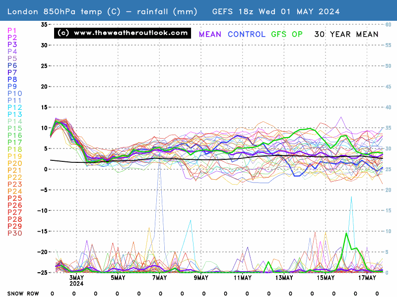
The Ensemble for London appears to show a decline after Wednesday 8th August next week, so from today and yesterday to upto Wednesday for London and SE England, it looks very warm and sunny in general.  Nice clear blue skies today where I am.


As from my experience, I sense the GFS, UKMO and ECMWF are dropping down chilly and cool airmass and creating areas of Low Pressure in the North Atlantic Canada and NE USA and Europe the the further north you go the more chance of wind and rain as well as blustery showers and cool Autumnal weather, cool chilly days in Norway and Sweden NE Canada Southeast and West SW Greenland and Iceland and much of the Norwegian and Barents sea seeing temperatures and pressure on the Low side.


Over NW and North Europe over the next 10 days, these Low Pressure conveyor belts are being shown to track farther south in our side of North Hemisphere, and the UK and Europe is expected to turn much cooler with shorter warm and dry spells and more days seeing Low Pressure over the UK and Norway Sweden and Iceland as well as NE USA and Canada- the bendy jetstream is more able to push the Azores and Europe High as well as heat further south as they push SE from the NW and N Atlantic through UK and Norway and Norwegian Sea, often very chillly the higher up you are as well - betweek 60-90 North Lattitude.


The Models will continue to play with these scenarios and I truly hope that we get some taste of Autum this August, and I am very excited to see more very warm and hot sunny weather for the next 7 days.


The Model forecasts may well chance in a weeks time so it is still early days to make conclusions on whether or not the 10 days that follow after Wednesday 8th August bring us a return to Autumn, maybe the predictions could still change to show more summery weather but I am prepared to see it through..


It looks like there is a lot of cooling Low Pressure in the Norwegian, Arctic and Greenland and Norway as well as Canadian Landmasses and Oceanic areas.  If this happens in August then the hope is there that there could be significantly more cooler and wetter weather in these areas. The 0 to -5 deg. C at T850 hPa, and the 5-8 degrees at 850 hPa cool pooling shown on the charts and ensembles look quite interesting and relieving to us.    .  The strengthening Jetstream Vectors and flattening of the blocking High's Anticyclone look awesome and more so if they actually are able to cool it down at the surface and mid and upper levels of the Atmosphere- which is what could bring a welcome change in August after what we have had this second half of June, July and the current ongoing 1st 8 days of August etc etc.


Climate is warming up, Scotland and N Ireland and North England still often gets some Winter frost, ice and snow, November to March, but the SE and South UK including S Central England and Wales, together with the West and North through the year, they sometimes get more rain than London and S SE England, where some longer dry fine spells without much heavy rain is seen every year.

The North Atlantic Sea often gets some much Colder Wintry conditions from November to March Months, and Mild SW and South winds tend to be more frequent over the East and SE of North Atlantic Sea, as the Azores High tends to stay in charge. 

With this warmth and heat, the Central and South UK has become mostly free of snow and frost.
Rob K
02 August 2018 16:34:09

Each GFS run just gets worse and worse. Proper Atlantic storm coming in by the end of next week now. I think it's fair to say that August isn't going to go as forecast.


UKMO is also pretty dire with the jet digging down almost as far as northern Spain.


Yateley, NE Hampshire, 73m asl
"But who wants to be foretold the weather? It is bad enough when it comes, without our having the misery of knowing about it beforehand." — Jerome K. Jerome
KevBrads1
02 August 2018 16:52:05

Each GFS run just gets worse and worse. Proper Atlantic storm coming in by the end of next week now. I think it's fair to say that August isn't going to go as forecast.

Originally Posted by: Rob K 


Not exactly wet in the south though. 


Week on Sunday


MANCHESTER SUMMER INDEX for 2021: 238
Timelapses, old weather forecasts and natural phenomena videos can be seen on this site
http://www.youtube.com/channel/UCgrSD1BwFz2feWDTydhpEhQ/playlists
Rob K
02 August 2018 16:58:30


Not exactly wet in the south though. 


Week on Sunday


Originally Posted by: KevBrads1 


Maybe not but cold and breezy. And in any case, I am going to be in Yorkshire next week!

I'll hang my hopes on the GFS T+384 chart 


Yateley, NE Hampshire, 73m asl
"But who wants to be foretold the weather? It is bad enough when it comes, without our having the misery of knowing about it beforehand." — Jerome K. Jerome
Ally Pally Snowman
02 August 2018 17:25:10


Each GFS run just gets worse and worse. Proper Atlantic storm coming in by the end of next week now. I think it's fair to say that August isn't going to go as forecast.


UKMO is also pretty dire with the jet digging down almost as far as northern Spain.


Originally Posted by: Rob K 


I'm sure its a case of the GFS going off on one it seems to do this when it picks up some unsettled weather it goes all in. I hope so anyway as I'm off on holiday in Dorset from the 4th.


Bishop's Stortford 85m ASL.
The Beast from the East
02 August 2018 17:33:20

still warm in the south east until Wed perhaps


However one of two GEFS show a way to keep it warm if the trough fills further west


http://www.meteociel.fr/modeles/gefs_cartes.php?code=11&ech=180&mode=1&carte=0


"We have some alternative facts for you"
Kelly-Ann Conway - special adviser to the President
Rob K
02 August 2018 19:16:59
ECM brings back higher pressure sooner than the woeful GFS run.
Yateley, NE Hampshire, 73m asl
"But who wants to be foretold the weather? It is bad enough when it comes, without our having the misery of knowing about it beforehand." — Jerome K. Jerome
Weathermac
02 August 2018 19:22:15

ECM brings back higher pressure sooner than the woeful GFS run.

Originally Posted by: Rob K 


Which is in line with the met office update which suggests mostly dry warm or very warm weather with occasional spells of cooler weather with some rain but not huge amounts of rain.

richardabdn
02 August 2018 20:00:04


Not exactly wet in the south though. 


Week on Sunday


Originally Posted by: KevBrads1 


Sickening chart. Just look at that little enclave of Western Scotland in the NE. 


Aberdeen: The only place that misses out on everything


2023 - The Year that's Constantly Worse than a Bad November
2024 - 2023 without the Good Bits
doctormog
02 August 2018 20:06:02


Sickening chart. Just look at that little enclave of Western Scotland in the NE. 


Originally Posted by: richardabdn 


We’ll see http://www.wetterzentrale.de/maps/GFSOPUK12_9_49.png 


I guess a lot of that total will depend on the next day or two and the convective precipitation forecast.


sunnyramsgate
02 August 2018 21:12:53
Probably be all change again tomorrow
Sevendust
02 August 2018 21:25:13
Smart money (and model backing) on a return to a normal summer pattern in a weeks time. The south may not be too bad with lions share of the dry weather. The switch may involve something thundery given the thermal gradient but that can wait for now
Gusty
02 August 2018 21:52:29

We are heading to Scotland tomorrow to spend some time in Cumbernauld with friends. We are planning on heading to the Edinburgh fringe on Saturday and the west coast on Sunday. After that we head down to the Lake District on Monday for 3 nights.


I'm sure when I checked a couple of days ago things were looking very set fair..on this advice we've packed shorts and t-shirts etc.


A quick scoot of the models tonight suggests a cloudy weekend in Scotland ..18c in Glasgow, 21c in brighter Edinburgh.


The lakes look decidedly cloudy and drizzly particularly Tues/ Weds with temps of 17-19c.


Suffice to say some last minute packing has now included a couple more hoodies and some jeans.  Down here jeans are normally only worn between October and April. 


The north / south divide is truly incredible and one I'm going to experience over the next few days. Having experienced heat for so long this will be a shock.


Steve - Folkestone, Kent
Current conditions from my Davis Vantage Vue
https://www.wunderground.com/dashboard/pws/IFOLKE11 
Join Kent Weather on Facebook.
https://www.facebook.com/stevewall69/ 


Brian Gaze
03 August 2018 06:15:24

Cooler but quite dry. Also a hint that temperatures could pick up again as we head through the second third of August. 


Brian Gaze
Berkhamsted
TWO Buzz - get the latest news and views 
"I'm not socialist, I know that. I don't believe in sharing my money." - Gary Numan
marco 79
03 August 2018 06:46:18
0zGfs op keeps any unsettled weather further to the North and west....The AH keeps South and East relatively warm and mostly dry out to day10...
Home : Mid Leicestershire ...135m ASL
doctormog
03 August 2018 07:04:47

0zGfs op keeps any unsettled weather further to the North and west....The AH keeps South and East relatively warm and mostly dry out to day10...

Originally Posted by: marco 79 


I think it is a more N/S split than a NW/SE one as parts of the N and E will also be in the cooler more unsettled conditions based on the GFS op and ECM.


The Beast from the East
03 August 2018 08:24:37

Azores high never far away so after the cool down on Wed, it should still be pleasant in the south and mostly dry


But the extreme heat looks to be over now for another year hopefully!


"We have some alternative facts for you"
Kelly-Ann Conway - special adviser to the President
Rob K
03 August 2018 08:45:13
ECM looks like an improvement this morning. Hoping we can squeeze out some more sunny and warmish days in two weeks’ time to coincide with a trip down to Devon. I haven’t been in the sea yet this year!
Yateley, NE Hampshire, 73m asl
"But who wants to be foretold the weather? It is bad enough when it comes, without our having the misery of knowing about it beforehand." — Jerome K. Jerome
some faraway beach
03 August 2018 08:47:08


I think it is a more N/S split than a NW/SE one as parts of the N and E will also be in the cooler more unsettled conditions based on the GFS op and ECM.


Originally Posted by: doctormog 


The GEFS graph for Plymouth looks little different from the one for London, both in terms of a return to average temps, and still little in the way of rain. So, yes. A N/S split.


2 miles west of Taunton, 32 m asl, where "milder air moving in from the west" becomes SNOWMAGEDDON.
Well, two or three times a decade it does, anyway.
The Beast from the East
03 August 2018 10:11:18

http://www.meteociel.fr/modeles/gfse_cartes.php?&ech=108&mode=1


Tuesday looks to be the last very hot day across the SE


"We have some alternative facts for you"
Kelly-Ann Conway - special adviser to the President
Users browsing this topic
Ads