Remove ads from site

Rob K
16 January 2019 11:33:38


But this morning the ECM FROM 192 Has backed away from anything cold or and easterly and has gone along with the GFS and after so much flip floppings followed by downgrades after yesterday evenings ECM i thought there can only be upgrades!!? Would you not agree?


Originally Posted by: tallyho_83 


No, the ECM is barely changed from yesterday. Maybe half a degree to one degree warmer on average at the surface than last night, unless you are only looking at the operational run in isolation?


The mean 850mb temperature by the end of the ECM ensemble is actually very slightly colder than it was last night for my location.


Yateley, NE Hampshire, 73m asl
"But who wants to be foretold the weather? It is bad enough when it comes, without our having the misery of knowing about it beforehand." — Jerome K. Jerome
Solar Cycles
16 January 2019 11:43:22
A quick question........

When do the background signals and potential become reality. I’ll get my coat.😎
idj20
16 January 2019 11:47:02

Okay, so perhaps the models are having a change of heart (when don't they ever?) regarding the potential true cold spell but at least it doesn't look like we haven't got to be dealing with explosive cyclogenesis associated with a rip roaring mid-latitude jet stream and all that s**t . . . for now.  All the time that isn't happening, we do have a chance of some transitory snow between now and into next week, but that doesn't float my boat as I'm usually too far south and too close to sea level for it.

Unless I might get a surprise 20th Feb 2012-type event out of it. 


Folkestone Harbour. 
Rob K
16 January 2019 11:48:04
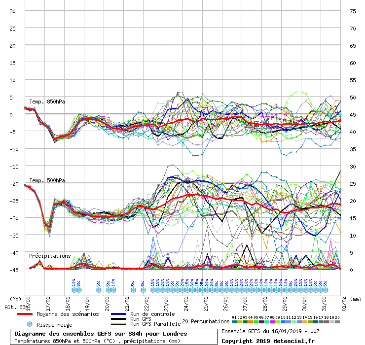
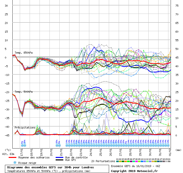
GEFS now out for the 06Z and have trended a fair bit colder in the mid term for London, Jan 22-27, with the colder cluster predominating now. Control run is fairly frigid.
Yateley, NE Hampshire, 73m asl
"But who wants to be foretold the weather? It is bad enough when it comes, without our having the misery of knowing about it beforehand." — Jerome K. Jerome
Brian Gaze
16 January 2019 11:48:33

Some mild runs now appearing in the 6z.


Brian Gaze
Berkhamsted
TWO Buzz - get the latest news and views 
"I'm not socialist, I know that. I don't believe in sharing my money." - Gary Numan
Jeff
  • Jeff
  • Advanced Member
16 January 2019 11:48:38
All, been watching that weekend storm for the US unfolding run by run. As suggested as a possibility few days ago, its now looking like its forward speed is plotted to be faster (preventing any real Greenland ridging) and its trajectory flatter, riding a briefly revitalised W-E jet out of the US. By the way, this is still a week away and explosive deepening of this low with the Gulf moisture and huge temperature contrasts may still see it slow/stall and/or recurve more northward although this is looking less likely now.

The strong flat jet doesn’t seem to last long though. The trough in the US (with Arctic air) digs right down to the Gulf Coast and thereafter, both the strength and the orientation of the jet is anyone’s guess. I have a friend who is a BA pilot of 30 years. He’s just had headwinds to the Caribbean there AND back ! he says the jetstream forecasts for the next two weeks are all over the place.

I think we still need to look to them west, before we can start looking to the East or North, for how our weather plays out last week of Jan and beyond

Jeff
On the East/West Sussex Border
70m ASL
Brian Gaze
16 January 2019 11:50:25

GEFS now out for the 06Z and have trended a fair bit colder in the mid term for London, Jan 22-27, with the colder cluster predominating now. Control run is fairly frigid.

Originally Posted by: Rob K 


Sounds like yesterday's 6z update? 


Brian Gaze
Berkhamsted
TWO Buzz - get the latest news and views 
"I'm not socialist, I know that. I don't believe in sharing my money." - Gary Numan
Rob K
16 January 2019 11:52:21


Some mild runs now appearing in the 6z.


Originally Posted by: Brian Gaze 


But overall an improvement on the 00Z set, in terms of cold, with fewer mild stragglers. (Albeit that the mild ones on the 06Z are that bit milder than on the 0Z!)


The cold clustering in the 22-25 Jan period seems a lot better than the 00Z, but I would still want to see some improvements!


Sounds like yesterday's 6z update?

Brian Gaze wrote:


No, this morning's. Comparing like with like, the 6Z is definitely a step in the right direction from the rather poor 0Z set, at least for London. (My comment about the control run was for the end of the run, not that middle period, where the control goes mild)


0Z


6Z


There are fewer mild runs, but the ones there are are more extremely mild, so the mean is only a little lower.


Not a massive improvement, but still an improvement.


I suspect a tipping point will be reached soon where one of those clusters disappears in the Jan 23-25 range, and the mean will shoot rapidly up or down.


Yateley, NE Hampshire, 73m asl
"But who wants to be foretold the weather? It is bad enough when it comes, without our having the misery of knowing about it beforehand." — Jerome K. Jerome
tallyho_83
16 January 2019 11:58:56


No, the ECM is barely changed from yesterday. Maybe half a degree to one degree warmer on average at the surface than last night, unless you are only looking at the operational run in isolation?


The mean 850mb temperature by the end of the ECM ensemble is actually very slightly colder than it was last night for my location.


Originally Posted by: Rob K 


Have I missed something then? - How come you can say it's barely changed?


Today's 00z:


Home Location - Kellands Lane, Okehampton, Devon (200m ASL)
---------------------------------------
Sean Moon
Magical Moon
www.magical-moon.com


Rob K
16 January 2019 12:00:18


Have I missed something then? - How come you can say it's barely changed?


Today's 00z:


Originally Posted by: tallyho_83 


You missed the part in bold, I think. 


No, the ECM is barely changed from yesterday. Maybe half a degree to one degree warmer on average at the surface than last night, unless you are only looking at the operational run in isolation?

Rob K wrote:


Yateley, NE Hampshire, 73m asl
"But who wants to be foretold the weather? It is bad enough when it comes, without our having the misery of knowing about it beforehand." — Jerome K. Jerome
kmoorman
16 January 2019 12:02:21


But overall an improvement on the 00Z set, in terms of cold, with fewer mild stragglers. (Albeit that the mild ones on the 06Z are that bit milder than on the 0Z!)


The cold clustering in the 22-25 Jan period seems a lot better than the 00Z, but I would still want to see some improvements!


No, this morning's. Comparing like with like, the 6Z is definitely a step in the right direction from the rather poor 0Z set, at least for London.


0Z


6Z


There are fewer mild runs, but the ones there are are more extremely mild, so the mean is only a little lower.


Not a massive improvement, but still an improvement.


I suspect a tipping point will be reached soon where one of those clusters disappears in the Jan 23-25 range, and the mean will shoot rapidly up or down.


Originally Posted by: Rob K 


I'm not particularly enthused by any of this, but there's still time for things to go colder and eventually we'll get more agreement.  


Home: Durrington, Worthing, West Sussex. (16 ASL)
Work: Canary Wharf, London
Follow me on Twitter @kmoorman1968
Rob K
16 January 2019 12:04:53

Parallel run flattens everything out totally, but shoves the jet so far south (with HP over the pole) that it still manages to cover the country in snow from northwesterlies by the end of the month.


I'd put the chances of that happening somewhere between Bob Hope and No Hope.


Yateley, NE Hampshire, 73m asl
"But who wants to be foretold the weather? It is bad enough when it comes, without our having the misery of knowing about it beforehand." — Jerome K. Jerome
Gooner
16 January 2019 12:05:51

GEFS now out for the 06Z and have trended a fair bit colder in the mid term for London, Jan 22-27, with the colder cluster predominating now. Control run is fairly frigid.

Originally Posted by: Rob K 


Some good ones in amongst the GEFS for sure ………….all is not lost , far from it 


Remember anything after T120 is really Just For Fun


Marcus
Banbury
North Oxfordshire
378 feet A S L


White Meadows
16 January 2019 12:10:35
I have a hunch we’ll start seeing bonkers cold output for the first week of Feb. Should start showing in the next few days and put this mess of a January to bed.
Chunky Pea
16 January 2019 12:11:28


 all is not lost 


Originally Posted by: Gooner 


True, but nothing is really gained either. 


I've come to the point where I am actually now looking forward to Summer. I hate summer as a rule, but such is my detestation and weariness of this soul slaughtering winter season, that I would take anything just to get out of it. 


Current Conditions
https://t.ly/MEYqg 


"You don't have to know anything to have an opinion"
--Roger P, 12/Oct/2022
briggsy6
16 January 2019 12:18:15

Can I be the first to say it?


Location: Uxbridge
LA2B MeridFlowEuro09
16 January 2019 12:18:50

The Outlook for the next 8 days or so is not very interesting.


The ECMWF, UKMO and the GFS Model runs of today at 00z etc etc.


Not much rainfall really- and neither too cold or less cold but just slightly above average temperatures are expected both day and night.


Frost will be limited.


Northern and Northwestern and Northeastern areas- could see some night frosts though.


Often cloudy, with not much in the way of sunshine.


Much of the Jetstream and Low Pressure systems are on track across the 60-90 degrees north areas of North Atlantic over the forecast period.


This weather pattern is very common in January in the last two decades.


By day 7 and 8 aka the 23-24 January it looks cold with chance of frost at night, but WSW winds then NW winds should return by Friday the 25th, maybe bringing chance of another frost overnight.


Frost at night possible in NW and North UK, on Monday the 21st.


Bombogenesis PV Low for NE USA Newfoundland SW and SE Greenland and Iceland to Svalbard with very cold arctic plunges in those areas with stormy weather for those areas.


.


Climate is warming up, Scotland and N Ireland and North England still often gets some Winter frost, ice and snow, November to March, but the SE and South UK including S Central England and Wales, together with the West and North through the year, they sometimes get more rain than London and S SE England, where some longer dry fine spells without much heavy rain is seen every year.

The North Atlantic Sea often gets some much Colder Wintry conditions from November to March Months, and Mild SW and South winds tend to be more frequent over the East and SE of North Atlantic Sea, as the Azores High tends to stay in charge. 

With this warmth and heat, the Central and South UK has become mostly free of snow and frost.
Rob K
16 January 2019 12:23:03


Some good ones in amongst the GEFS for sure ………….all is not lost , far from it 


Originally Posted by: Gooner 


It's the psychology of the op runs. If, say, the GFS had churned out P19 as the operational this morning then the mood would be totally different. Until the ensemble picks one route in the medium term and sticks with it then there is still plenty of interest even in one week's time. This is a 168hr chart, for instance:


Yateley, NE Hampshire, 73m asl
"But who wants to be foretold the weather? It is bad enough when it comes, without our having the misery of knowing about it beforehand." — Jerome K. Jerome
White Meadows
16 January 2019 12:26:40

This place is very fickle at the best of times, but you can understand the frustration for coldies.
I’ll give it til the end of Jan- if the Carlsberg output isn’t within fair grasp by then, I really will be looking forward to spring as this nonsense has gone on long enough. By that I mean the model output

soperman
16 January 2019 12:29:40

Knowing that January can sometimes be a very dry month, I wonder if January 2019 could break some records for London and the South East for lack of precipitation? Very AH dominated outlook.

Rob K
16 January 2019 12:33:10


This place is very fickle at the best of times, but you can understand the frustration for coldies.
I’ll give it til the end of Jan- if the Carlsberg output isn’t within fair grasp by then, I really will be looking forward to spring as this nonsense has gone on long enough. By that I mean the model output


Originally Posted by: White Meadows 


Don't worry, Michael Gove assures us winter is on the way, I saw it on the front of the Standard last night.


Also, check out the latest Met Office long-ranger before getting too despondent. 


Yateley, NE Hampshire, 73m asl
"But who wants to be foretold the weather? It is bad enough when it comes, without our having the misery of knowing about it beforehand." — Jerome K. Jerome
fairweather
16 January 2019 12:35:44

GEFS now out for the 06Z and have trended a fair bit colder in the mid term for London, Jan 22-27, with the colder cluster predominating now. Control run is fairly frigid.

Originally Posted by: Rob K 


Have they? The mean for the range you have quoted rises from -5C to -2C and the main colder cluster just below the mean from -6C to -4C. 


S.Essex, 42m ASL
Gooner
16 January 2019 12:38:41


It's the psychology of the op runs. If, say, the GFS had churned out P19 as the operational this morning then the mood would be totally different. Until the ensemble picks one route in the medium term and sticks with it then there is still plenty of interest even in one week's time. This is a 168hr chart, for instance:


Originally Posted by: Rob K 


Bang on 


Remember anything after T120 is really Just For Fun


Marcus
Banbury
North Oxfordshire
378 feet A S L


jhall
16 January 2019 12:39:04

In today's 06Z GFS ensemble, for the period 23rd-26th there's a range of over 15C between the 850 mb temperature of the coldest and the mildest members! The 23rd is only a week away, so surely what's forecast must settle down soon? If there's such a wide range of solutions in the medium term, then at the moment trying to determine what's likely to happen at 10 days and beyond seems like a waste of time. 


Cranleigh, Surrey
kmoorman
16 January 2019 12:42:28

I have a hunch we’ll start seeing bonkers cold output for the first week of Feb. Should start showing in the next few days and put this mess of a January to bed.

Originally Posted by: White Meadows 


My hunch is we'll continue to see bonkers cold output at day 10+ until late March. 


Home: Durrington, Worthing, West Sussex. (16 ASL)
Work: Canary Wharf, London
Follow me on Twitter @kmoorman1968

Remove ads from site

Ads