Remove ads from site

Taylor1740
18 June 2021 19:59:45

A lovely GFS this evening, if I'm honest, with warmth and high pressure not too far away. We could be on course for a classic June/first half of summer if this trend persists.

Originally Posted by: Bolty 


ECM not so great though, and GEFS showing a very average outlook


NW Leeds - 150m amsl
Sevendust
18 June 2021 21:04:23

Again, once we get past the next few days it looks a pretty average outlook. No notably wet/cold or hot themes emerging

moomin75
18 June 2021 21:12:59

A lovely GFS this evening, if I'm honest, with warmth and high pressure not too far away. We could be on course for a classic June/first half of summer if this trend persists.

Originally Posted by: Bolty 


This GFS is not likely to be anywhere near the mark.


Totally against the general signals from elsewhere.


Witney, Oxfordshire
100m ASL
TimS
  • TimS
  • Advanced Member
18 June 2021 22:46:56
I don’t know where all this optimism is coming from. We’ve already had about a month of rainfall in 2 days and this evening’s runs are utter shockers. 18z GFS has maxima in the low to mid teens most of next week and through next weekend. ECM has a similar 2007/2012 pattern. It’s the worst outlook I’ve seen for years. I think people are getting misled by the superficially warm uppers. On the ground it looks dire.
Brockley, South East London 30m asl
Tim A
18 June 2021 22:58:35

I don’t know where all this optimism is coming from. We’ve already had about a month of rainfall in 2 days and this evening’s runs are utter shockers. 18z GFS has maxima in the low to mid teens most of next week and through next weekend. ECM has a similar 2007/2012 pattern. It’s the worst outlook I’ve seen for years. I think people are getting misled by the superficially warm uppers. On the ground it looks dire.

Originally Posted by: TimS 


Suppose it depends on where you are in the country as well. If you live in NW England you have just experienced two nice summer days, above average,  20-21c with no rain , the unsettled spell has not arrived yet.  Tomorrow will be decent too across parts of N England. Temps in Southern England do look particularly suppressed , but it is possible further north it will be nearer average and may escape many of the rain bands if the low pressure stays to the south.  Could easily end up crap for all though, fine margins.


Tim
NW Leeds
187m asl

 My PWS 
Brian Gaze
19 June 2021 06:16:27

GFS is being upgraded to v16.1.2 on Tuesday I think.


Brian Gaze
Berkhamsted
TWO Buzz - get the latest news and views 
"I'm not socialist, I know that. I don't believe in sharing my money." - Gary Numan
Ally Pally Snowman
19 June 2021 06:42:22

Looking pretty dry after the 23rd.


Bishop's Stortford 85m ASL.
Ally Pally Snowman
19 June 2021 06:56:46

Decent UKMO this morning has high pressure building quite nicely over the UK. ECM is a stinker though low pressure takes up home over Moomin's house for a week.


Bishop's Stortford 85m ASL.
moomin75
19 June 2021 07:00:20


Decent UKMO this morning has high pressure building quite nicely over the UK. ECM is a stinker though low pressure takes up home over Moomin's house for a week.


Originally Posted by: Ally Pally Snowman 

ECM is exactly the scenario I am anticipating coming off.


Witney, Oxfordshire
100m ASL
DEW
  • DEW
  • Advanced Member
19 June 2021 07:04:42

WXmaps beginning to look warmer for the S Coast in week 2 though quite a lot of rain only just across the Channel. Scotland cooler, some rain in the NE later. Jet looping weakly and rather aimlessly around the UK for now, perhaps a more organised loop around Thu 3rd.


GFS  - LP wandering around Biscay for the next week or so with tendency for weak ridge of HP across Scotland. The LP almost vanishes Thu 24th but revives over Ireland before returning S-wards. All pushed out of the way by a strong N-ly blast Thu 1st from a new LP over Norway, slowly giving way to W-lies. (The LP over Norway has come out of nowhere and as is the case for such unexpected developments, could just as easily be absent from tomorrow's chart)


GEFS - In the S, still some thundery rain to get out of the way in the next 2-3 days, then continuing with small amounts though with a suggestion of more active period around Sat 26th. Scotland has persistent but small amounts throughout. Temps generally in a scramble around the norm. The N-ly blast above shows up in control and op but only in a few other runs.


ECM - good agreement with GFS to end of run Mon 28th


War does not determine who is right, only who is left - Bertrand Russell

Chichester 12m asl
Ally Pally Snowman
19 June 2021 07:14:47


ECM is exactly the scenario I am anticipating coming off.


Originally Posted by: moomin75 


I think it's the favourite scenario at the moment.  I'm still hopeful for July AAM is due to rise again and long range ECM has had high pressure building in quite nicely .


Bishop's Stortford 85m ASL.
moomin75
19 June 2021 07:22:04


I think it's the favourite scenario at the moment.  I'm still hopeful for July AAM is due to rise again and long range ECM has had high pressure building in quite nicely .


Originally Posted by: Ally Pally Snowman 

I agree, a couple more weeks of this unsettled spell then a chance of an improvement by mid-July.


Witney, Oxfordshire
100m ASL
SJV
19 June 2021 07:30:15


I agree, a couple more weeks of this unsettled spell then a chance of an improvement by mid-July.


Originally Posted by: moomin75 


I get the ECM is the worst of the models this morning, so you'll naturally gravitate towards it, but where is this two/three weeks of unsettled weather coming from?


As Tim A said, many areas further north haven't even started an unsettled spell yet! There's a decent amount of dry weather next week, too.

Downpour
19 June 2021 07:58:25


Decent UKMO this morning has high pressure building quite nicely over the UK. ECM is a stinker though low pressure takes up home over Moomin's house for a week.


Originally Posted by: Ally Pally Snowman 


Isn’t it there constantly? My understanding is that Witney produces its own stationary lows. 


Chingford
London E4
147ft
doctormog
19 June 2021 08:01:26


Isn’t it there constantly? My understanding is that Witney produces its own stationary lows. 


Originally Posted by: Downpour 


And a continuation of the NW/SE split for the coming week:


Joe Bloggs
19 June 2021 08:01:39

I don’t know where all this optimism is coming from. We’ve already had about a month of rainfall in 2 days and this evening’s runs are utter shockers. 18z GFS has maxima in the low to mid teens most of next week and through next weekend. ECM has a similar 2007/2012 pattern. It’s the worst outlook I’ve seen for years. I think people are getting misled by the superficially warm uppers. On the ground it looks dire.

Originally Posted by: TimS 


Maybe you should move up to the COVID-ridden barren part of the country that is NW England. Dry as a bone up here. 


Our rain symbols have disappeared for tomorrow too. 


Manchester City Centre, 31m ASL

Crepuscular Ray
19 June 2021 08:27:28
The very dry spell will continue up here according to the models. Only 2.8mm in 25 days here. Garden watering every day!
Jerry
Edinburgh, in the frost hollow below Blackford Hill
bledur
19 June 2021 08:39:26


Isn’t it there constantly? My understanding is that Witney produces its own stationary lows. 


Originally Posted by: Downpour 


 Any day in Witney


Heavy rain damage - Stock Illustration [13525574] - PIXTA

overland
19 June 2021 09:06:02


Maybe you should move up to the COVID-ridden barren part of the country that is NW England. Dry as a bone up here. 


Our rain symbols have disappeared for tomorrow too. 


Originally Posted by: Joe Bloggs 


Same for the SW or at least this part of Wales and all rain symbols for tomorrow now removed from what was a few days ago continuous heavy rain. Our yet to be completed patio is a dust bowl!


Mumbles, Swansea. 80m asl
TimS
  • TimS
  • Advanced Member
19 June 2021 10:09:43

The trouble with this coming weather is that the large scale pattern is actually quite good: positive AO and a Northward tracking jet stream, with ridging over Europe. It's just we have a little mini trough determined to stick around Biscay, France and Southern UK. So we are wasting otherwise decent synoptics. It's not like May when a Greenland high dominated.


One very interesting feature showing up repeatedly in the models for just over a week's time is a quite extreme example of lee heating downwind of the Greenland plateau - in effect a mega-foehn. It shows up in 850s and brings home grown values of 15C+ in the far North Atlantic, reaching close to the UK and brushing Iceland on a hot Northwesterly.
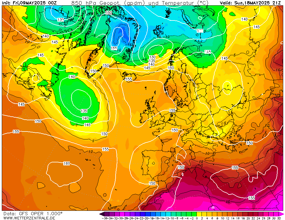


I don't think I've seen anything that pronounced before, though you sometimes get a similar tongue of warm uppers when there is a strong Easterly flow over the Norwegian mountains bringing warmth to Shetland.


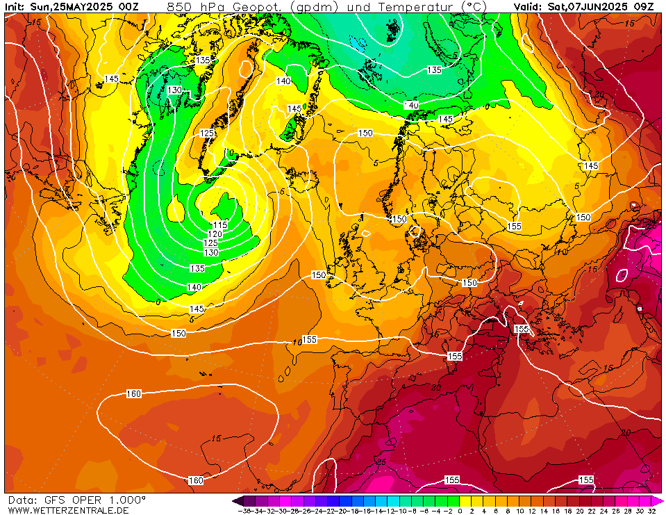
Followed, in this morning's GFS, by this horrific chart:


Brockley, South East London 30m asl
Jiries
19 June 2021 11:02:02


The trouble with this coming weather is that the large scale pattern is actually quite good: positive AO and a Northward tracking jet stream, with ridging over Europe. It's just we have a little mini trough determined to stick around Biscay, France and Southern UK. So we are wasting otherwise decent synoptics. It's not like May when a Greenland high dominated.


One very interesting feature showing up repeatedly in the models for just over a week's time is a quite extreme example of lee heating downwind of the Greenland plateau - in effect a mega-foehn. It shows up in 850s and brings home grown values of 15C+ in the far North Atlantic, reaching close to the UK and brushing Iceland on a hot Northwesterly.


I don't think I've seen anything that pronounced before, though you sometimes get a similar tongue of warm uppers when there is a strong Easterly flow over the Norwegian mountains bringing warmth to Shetland.


Followed, in this morning's GFS, by this horrific chart:


Originally Posted by: TimS 


Imagine the 15C uppers from Greenland come here I wonder if we still can get 30C temperatures from the NW? Highest temps from the NW when i was living in Epsom was 26C in the 90's I can't remember which but it was sunny spells and very warm so perhaps had high uppers being delivered that time but no internet that time know.  22-23C are the best you can get from the NW on average.


Plus how come the 15C uppers survived long cold sea crossing? 15C uppers entering the UK landmass always reduce it as it move north.

Ally Pally Snowman
19 June 2021 11:30:45

The 6z GFS is uber settled and becomes hot by the end.


Bishop's Stortford 85m ASL.
ballamar
19 June 2021 13:03:33


The 6z GFS is uber settled and becomes hot by the end.


Originally Posted by: Ally Pally Snowman 


why it’s dangerous to plump for unsettled in the long term! Even the northerly would be pleasant in the south

Retron
19 June 2021 14:18:05


Followed, in this morning's GFS, by this horrific chart:


Originally Posted by: TimS 


That's a lovely chart - about as good as I could hope for in summer.


Won't happen though, a perfectly placed cold plunge like that is most unlikely, especially that far out.


Leysdown, north Kent
Col
  • Col
  • Advanced Member
19 June 2021 15:18:25


That's a lovely chart - about as good as I could hope for in summer.


Won't happen though, a perfectly placed cold plunge like that is most unlikely, especially that far out.


Originally Posted by: Retron 


You seriously need to move to Shetland!


Col
Bolton, Lancashire
160m asl
Snow videos:
http://www.youtube.com/channel/UC3QvmL4UWBmHFMKWiwYm_gg

Remove ads from site

Ads