Remove ads from site

Rob K
07 January 2016 11:31:02
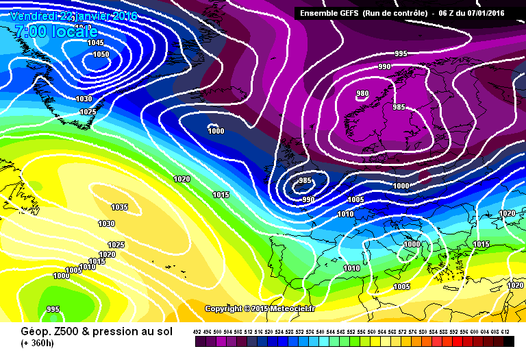
Control run brings in a proper (south)easterly...

http://modeles7.meteociel.fr/modeles/gens/runs/2016010706/gens-0-1-240.png 
Yateley, NE Hampshire, 73m asl
"But who wants to be foretold the weather? It is bad enough when it comes, without our having the misery of knowing about it beforehand." — Jerome K. Jerome
Robertski
07 January 2016 11:34:16


Completely agree with this... 😕


All of the cold is also over a week away... Far to far away to be taken remotely serious.


Originally Posted by: picturesareme 


You can take it seriously, just not too seriously. It does appear it will be cold, as I have said earlier, the devil is in the detail. Lets just get his pattern changed to something more seasonal and worry about the specifics a couple of days beforehand.

The Beast from the East
07 January 2016 11:35:00

Have to say that Azores low on the Euro's is worrying, these small features usually get better picked up as we get closer so it will be very interesting to see what the models do with it on the 12z's

Originally Posted by: JoeShmoe99 


Maybe the reason why the METO forecast hasn't changed. The cold air may retreat from the south very soon.


This country always finds a way to avoid snow


"We have some alternative facts for you"
Kelly-Ann Conway - special adviser to the President
kmoorman
07 January 2016 11:36:46
There are some crazy options in the GFES FI section.
Home: Durrington, Worthing, West Sussex. (16 ASL)
Work: Canary Wharf, London
Follow me on Twitter @kmoorman1968
Rob K
07 January 2016 11:39:27


Maybe the reason why the METO forecast hasn't changed. The cold air may retreat from the south very soon.


This country always finds a way to avoid snow


Originally Posted by: The Beast from the East 


Based on tweets from professional forecasters I would say the reason it hasn't changed yet is because of the uncertainty, not because mild options are the favourite (they're not).


I don't see what people are worried about with the Azores low. It is the Azores low that is allowing the block to stay up in the first place. The Azores low can't scupper a cold spell, the only thing that can is the block collapsing or retreating way out west.


And the control run goes blizzard crazy in la la land  


Yateley, NE Hampshire, 73m asl
"But who wants to be foretold the weather? It is bad enough when it comes, without our having the misery of knowing about it beforehand." — Jerome K. Jerome
Sinky1970
07 January 2016 11:40:00
There's agreement that it will turn cooler/colder next week but a widespread snowfall event is still 7 days away according to the latest GFS. It's a long time to wait in weather, sometimes these events crop up in less than 3 days and can't be forecasted. I remember 5 or 6 days ago it was meant to snow here tomorrow according to a GFS run, so i never get pulled into runs much longer than 5 days.
Essan
07 January 2016 11:40:39

LOL!  Some of us have gone all winter without an airfrost.  Or even a day with below average maximas.  Now it's looking cold and frosty from early next week for at least 10 days - with a risk of snow just about anywhere.  The best winter charts in years.   And some are bemoaning the fact it might turn a bit milder again in 2 week's time and the rest the fact that it might not be be incredibly exceptionally cold.

Well, I guess if we don't see -15c in London by Wednesday then winter is over .....


Andy
Evesham, Worcs, Albion - 35m asl
Weather & Earth Science News 

Anyone who is capable of getting themselves made President should on no account be allowed to do the job - DNA
Rob K
07 January 2016 11:43:19
http://modeles7.meteociel.fr/modeles/gens/runs/2016010706/graphe3_1000_311_146___.gif 


.... and the long ones out too now: http://modeles7.meteociel.fr/modeles/gens/runs/2016010706/graphe3_1000_301_146___.gif


COLDEST OF THE WINTER SO FAR.


That's a hell of a precip spike too!


Yateley, NE Hampshire, 73m asl
"But who wants to be foretold the weather? It is bad enough when it comes, without our having the misery of knowing about it beforehand." — Jerome K. Jerome
Rob K
07 January 2016 11:47:42
http://www.wetterzentrale.de/pics/MT8_London_ens.png 

(although it has plotted the op run wrong again).


 A decent cluster keep it at -7C or so right out to the end.


Comfortably the coldest so far. The train may have left the station...


Yateley, NE Hampshire, 73m asl
"But who wants to be foretold the weather? It is bad enough when it comes, without our having the misery of knowing about it beforehand." — Jerome K. Jerome
soperman
07 January 2016 11:48:33


My ''look west'' post yesterday appears to be coming to fruition and this low looks to be potent whether it falls as rain or snow so we could have more flooding problems next week - maybe for different areas - the Somerset levels come to mind.


I know I will be against the trend of thought here but the GFS 06z to my eyes does not show an elongated period of cold and if anything hints at a flattening of the pattern with a succession of northerly lows weakening the greenie high - this would tie in with the Meto's suggestion of a brief colder incursion. However that is all F.I. and I for one look forward to a pattern change and relief from this dross no matter how brief.


Russwirral
07 January 2016 11:50:43


Based on tweets from professional forecasters I would say the reason it hasn't changed yet is because of the uncertainty, not because mild options are the favourite (they're not).


I don't see what people are worried about with the Azores low. It is the Azores low that is allowing the block to stay up in the first place. The Azores low can't scupper a cold spell, the only thing that can is the block collapsing or retreating way out west.


And the control run goes blizzard crazy in la la land  


Originally Posted by: Rob K 


completely agree - that Azores low is absolutley key to anything happening.  It stops the GH disappearing to lower latitudes, whilst also drawing down the cold air in the correct direction.. otherwise you can wave goodbye to the cold air as it merrily drifts over to Germany and we're left with nothing but a few coastal wintry showers over wales.


Rob K
07 January 2016 11:52:05
Synchronicity: my wife just phoned, she's in the sales and says the winter coat I looked at a couple of months ago is now half price and do I want her to get it for me 🙂
Yateley, NE Hampshire, 73m asl
"But who wants to be foretold the weather? It is bad enough when it comes, without our having the misery of knowing about it beforehand." — Jerome K. Jerome
kmoorman
07 January 2016 11:53:07


http://modeles7.meteociel.fr/modeles/gens/runs/2016010706/graphe3_1000_311_146___.gif 


.... and the long ones out too now: http://modeles7.meteociel.fr/modeles/gens/runs/2016010706/graphe3_1000_301_146___.gif


COLDEST OF THE WINTER SO FAR.


That's a hell of a precip spike too!


Originally Posted by: Rob K 


And no early mild options this time - that 'risk period' seems to be less risky now.


Home: Durrington, Worthing, West Sussex. (16 ASL)
Work: Canary Wharf, London
Follow me on Twitter @kmoorman1968
Russwirral
07 January 2016 11:53:17
How are the website hits going Brian? Have you hit website nirvana yet?
ITSY
07 January 2016 11:57:39
Excellent ens this morning, to match another excellent ECM. With UKMO and GEM both good in their own right, that's some output. The GEFS06z is the best of the season for sure!
kmoorman
07 January 2016 11:59:39

Excellent ens this morning, to match another excellent ECM. With UKMO and GEM both good in their own right, that's some output. The GEFS06z is the best of the season for sure!

Originally Posted by: ITSY 


And to think we were getting stressed about it.


What I find very interesting is the growing signal for a more prolonged cold spell here.  Lot's of re-loads from the north, with brief Easterlies in the mix.


Home: Durrington, Worthing, West Sussex. (16 ASL)
Work: Canary Wharf, London
Follow me on Twitter @kmoorman1968
Shropshire
07 January 2016 12:00:10


Maybe the reason why the METO forecast hasn't changed. The cold air may retreat from the south very soon.


This country always finds a way to avoid snow


Originally Posted by: The Beast from the East 


The METO forecast hasn't changed for a few days, the Azores Low affair is a separate issue - to my mind the forecast still relates to toppling - not ending in a a complicated set-up involving lows from the SW.


From December 27th 2020, zonality will be banned from mixing with the UK. We appreciate that this may come as a shock to younger people and old Uncle Barty. This ban will last for a minimum of ten days.
Weathermac
07 January 2016 12:01:54

There's agreement that it will turn cooler/colder next week but a widespread snowfall event is still 7 days away according to the latest GFS. It's a long time to wait in weather, sometimes these events crop up in less than 3 days and can't be forecasted. I remember 5 or 6 days ago it was meant to snow here tomorrow according to a GFS run, so i never get pulled into runs much longer than 5 days.

Originally Posted by: Sinky1970 


Not sure where you get that from ?? Being some 30 miles from you I avidly watch all the runs daily and I cannot remember seeing GFS saying snow this week .

mildmildwest
07 January 2016 12:06:51

Haven't yet worked out how to paste a screenshot here, but the GEFS 6z ensembles are beautiful. Mean is now -6/7 for a good 4 days 

Brian Gaze
07 January 2016 12:09:39

These look very good for cold but I've not stepped through the Ps yet.


Brian Gaze
Berkhamsted
TWO Buzz - get the latest news and views 
"I'm not socialist, I know that. I don't believe in sharing my money." - Gary Numan
Russwirral
07 January 2016 12:10:38


Haven't yet worked out how to paste a screenshot here, but the GEFS 6z ensembles are beautiful. Mean is now -6/7 for a good 4 days 


Originally Posted by: mildmildwest 


you cant paste screenshots.  unless you post it on an image hosting site - such as Imgur.  Other copy and paste elements ie from a GFS picture which is already hosted by a webpage else where will copy and paste.


So if you are trying to copy and paste the ensmbles - then right click and copy image - or copy the link.  Then paste that into a reply - note: do not use quick reply as the paste funcationality doesnt work there. you have to click at the top or bottom of the forum page on post a reply to allow that to work.  If you see the Smileys on the left - then you can paste.


Russwirral
07 January 2016 12:12:37
I wonder how long until we see an advanced warning from the Met.
The Beast from the East
07 January 2016 12:13:53


 The train may have left the station...


Originally Posted by: Rob K 


destination Greece


"We have some alternative facts for you"
Kelly-Ann Conway - special adviser to the President
mildmildwest
07 January 2016 12:22:34


you cant paste screenshots.  unless you post it on an image hosting site - such as Imgur.  Other copy and paste elements ie from a GFS picture which is already hosted by a webpage else where will copy and paste.


So if you are trying to copy and paste the ensmbles - then right click and copy image - or copy the link.  Then paste that into a reply - note: do not use quick reply as the paste funcationality doesnt work there. you have to click at the top or bottom of the forum page on post a reply to allow that to work.  If you see the Smileys on the left - then you can paste.


Originally Posted by: Russwirral 


Cheers! Seems to be an unwritten rule that Brian pastes the ensembles first anyway 

mildmildwest
07 January 2016 12:29:52

Remove ads from site

Ads