I'm doing a bit of 'waiting and seeing' at the mo, as the models continue to toy around with the changes afoot both in the tropics and stratosphere.
With respect to the latter, it's amazing how well the current situation at 70 hPa corresponds to what's expected to evolve down at our level next week:
http://earth.nullschool.net/#current/wind/isobaric/70hPa/orthographic=8.38,73.24,315/loc=-26.332,48.238
It also shows how the stretching and sort-of-splitting is weakening the flow in some parts of the globe. Alas, not in our region! For us it's more about how that lobe is reaching increasingly far south (displacement still ongoing), which in time means that, as the strongest flow at the base of the stratosphere shifts south, so too will the addition of zonal momentum across the European sector - hence the jet dives down into Europe. Shame the pattern is too far west for the south to join in the fun within the first week or so, but what can you do.
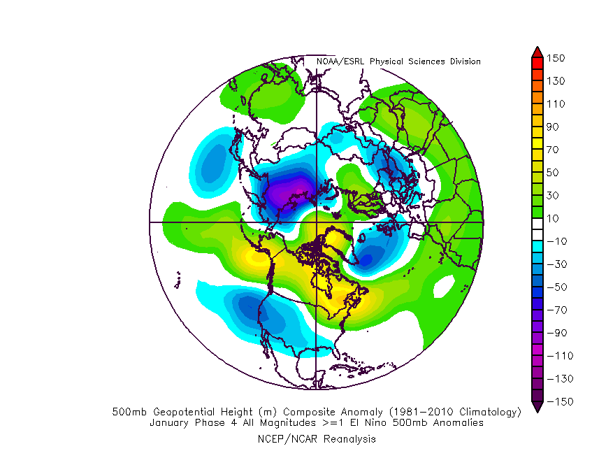
It is possible for forcing from the tropics to override this, but as it happens, the MJO has ventured into phase 4, which corresponds to a pattern that lends support to the stratospheric pattern:

This is what I spent a week or so banging on about - it's allowing the west-based negative NAO pattern to emerge, albeit somewhat stutteringly in the current model output.
It gives us a decent starting point for the month, given that seasonal wavelength changes promote a shift east in areas of high pressure near or over Greenland. It wouldn't count for much if the vortex was to return to that area and regain strength, but the trend of the day has been away from such a scenario, with the vortex becoming very strained indeed through the second week of Feb. GFS has even dared to tease us with a split which really would put the cat among the pigeons.

It's seen at all levels, making it a major SSW, but the first signs take until day 12 to appear so you'd best make room for the truckload of salt that's needed when viewing this chart 
Edited by user
29 January 2016 20:03:10
|
Reason: Not specified
If you have any problems or queries relating to TWO you can Email
[email protected] https://twitter.com/peacockreports 2023's Homeland Extremes:
T-Max: 30.2°C 9th Sep (...!) | T-Min: -7.1°C 22nd & 23rd Jan | Wettest Day: 25.9mm 2nd Nov | Ice Days: 1 (2nd Dec -1.3°C in freezing fog)
Keep Calm and Forecast On